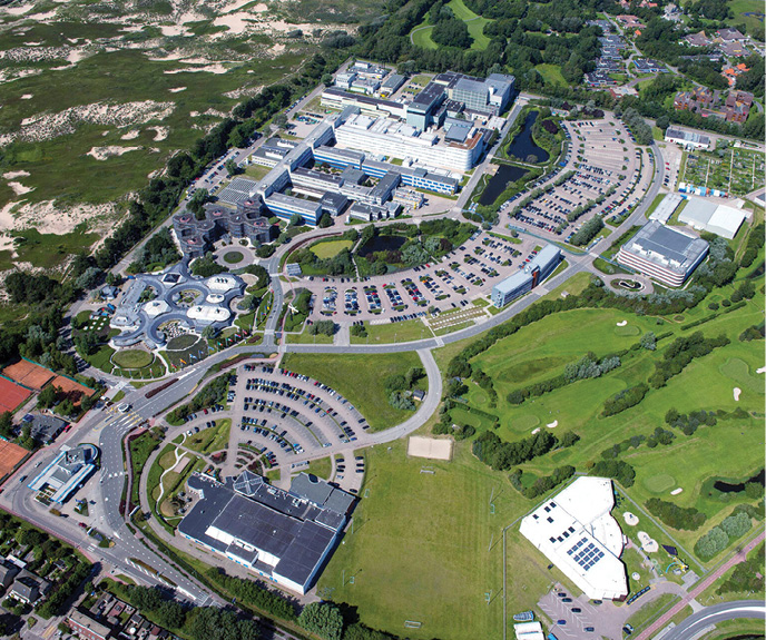
Rokubun, leading the HANSEL initiative, has set up an intelligent and flexible ‘smart city’ infrastructure at The European Space Agency’s sprawling ESTEC facility in Noordwijk. The innovative system establishes the basis for future living space control and monitoring networks that will deliver key position-based services and other benefits for both citizen inhabitants and urban authorities.
The smart city scenario has become a familiar one to followers of high-tech. Picture here, if you will, living spaces where lights and information and entertainment systems switch on and off automatically as you move from room to room and from building to building, urban factories and warehouses staffed by autonomous robots operating without human intervention, transport systems where driverless taxis pull up to the curb right when you need them and where drones and other unmanned delivery vehicles place goods into your hands within minutes, wherever you may be.
Such spaces, first imagined by science fiction writers, are no longer a promise of the distant future, but are, slowly but surely, becoming a present-day reality.
“A smart city is an urban environment that exploits information and communication technology to improve the operational efficiency of the services delivered there,” said Miquel Garcia-Fernandez, CTO and co-founder of Barcelona-based Rokubun, a company that develops high-accuracy navigation solutions for mass-market devices. Rokubun leads the HANSEL project, demonstrating how to design and implement smart city infrastructure, using for its testbed the European Space Agency’s (ESA) European Space Research and Technology Centre (ESTEC) in Noordwijk, the Netherlands. The largest of several ESA facilities spread across Europe, ESTEC is known to visitors from around the world as the home of ESA’s renowned Space Expo. It also houses one of the world’s most advanced navigation laboratories, the aptly named ESTEC Navigation Laboratory.
“ESTEC is not a city,” Garcia-Fernandez said, “but it is a large campus, with buildings, vehicles and streets, and it does resemble the urban environment. As such, it features the most common GNSS hazards that occur in a city, such as obscured view, multipath, and so on, making it the perfect setup to test and validate new technologies.”
Applications and services associated with smart cities are, by all accounts, likely to depend on well-conceived, seamless positioning, navigation and timing (PNT) infrastructure. ESTEC Radio Navigation Engineer Rui Sarnadas, ESA’s onsite project officer for HANSEL, said, “The prime goal of the HANSEL testbed demonstrator is to integrate various technologies in the field of positioning and navigation. What we have at ESTEC is a delimited geographic and administrative area in which different types of electronic data collection sensors can request, provide and exchange information among themselves within a managed network.”
A fundamental aspect of HANSEL, and one of the things that make it so innovative when compared to other smart city initiatives, is the network exchanges are performed via a centralized server, the brain of the smart city, so to speak, and not in a direct peer-to-peer fashion. This allows for the execution of monitoring and control activities, as well as ad-hoc deployments, test campaigns and data collection for analysis.
GNSS plus
“Besides the cornerstone GNSS applications,” Sarnadas said, “the testbed deploys sensors and services leveraging on Wi-Fi and cellular infrastructure, with the objective of exploring and characterizing different PNT techniques such as GNSS+Wi-Fi hybridization, GNSS+cellular snapshot positioning, RTK and GNSS cooperative positioning.”
The target, he said, is to demonstrate the concept of connected infrastructure that enables users to take advantage of the different technologies readily available in an urban context, for example via network connectivity and Android applications.
“With the HANSEL project, we’re providing more accurate and robust positioning capabilities,” Garcia-Fernandez said. “The main components of the testbed revolve mostly around satellite navigation systems and include collaborative positioning technology of user terminals, GNSS snapshot receivers to monitor interference and jamming, and the deployment of Wi-Fi access points and terminals that are compliant with the 802.11mc protocol.”
Under HANSEL, GNSS and Wi-Fi are hybridized in a tight coupling strategy, at the ranging level. Compliance with the 802.11mc, specifying the set of media access control and physical layer protocols for implementing Wi-Fi communication, enables precise measurement of the travel time, i.e. ranges instead of signal strength, between terminals and access points. This creates a seamless indoor/outdoor positioning system, a firm foundation into which other ranging-based systems can be integrated, such as ultra-wideband [UWB] or 5G. “With an affordable reference GNSS receiver used with our testbed,” Garcia-Fernandez said, “we can achieve accurate positioning in a smart city scenario by means of RTK.”
“Of course, we’re working at a smaller scale than an actual city,” Sarnadas said, “but the system as implemented provides us a valuable means for deployments, experimentations and tests in our controlled setting. Having roads, buildings, canopy and indoor environments similar to an open-sky and light urban settings, we gain the advantage of having end-to-end control over the deployment, meaning location and type of sensors, users, etcetera, and the testbed services themselves. Bringing together all of the available infrastructure—not only GNSS-related but also the Wi-Fi and cellular networks—we are able to exercise, generate and assess test scenarios for different applications.”
HANSEL has carried out a number of GNSS+Wi-Fi positioning experiments with a single smartphone, cooperative positioning using GNSS measurements with two smartphones, and snapshot positioning with GNSS+cellular SDR-based sensors and remote processing.
Sarnadas said HANSEL is delivering a number of real benefits: “One clear example is the expected increase in position solution availability and accuracy, when GNSS stand-alone solutions are impaired or simply not available. For this, the use of Wi-Fi RTT [Round-Trip-Time] measurements, of cooperative positioning, or of hybridization with cellular measurements, is fundamental.”
With the HANSEL system in place, where sensors, users and infrastructure can be mapped, supervised and maintained, additional benefits become evident. “To name a few,” Sarnadas said, “we can see energy saving by provision of a snapshot processing service, both for GNSS and cellular receivers, improved accuracy for GNSS users thanks to the availability of a controlled base station for RTK. We can deliver better hybrid positioning services by maintaining and disseminating accurate locations and timing for cellular base stations and Wi-Fi access points.”
Better quality of service (QoS) is assured using a network of sensors for spectrum monitoring and interference detection and localization. Safety and security are increased via protected commutations for authorized users only, and data exchange over a dedicated, private, smart city network.
“Finally,” Sarnadas said, “we believe we can get more efficient resource usage using centralized asset tracking and monitoring, with potential for optimizations and real-time management of registered positioning measurements, for example traffic jams, emergency situations and ad hoc deployments.”
Like clockwork
Rokubun is working with a number of key partners on the HANSEL project.
“The Links Foundation has provided the expertise in the design and requirement specifications of a navigation testbed that may be potentially used in a smart city context,”Garcia-Fernandez said, “while Politecnico di Torino, in Italy, has been responsible for the design and implementation of a collaborative positioning system based on GNSS for smartphones.”
The Universitat Autònoma de Barcelona designed and implemented the GNSS snapshot capabilities for interference and jamming monitoring and Spain’s Traffic Now is responsible for the testbed web interface design.
“At Rokubun, we have been the prime contractor and responsible for the design of the testbed architecture, deployment of the complete system, including the GNSS reference station, and also the definition and implementation of the GNSS + Wi-Fi hybridization technology,” Garcia-Fernandez said.
“We wanted to deploy a smart city initiative at ESTEC to enhance our infrastructure in support of multiple R&D and industrial activities,” Sarnadas said. “In this sense, we wanted the HANSEL testbed to give us more flexibility on the campus, effectively bringing ESTEC closer to a ‘smart campus’.”
ESA issued a call for tenders under its Technology Development Element (TDE) program, aimed at providing concepts and demonstrators, at lower technology readiness level (TRL), for key ESA technology objectives.
“In this framework,” Sarnadas said, “the activity ‘Navigation and GNSS in Smart Cities – Testbed Concept Definition,’ now known as HANSEL, was introduced to capture a set of positioning and navigation technologies and techniques in a comprehensive and flexible testbed that allows real-world demonstration of the main concepts.”
Under ESA’s tender procedure, a number of excellent proposals were comprehensively evaluated.
“For ESA, the task is never straightforward,” Sarnadas said, “since we are fortunate enough to receive very good proposals from multiple European players, from industry to academia. In the end, the HANSEL proposal covered all the objectives and tasks that were called for and the consortium brought forward indispensible expertise in the relevant areas.”
“This was a competitive process,” Garcia-Fernandez said. “Once we were selected, the execution of the project ran through several phases—design, implementation and testing—all closely monitored by ESA technical officers through regular reporting as well as in-depth technical meetings and reviews at the end of each phase.”
In the run-up to the deployment of HANSEL at the ESTEC site, the team carried out a series of key tests on a football field, where a reference station like the one to be used at ESTEC was employed to demonstrate precise positioning. The system successfully followed, with high accuracy, the trajectory of a GNSS receiver placed on a moving cart. Additional GNSS software receivers placed on the same cart were used to assess the testbed’s snapshot processing capabilities.
“We took a step-by-step approach with the HANSEL deployment,” Sarnadas said. “It is not only a testbed but also an R&D tool in itself. For example, although many services are exploited continuously, several sensors are not permanently fixed within the campus and can be moved around, configured and used in service of specific ad hoc campaigns. In this sense, as we are continuously developing and adapting our Navigation Laboratory facilities to support Europe’s navigation activities, HANSEL has become another building block in support of ESTEC’s infrastructure.
“The relationship with Rokubun and the entire consortium has been very good and extremely fruitful,” he said. “We had the chance to put together experts in the different technologies and applications, coming from a number of different backgrounds, and to get their full range of views on how to materialize the testbed. It should also be highlighted that HANSEL development partially coincided with the COVID-19 pandemic, especially during the field test campaigns, which of course was not without its challenges. But it also reinforced the importance of the good working relationship within the whole team during the project.”
Next steps
One of the key requirements of the HANSEL testbed was that it be easily expandable to include additional capabilities and upgrades.
“HANSEL could be potentially used to control, for example, delivery robots operating in a smart city,” Garcia-Fernandez said, “or to monitor certain receivers and incorporate new technologies for navigation such as UWB, Bluetooth, 5G and others, which will make GNSS more resilient against things like multipath, interference and/or spoofing.”
In terms of marketable applications, he said, “High-accuracy, indoor location through the hybridization of GNSS with other ranging technologies such as Wi-Fi, UWB or Bluetooth, would be of great use for indoor navigation and guidance in retail, trade fair and congress scenarios. And we also see potential for navigation systems based on vehicle-to-vehicle [V2V] communication protocols with immediate applicability to the automotive market.”
For Sarnadas, the project has clear implications for GNSS users: “We can think of proliferation of dual-frequency, mass-market receivers, authentication and high-accuracy services on one hand, and on the other hand we can have dedicated deployments for low-energy, snapshot and internet-of-things [IoT] use cases. The nominal GNSS user will continue to have targeted stand-alone solutions, although the existing GNSS caveats still play a role, those being impairments, interference, jamming, multipath, indoor penetration, visibility, etcetera.”
In the smart city context, 5G NR and ongoing standardization efforts will further enhance the capabilities not only of data communication but also of positioning services. “Another example is on the vehicular side,” Sarnadas said, “where V2X [vehicle-to-everything connectivity] also opens new avenues for exploiting user networks, data exchanges and inter-user ranging.”
However, there remain legitimate concerns about the security and privacy of these applications, especially where user data is exchanged. “In fact,” Sarnadas said, “although the concept of smart-city-as-a-service does look like an interesting approach in many aspects, it should be leveraged against the target deployment objectives and core services to be provided.”
Ultimately, Sarnadas said, “the deployment and management of infrastructure and networks in a controlled way, leveraging proven technologies and standardization efforts, in combination with the privacy and security that such a dedicated deployment can be designed to achieve, will be key differentiators as smart cities become a reality.”
In all, the HANSEL system hosted at the ESTEC Navigation Laboratory, with its variety of linked sensors, has provided valuable insights into the kind of collective networking and computing needed to get a range of intelligent elements to mesh seamlessly together, essentially a blueprint for the ‘brain’ of a future smart city.


