Figures 22 & 23: Adding Intelligence to Receivers
Return to main article: "Adding Intelligence to Receivers"
By Inside GNSSGlobal Navigation Satellite Systems Engineering, Policy, and Design
Return to main article: "Adding Intelligence to Receivers"
By Inside GNSS
Return to main article: "Adding Intelligence to Receivers"
By Inside GNSS
Return to main article: "Adding Intelligence to Receivers"
By Inside GNSS
Return to main article: "Adding Intelligence to Receivers"
By Inside GNSS
Return to main article: "Something Old, Something New"
By Inside GNSS
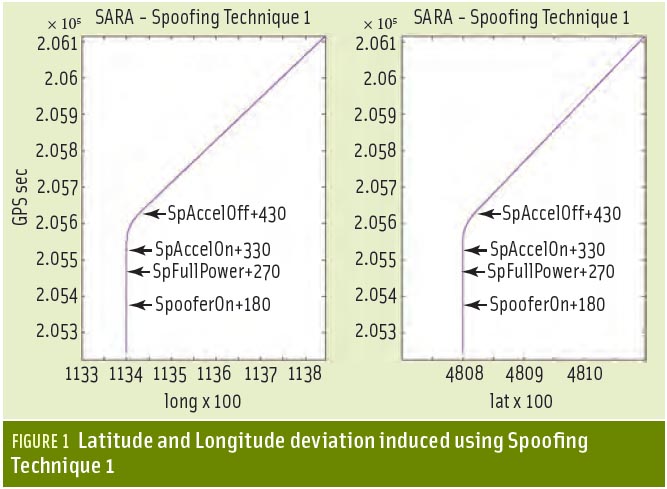
 Logan Scott, LS Consulting
Sometimes GNSS spoofing seems a bit like UFOs: much speculation, occasional alarms at suspected instances, but little real-world evidence of its existence.
As far back as 2001, a U.S. Department of Transportation Volpe Center report suggested that as GPS further penetrates into the civil infrastructure, “it becomes a tempting target that could be exploited by individuals, groups or countries”.
By Inside GNSS
In a part of the world where frustrated drivers will park anywhere, including squarely on a sidewalk, a local newspaper is using location data to shame car owners into shaping up.
The Village, a Russian online publication serving Moscow, St. Petersburg and Kiev; created a free app that notes a badly parked vehicle’s make, color, and license plate information when users snap its picture.
By Dee Ann Divis
 One of 12 magnetograms recorded at Greenwich Observatory during the Great Geomagnetic Storm of 1859
 1996 soccer game in the Midwest, (Rick Dikeman image)
 Nouméa ground station after the flood
 A pencil and a coffee cup show the size of NASA’s teeny tiny PhoneSat
 Bonus Hotspot: Naro Tartaruga AUV
 Pacific lamprey spawning (photo by Jeremy Monroe, Fresh Waters Illustrated)
 “Return of the Bucentaurn to the Molo on Ascension Day”, by (Giovanni Antonio Canal) Canaletto
 The U.S. Naval Observatory Alternate Master Clock at 2nd Space Operations Squadron, Schriever AFB in Colorado. This photo was taken in January, 2006 during the addition of a leap second. The USNO master clocks control GPS timing. They are accurate to within one second every 20 million years (Satellites are so picky! Humans, on the other hand, just want to know if we’re too late for lunch) USAF photo by A1C Jason Ridder.
  Detail of Compass/ BeiDou2 system diagram
 Hotspot 6: Beluga A300 600ST

1. ASHES & AIRPLANES
Boulder, Colorado USA
