Optional Categories Archives - Page 16 of 28 - Inside GNSS - Global Navigation Satellite Systems Engineering, Policy, and Design

Optional Categories

April 28, 2009

Obama Lifts Up GPS in Speech to U.S. Scientists

In his April 27 speech to the National Academy of Sciences (NAS) annual meeting, President Barack Obama twice singled out the Global Positioning System as an example of the need for renewing the U.S. commitment to basic scientific research and education.

“The calculations of today’s GPS satellites are based on the equations that Einstein put to paper more than a century ago,” Obama said, having noted that “no one can predict what new applications will be born of basic research. . . .”

Read More >

By Inside GNSS
April 27, 2009

Companies Announce GPS/Wi-Fi Collaboration

Ekahau Inc. has announced that its Wi-Fi location tracking software is being integrated into GPS receivers designed by NavSync Ltd. to enable customers to continuously track asset in indoor and outdoor environments.

Wi-Fi–enabled GPS tag combines NavSync’s NavTrac GPS module with Ekahau’s location protocol. The NavTrac module incorporates the CW85 16-channel GPS receiver/802.11b/g transmitter combination.

Read More >

By Inside GNSS
[uam_ad id="183541"]
April 26, 2009

Loctronix Gains Patent for Its Spectral Compression Positioning, Tracks CDMA, GNSS

Loctronix SCP technology

[Updated 4/26/09] On March 31, the U.S. Patent Office granted Loctronix Corporation its first patent, which will provide the foundation for its Spectral Compression Positioning (SCP) technology that enables multi-source positioning capability in a single sensor. Subsequently, the company announced that it had successfully achieved meter-level ranging performance using CDMA cellular signals.

Read More >

By Inside GNSS
[uam_ad id="183541"]
April 10, 2009

Air Force Secures ITU Filing with GPS L5 Signal Transmission

Time Series and Power Spectrum of the L5 Demonstration Signal

The GPS IIR-20(M) satellite successfully transmitted for the first time a GPS signal in the L5 frequency band today (April 10), according to the U.S. Air Force operators of the Global Positioning System. L5, the third civil GPS signal, will eventually support safety-of-life applications for aviation and provide improved availability and accuracy to users.

Read More >

By Inside GNSS
April 9, 2009

GPS L5 Signal Goes on the Air April 10

Stanford “Big Dish” Antenna

U.S. Air Force officials are moving quickly to turn on the new civil GPS L5 signal after lengthy delays due to technical problems had brought the program close to an International Telecommunications Union (ITU) deadline for transmitting on the frequency.

The Air Force plans to begin transmitting the signal at 5 a.m. (PDT) on April 10 using the Block II R-20(M) satellite launched March 24. An L5 signal demonstration is planned the same day, organized by the GPS Wing and SRI International. The L5 spectrum will be received and plotted at the SRI’s 150-foot “big dish” antenna facility in the hills over looking Stanford University, California.

Read More >

By Inside GNSS

earthmine Launches 3D Mapping System Driven by GPS, Inertial

John Ristevski

Privacy rebellions such as recently drove a Google Street View crew from Broughton, England, or security-oriented legislation that would require blurred features or position accuracy in commercial imagery is just part of the market environment for 3-D mapping company earthmine, Inc., which is moving out of beta mode into full-fledged operations.

Read More >

By Inside GNSS
March 26, 2009

European Court of Auditors Lambastes Galileo Satellite Navigation Program

European Court of Auditors, Luxembourg

Here’s an interesting document: Preliminary observations on “The management of the Galileo programme’s development and validation phase,” adopted at its January 21–22 meeting by the European Court of Auditors (ECA).

If you’re the kind of person who wakes up in a strange room after a night on the town and wonders how you got there, you’ll want to take in the full 50-page report and six addenda.

Read More >

By Inside GNSS
March 24, 2009

GPS Satellite with L5 Payload Launches Successfully

Block IIR-20(M) launch from Cape Canaveral. Photo by Carleton Bailie, United Launch Alliance.

GPS program managers and users — especially the U.S. civil aviation community — can breathe a sign of relief following the successful launch Tuesday (March 24) of a satellite carrying a demonstration payload of the new L5 signal.

Built by the Lockheed Martin Company, the modernized Block II replenishment spacecraft, GPS IIR-20(M), is moving toward plane B, slot 2 to replace space vehicle number (SVN) 30. If all goes well, U.S. Air Force controllers expect to set the satellite healthy for navigation users worldwide next month.

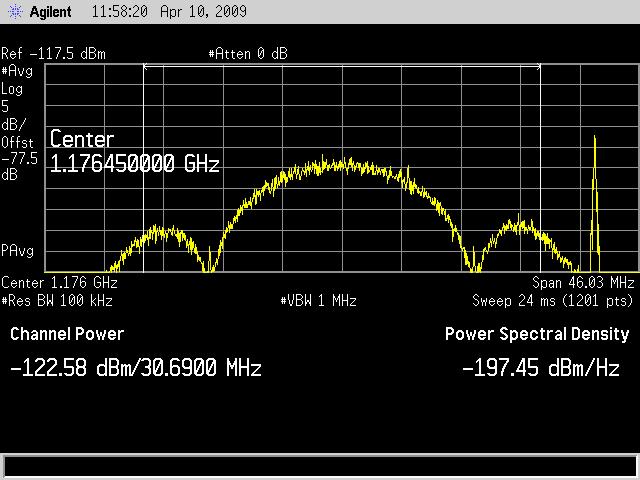
Among other signals and capabilities, the IIR-20(M) will be the first to transmit the new GPS civil signal centered on 1176.45MHz (±12 MHz) within the protected aeronautical radionavigation service (ARNS) band. This so-called L5 signal will provide a second safety-of-life signal that meets the technical requirements for enabling aircraft to make precision landings in high multipath environments.

Read More >

By Inside GNSS
1 14 15 16 17 18 28
IGM_e-news_subscribe