civil

November 27, 2017

Fundamental Rethink for Galileo Commercial Service

At the lavish European Satellite Navigation Competition Awards Ceremony, we caught up with Carlo des Dorides, general director of the European GNSS Agency (GSA), who updated us on the status of the much-anticipated Galileo Commercial Service (CS).

“On the CS, we are dialoging extensively with EU member states, because there is a more and more consolidated view that there could be an advantage to providing the service for free,” des Dorides said.

Read More >

By Peter Gutierrez

Ligado: Business and Network Plan Remain Unclear

A highly anticipated presentation by Ligado Networks to the nation’s leading satellite navigation experts took an unexpected turn when the company said it could not provide essential network information because it was looking to the government for technical direction and its business plans were still in flux.

Read More >

By Dee Ann Divis

Towards Navigation Safety for Autonomous Cars

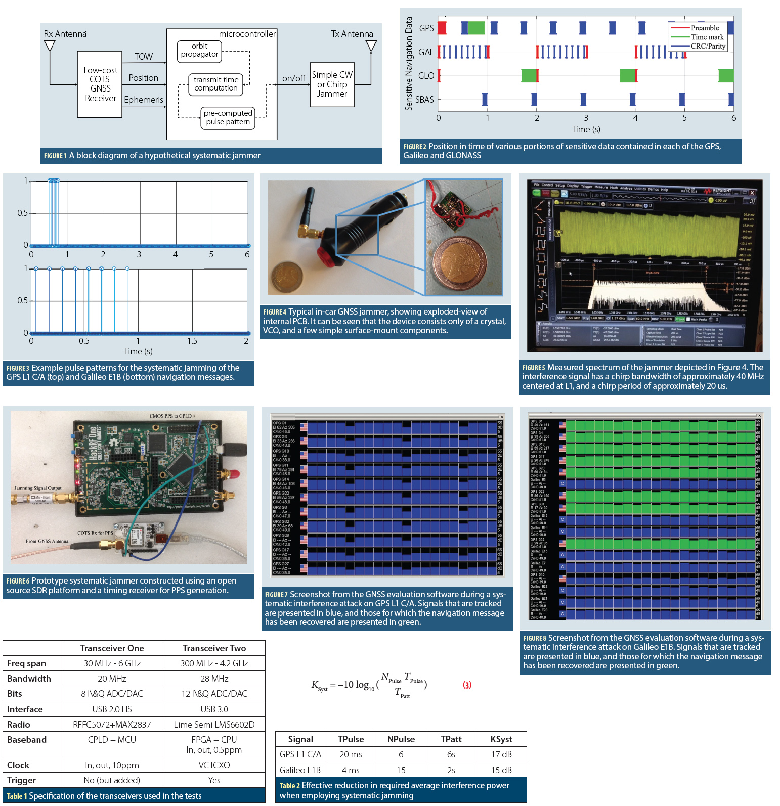
Figures 1 – 6, Table 1

There are many good reasons for getting excited about highly automated vehicles, or HAVs, which is the acronym used by the National Highway Traffic Safety Administration (NHTSA). HAVs can make driving more fuel- and time-efficient. They can significantly reduce traffic congestion and emissions by driving a precise speed, minimizing lane changes, and maintaining an exact distance to neighboring cars. They can also increase accessibility and mobility for disabled and elderly persons.

Read More >

By Inside GNSS
[uam_ad id="183541"]
September 26, 2017

GNSS Hotspots | September 2017

One of 12 magnetograms recorded at Greenwich Observatory during the Great Geomagnetic Storm of 1859
1996 soccer game in the Midwest, (Rick Dikeman image)
Nouméa ground station after the flood
A pencil and a coffee cup show the size of NASA’s teeny tiny PhoneSat
Bonus Hotspot: Naro Tartaruga AUV
Pacific lamprey spawning (photo by Jeremy Monroe, Fresh Waters Illustrated)
“Return of the Bucentaurn to the Molo on Ascension Day”, by (Giovanni Antonio Canal) Canaletto
The U.S. Naval Observatory Alternate Master Clock at 2nd Space Operations Squadron, Schriever AFB in Colorado. This photo was taken in January, 2006 during the addition of a leap second. The USNO master clocks control GPS timing. They are accurate to within one second every 20 million years (Satellites are so picky! Humans, on the other hand, just want to know if we’re too late for lunch) USAF photo by A1C Jason Ridder.
Detail of Compass/ BeiDou2 system diagram
Hotspot 6: Beluga A300 600ST

1. Mangrove Tree-Planting Drones
Myanmar (Southeast Asia)

Read More >

By Inside GNSS

IMO and the GNSS

The maritime sector drives the global economy, with ships transporting more than 80% of world trade. Ships and ports have come to rely on global navigation satellite systems (GNSS) for a huge array of applications relating to position, velocity and precise universal and local time.

Read More >

By Ingo Baumann
[uam_ad id="183541"]
July 28, 2017

How is Public Safety reliant on GNSS and is this a concern?

Q: How is Public Safety reliant on GNSS and is this a concern?

A: Much like many industries and organizations, as the nature of Public Safety grows and evolves, its members have looked to leverage available technologies that help them achieve their goals. In this case, the goals are first and foremost Public Safety followed closely by Member Safety whether it be police, fire or others.

Read More >

By Inside GNSS

Galileo in the Here and Now

No longer consigned to predicting what might one day happen, the folks at the Galileo program can now look at and talk about what is happening right now, starting with initial services. To help us understand what’s going on, we enlisted no less than Matthias Petschke, Galileo Program Director at the European Commission (EC).

Read More >

By Peter Gutierrez
April 9, 2017

GNSS Hotspots | April 2017

One of 12 magnetograms recorded at Greenwich Observatory during the Great Geomagnetic Storm of 1859
1996 soccer game in the Midwest, (Rick Dikeman image)
Nouméa ground station after the flood
A pencil and a coffee cup show the size of NASA’s teeny tiny PhoneSat
Bonus Hotspot: Naro Tartaruga AUV
Pacific lamprey spawning (photo by Jeremy Monroe, Fresh Waters Illustrated)
“Return of the Bucentaurn to the Molo on Ascension Day”, by (Giovanni Antonio Canal) Canaletto
The U.S. Naval Observatory Alternate Master Clock at 2nd Space Operations Squadron, Schriever AFB in Colorado. This photo was taken in January, 2006 during the addition of a leap second. The USNO master clocks control GPS timing. They are accurate to within one second every 20 million years (Satellites are so picky! Humans, on the other hand, just want to know if we’re too late for lunch) USAF photo by A1C Jason Ridder.
Detail of Compass/ BeiDou2 system diagram
Hotspot 6: Beluga A300 600ST

1. ANTARCTIC OASIS
Antarctic Peninsula

Read More >

By Inside GNSS
January 26, 2017

GNSS Hotspots | January 2017

One of 12 magnetograms recorded at Greenwich Observatory during the Great Geomagnetic Storm of 1859
1996 soccer game in the Midwest, (Rick Dikeman image)
Nouméa ground station after the flood
A pencil and a coffee cup show the size of NASA’s teeny tiny PhoneSat
Bonus Hotspot: Naro Tartaruga AUV
Pacific lamprey spawning (photo by Jeremy Monroe, Fresh Waters Illustrated)
“Return of the Bucentaurn to the Molo on Ascension Day”, by (Giovanni Antonio Canal) Canaletto
The U.S. Naval Observatory Alternate Master Clock at 2nd Space Operations Squadron, Schriever AFB in Colorado. This photo was taken in January, 2006 during the addition of a leap second. The USNO master clocks control GPS timing. They are accurate to within one second every 20 million years (Satellites are so picky! Humans, on the other hand, just want to know if we’re too late for lunch) USAF photo by A1C Jason Ridder.
Detail of Compass/ BeiDou2 system diagram
Hotspot 6: Beluga A300 600ST

Tracking illegal logging in Romania, autonomous mining, ancient calendars and Canadian cows

Read More >

By Inside GNSS
January 23, 2017

Positioning Technology in Australia Gets a $12 Million Boost

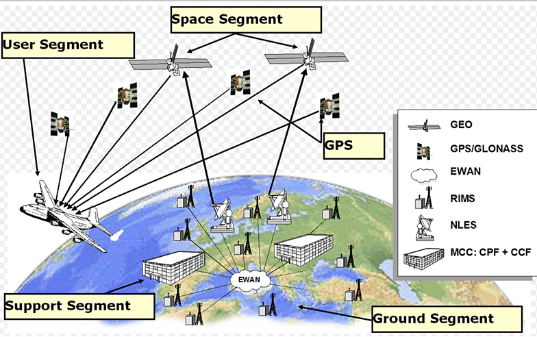
SBAS illustration with the GNSS satellites (upper left) and the communications satellite (upper right).

With the Australian government’s announcement earlier this month that it would invest $12 million in a two-year program looking into the future of positioning technology in Australia, comes plans for testing of satellite based augmentation systems (SBAS) to be undertaken, and for future applications for all four major modes of transport in Australia, as well as for potential safety, productivity, efficiency and environmental benefits.

Read More >

By Inside GNSS
1 2 3 9
IGM_e-news_subscribe