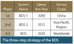
The BeiDou Navigation Satellite System (BDS) is China’s contribution to the world in the domain of Global Satellite Navigation System (GNSS). The BDS is being developed by the Chinese government, mainly through military departments, with key considerations for China’s national security, economic interests and social progress.
By Ingo BaumannGNSS & The Law delves into the debates and developments around the new area of global satellite navigation system law.
This occasional feature by guest writers is coordinated by Ingo Baumann, co-founder and partner of BHO Legal in Cologne, Germany. His practice focuses on European high technology projects mainly in the space sector.
By Ingo BaumannThis year India entered the club of nations operating their own satellite navigation system. The Indian Regional Navigation Satellite System (IRNSS) has a constellation of seven satellites – three in geostationary orbit and four in geosynchronous orbit — that are currently functioning satisfactorily from their designated orbital positions.
By Ingo BaumannReasonable Expectations of Privacy and a discussion of privacy in the United States typically begins with the Fourth Amendment of the U.S. Constitution, which provides that “[t]he right of the people to be secure in their persons, houses, papers, and effects, against unreasonable searches and seizures, shall not be violated.” In U.S. v Katz, the U.S. Supreme Court found that this Fourth Amendment protection created an individual’s constitutional right to privacy.
By Ingo BaumannJapan’s regional and augmentation positioning system, the Quasi-Zenith Satellite System (QZSS), is a project yet to be developed. While it will become a constellation of seven satellites covering the western Pacific area, only “Michibiki,” the first satellite launched in 2010 for technological validation , is now in orbit.
By Ingo BaumannThe legal and regulatory framework of the Russian Federation covers not only the GLONASS system, but the country’s overall positioning, navigation and timing (PNT) system as well.
The term PNT is a synonym for navigation activities as defined in the Federal Law on Navigation Activities. The PNT system in the Russian Federation is defined as the combination of administrative and technical means that provide spatial and time data to all user groups, with GLONASS as a key element.
By Ingo BaumannGlobal navigation satellite systems have become core elements of the global economy. Essential for many civilian applications and innovations, GNSS brings rapidly growing economic benefits due to convergence of GNSS with smartphones, geospatial data, unmanned aerial vehicles, automated driving systems and other commercial technologies.
By Ingo BaumannThe availability of several GNSSes promises advanced positioning, navigation, and timing services with higher availability and improved accuracy. According to a European GNSS Agency (GSA) market study, nearly 60 percent of receivers, chipsets, and modules already support at least two GNSS constellations, showing that multi-constellation is becoming a standard feature across all market segments. That development brings up questions of law and regulation that require careful handling by GNSS manufacturers, service providers, and policy makers.
By Ingo Baumann