December 8, 2020
New Multi-GNSS+Inertial Positioning Solution for Nearshore Environment
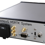
Hexagon | NovAtel has released the new MarinePak7 GNSS+inertial receiver that delivers precise positioning and timing for demanding nearshore marine applications. It is certified for the marine environment and designed for hydrographic survey, marine construction and nearshore renewable energy operations.
By Inside GNSS