September 13, 2019
Septentrio Introduces AsteRx SBi GNSS/INS System in a Rugged Housing
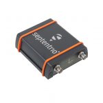
Leuven, Belgium-based Septentrio, a global supplier of high-accuracy positioning technology for demanding applications, unveiled this week AsteRx SBi, a new housed GNSS/INS receiver. Within its rugged, waterproof enclosure a high-performance GPS/GNSS is coupled with an industrial-grade inertial sensor to provide high-accuracy, reliable positioning and 3D orientation (heading, pitch, roll).
By Inside GNSS