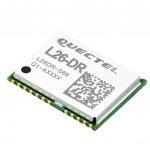
Autonomous Vehicles Archives - Page 14 of 18 - Inside GNSS - Global Navigation Satellite Systems Engineering, Policy, and Design

Autonomous Vehicles

September 28, 2017

Honey Shares his Lifetime of Navigation with Boats, Cars and Sports During Keynote Speech

As a child Stan Honey taught himself navigation and he admits he was “always good at math” and “just found navigation interesting.”

When he shared his many tales with the crowd in the Oregon Ballroom Tuesday night at the ION GNSS+ during the Plenary Session, the Yale- and Stanford-trained engineer entertained the audience with a wealth of information on early navigation systems, current navigation technologies, and how he and his colleagues developed many of the systems used to enhance the way millions of fans watch sports on television.

Read More >

By Inside GNSS
September 22, 2017

Spirent Partners with Cranfield University on Autonomous Vehicle Technology 

Spirent’s GSS7000 Series of Multi-GNSS, Multi-frequency Simulators. Photo: Spirent.

Spirent Communications plc, a leader in Galileo, GPS and other global navigation satellite systems (GNSS) testing solutions, this week announced a partnership with Cranfield University, a global leader for education and transformational research in technology and management. The two organizations will be collaborating to develop connected autonomous vehicle (CAV) technologies.

Read More >

By Inside GNSS
September 8, 2017

SaPPART COST Action – Final Conference

The COST Action SaPPART on “Satellite Positioning Performance Assessment for Road Transport” will conduct its final conference at Blue Point Brussels in early October. At this occasion, attendees will learn more on the role of accurate positioning within the context of autonomous driving. This event will be jointly organized with ERTICO.

Read More >

By Inside GNSS
[uam_ad id="183541"]
August 8, 2017

Autonomous Vehicles Detroit: Shaping the Future of Society

Autonomous Vehicles Detroit brings together the leading engineers, innovators, and executives driving the future of autonomy.

Questions to be addressed include:
• How do you imagine the future of mobility?
• How will mobility be shaped by the next generation of…
ADAS
Artificial Intelligence
Sensors & Mapping Systems
Connectivity
• What types of challenges do you envision for society as a whole regarding…
Regulatory Hurdles
Liability/Insurance
Consumer Acceptance

Read More >

By Inside GNSS
June 30, 2017

Applanix, University of Waterloo Collaborate on Advanced Technologies for Autonomous Vehicles

Applanix will provide WatCAR with its POS for testing autonomous guidance and control systems in real-world conditions. Photo source: Applanix.

Applanix, a Trimble Company, announced this week that it is collaborating on advanced research for autonomous vehicle guidance and control systems with the University of Waterloo Centre in Ontario, Canada for Automotive Research (WatCAR). Applanix will provide WatCAR with its Positioning and Orientation System (POS) for testing autonomous guidance and control systems in real-world conditions. Applanix will also provide the Trimble GNSS-Inertial board set for integration with car systems and sensors to enable precise positioning.

Read More >

By Inside GNSS
[uam_ad id="183541"]
June 4, 2017

GNSS Hotspots | June 2017

One of 12 magnetograms recorded at Greenwich Observatory during the Great Geomagnetic Storm of 1859
1996 soccer game in the Midwest, (Rick Dikeman image)
Nouméa ground station after the flood
A pencil and a coffee cup show the size of NASA’s teeny tiny PhoneSat
Bonus Hotspot: Naro Tartaruga AUV
Pacific lamprey spawning (photo by Jeremy Monroe, Fresh Waters Illustrated)
“Return of the Bucentaurn to the Molo on Ascension Day”, by (Giovanni Antonio Canal) Canaletto
The U.S. Naval Observatory Alternate Master Clock at 2nd Space Operations Squadron, Schriever AFB in Colorado. This photo was taken in January, 2006 during the addition of a leap second. The USNO master clocks control GPS timing. They are accurate to within one second every 20 million years (Satellites are so picky! Humans, on the other hand, just want to know if we’re too late for lunch) USAF photo by A1C Jason Ridder.
Detail of Compass/ BeiDou2 system diagram
Hotspot 6: Beluga A300 600ST

1. RESCUE DRONE
Noordwijk, Netherlands
√ Inspired by the refugee crisis, Dutch start-up Avy has been working on robust, long-duration drones capable of detecting people in distress and, if necessary, dropping life jackets, life buoys, food and medicine. The rescue drone can take off from a boat or the shore, carrying among other items, a cylinder that contains a large deployable rescue buoy, which not only can keep refugees afloat but indicates its location to boats in the vicinity.

Read More >

By Inside GNSS
May 31, 2017

Ligado Focuses on Unmanned Sector in Push for Terrestrial Network

The Virginia firm that had been hoping to use satellite frequencies near the GPS band to support a terrestrial broadband network has changed its pitch to regulators. Ligado, previously named LightSquared, is working to convince the Federal Communications Commission (FCC) that its frequencies are the way to provide connectivity to the broad internet of things (IoT) including unmanned aircraft, driverless cars and other unmanned systems.

Read More >

By Dee Ann Divis
May 15, 2017

Swift Navigation and Carnegie Announce First Joint Product

Swift Navigation and Carnegie Robotics (CRL) rolled out their first joint product, a real-time kinematic (RTK) GNSS receiver called Duro, at the AUVSI XPONENTIAL trade show in Dallas, Texas, May 8-11.

The companies say Duro is targeted to robotics, precision agriculture, mapping, military, outdoor industrial and maritime markets.

Read More >

By Inside GNSS
May 14, 2017

Hemisphere GNSS Announces New Vector Eclipse H328 OEM Positioning and Heading Board

Vector Eclipse H328. Photo source: Hemisphere GNSS.

Hemisphere GNSS announces the Vector Eclipse H328, the next offering in a line of new and refreshed, low-power, high-precision, positioning and heading OEM (original equipment manufacturer) boards. The multi-frequency, multi-GNSS H328 is an all signals receiver board that includes Hemisphere’s new hardware platform and integrates Atlas GNSS Global Correction Service.

Read More >

By Inside GNSS
March 31, 2017

Swift Navigation, Carnegie Robotics Partnership to Yield High-Precision GNSS, Inertial Technology Products

Swift Navigation CTO Fergus Noble, left, and Carnegie Robotics CTO Chris Osterwood, right. Photo source: Swift Navigation.

A partnership between Swift Navigation and Carnegie Robotics announced this week is expected to yield a line of navigation products for autonomous vehicles, outdoor robotics and machine control.

San Francisco-based Swift Navigation is a startup building centimeter-accurate GPS technology designed to power a world of autonomous vehicles, while Carnegie Robotics, located in Pittsburgh, Pennsylvania, provides advanced robotics sensors and platforms for defense, agriculture, mining, infrastructure and energy applications.

Read More >

By Inside GNSS
1 12 13 14 15 16 18
IGM_e-news_subscribe