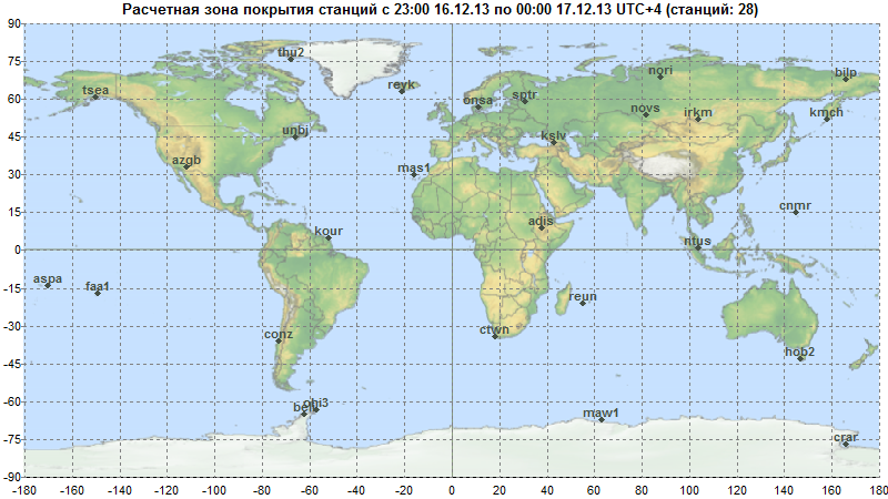
A: System Categories

Sixth Conference on European Union Space Policy

The 6th Conference on European Union Space Policy will take place at the European Commission’s Charlemagne Building, in Brussels, Belgium on January 28 and 29, 2014.

Registration is now open. Online registration closes January 22, 2014.

The theme is "What Direction for Europe in Space Between Now and 2020?." The conference is sponsored by the presidents of the European Commission, the European Council and the European Parliament.

Read More >

By Inside GNSS
[uam_ad id="183541"]

GSA Invites Proposals for European GNSS R&D Projects

Horizon 2020 (H2020), the new incarnation of European Commission–funded research and innovation programs, has issued its first call for applications in satellite navigation.

The relatively modest — €38 million (US$52 million) out of a total of  €70 billion (US$92 billion) for the period 2014–2020 — represents an initial round of invitations for R&D proposals that previously were distributed under the framework programs (FPs). The deadline for submitting proposals is April 3, 2014.

Read More >

By Inside GNSS
November 30, 2013

GNSS Hotspots | November 2013

One of 12 magnetograms recorded at Greenwich Observatory during the Great Geomagnetic Storm of 1859
1996 soccer game in the Midwest, (Rick Dikeman image)
Nouméa ground station after the flood
A pencil and a coffee cup show the size of NASA’s teeny tiny PhoneSat
Bonus Hotspot: Naro Tartaruga AUV
Pacific lamprey spawning (photo by Jeremy Monroe, Fresh Waters Illustrated)
“Return of the Bucentaurn to the Molo on Ascension Day”, by (Giovanni Antonio Canal) Canaletto
The U.S. Naval Observatory Alternate Master Clock at 2nd Space Operations Squadron, Schriever AFB in Colorado. This photo was taken in January, 2006 during the addition of a leap second. The USNO master clocks control GPS timing. They are accurate to within one second every 20 million years (Satellites are so picky! Humans, on the other hand, just want to know if we’re too late for lunch) USAF photo by A1C Jason Ridder.
Detail of Compass/ BeiDou2 system diagram
Hotspot 6: Beluga A300 600ST

1. PAPER, PLEASE.
Silver Spring, Maryland USA
√ The USA will stop printing nautical charts next April, the end of a 150 year tradition. Why? “Declining demand, electronic and digital charts and federal budget realities,” said NOAA’s Office of Coast Survey. They will maintain and update PDFs of more than a thousand coastal charts and refer those who admire traditional lithography to private printers who can do the job.

Read More >

By Inside GNSS
November 27, 2013

Auto Regulators Seek to Shape Navigation Devices and Apps

Highway safety officials are crafting guidelines aimed at pushing manufacturers to make portable electronic devices — including cell phones, hand-held navigation receivers, and navigation apps — less likely to distract drivers. They may face some push back, however, from members of Congress who are already questioning whether GNSS devices should be included under the proposed standards.
 

Read More >

By Inside GNSS
[uam_ad id="183541"]

China Satellite Navigation Conference 2014 Planned for Nanjing

Academician Sun Jiadong, Chairman of CSNC 2014

The organizing committee for the fifth China Satellite Navigation Conference (CSNC 2014) is inviting papers for presentation at the event, scheduled May 21–23 in Nanjing.

The annual event is China’s largest and most comprehensive high-level satellite navigation academic conference. Abstracts need to be submitted by November 30 and full papers, by December 30.

Read More >

By Inside GNSS
November 19, 2013

RF Spectrum Protection

Jules McNeff, Overlook SystemsTechnologies, Inc.

EDITOR’S NOTE: Jules McNeff answers additional questions on the subject of spectrum protection and sharing in a special “GNSS Forum” extension of this installment of the "Thought Leadership Series" in this issue of Inside GNSS.

As Mark Twain once famously told a petitioner for investment advice: “Buy land. They are not making it any more.”

So it is with radio frequency spectrum, a limited and finite resource.

Read More >

By Inside GNSS
November 18, 2013

Questions in Wake of New Galileo Delay

Some of the specific technical issues behind the latest delay for Galileo’s first full operational capability (FOC) satellites have already been reported. The story, as it is told, generally starts with a late navigation payload delivery by British firm Surrey Satellite Technology to the German prime contractor, OHB. Next, OHB ran into issues with the payload and the platform, further stretching out the timeline.

Read More >

By Peter Gutierrez

Integrated Navigation

GPS/BeiDou/MEMS configuration and GPS/MEMS configuration (left and right, respectively, top photo), Front view (center photo) and back view (lower photo) of nAX5.2

Due to the huge success of GPS in both military and civil applications, several other GNSSs have been developed, built, and operated in the last few decades. GNSS, regional, and augmentation systems are comprise a growing family that also includes GLONASS, Galileo, BeiDou, and Japan’s Quasi-Zenith Satellite System (QZSS). New members, such as the Global Indian Navigation System (GINS), are preparing to join in next decade.

Read More >

By Inside GNSS
IGM_e-news_subscribe