Advanced Navigation Supplies Rheinmetall Defense Australia with Inertial Navigation Solution
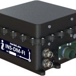
Advanced Navigation, a provider of assured positioning navigation and timing (APNT) technologies and autonomous systems, has finalized a multi-million dollar deal with Rheinmetall Defense Australia to supply fiber-optic gyroscope (FOG) inertial navigation systems (INS), for integration into Rheinmetall’s Boxer Combat Reconnaissance Vehicles (CRV), currently in service with the Australian Army.
By Inside GNSS