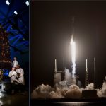
GPS Archives - Page 18 of 138 - Inside GNSS - Global Navigation Satellite Systems Engineering, Policy, and Design

GPS

March 26, 2020

2SOPS Takes Charge of GPS III 01; Watch Space Ballet

The Second Space Operations Squadron (2SOPS) at Schriever Air Force Base, Colorado officially took control of the second GPS III satellite in orbit on March 23. GPS III SV02 was designed and built by Lockheed Martin, with a payload provided by L3Harris.

A video rendering of a GPS III satellite gives a slightly vertigo-inducing experience of a ballet through space and above the Earth.

Read More >

By Inside GNSS
March 24, 2020

Ship-tracking Microsatellites Could Spot GPS Jammers from Space

A satellite firm now offering ship monitoring and tracking is studying whether it can use its new, formation-flying satellites to pinpoint GPS jammers and potential interference.

Virginia-based HawkEye 360 has had three microsatellites flying in sun-synchronous, polar orbit since early 2019. The Hawk satellites can detect radio frequency transmissions from the Earth’s surface and, by working as a coordinated cluster, independently determine the location of the source. They are currently being used to detect transmissions from the Automatic Identification System (AIS) devices ships are required to carry and independently geolocating the source so the reported and actual location of the ship can be compared and reported. The system can locate a transmitter with an accuracy of 500 meters depending on the signal. That could improve as HawkEye builds out its constellation.

The firm is already committed to putting another five clusters into space by the end of 2021 and HawkEye CEO John Serafini told Inside GNSS, there are plans to launch an additional cluster by mid 2022. Funding is in hand for the additional satellites thanks to a Series B round of financing completed earlier this year. With seven clusters of satellites in orbit the return rate — that is frequency with which a satellite will be flying overhead the same spot on Earth — will jump from about once every five hours to once roughly every 30 minutes, Serafini said.

Each satellite cluster flies in formation, a capability enabled by a specially designed propulsion system. Their software-defined radios are able to tune into frequencies ranging from 144 MHz to 15 GHz (approximately VHF to Ku-Band). To be detected from space the signal power on the ground has to be 1 watt or more.

“Generally speaking if the signal is above a watt in power — between 150MHz and 15 GHz — we can detect it and we can geolocate, process and analyze that signal,” Serafini said. Over the first 14 months of operation, Cluster 1 detected 11 million independent geolocations of various signals.

All this capability comes in pretty small packages. The initial three satellites weigh just 15 kg each. Starting with Cluster 2 that will jump to 25 to 28 kg each.

The firm’s originally targeted market leaned toward services for defense, intelligence and security applications. Now HawkEye is assessing offering a new service that would identify the location of GPS jammers.

“GPS jamming is on our product roadmap,” said Serafini and the company hopes to be able to offer the service in approximately six months. “We have to evaluate the opportunity and develop a product.”

It’s entirely plausible that HawkEye’s satellites could locate GPS jammers, according to Logan Scott of LS Consulting, an expert on both navigation and telecommunication signals. Scott said he’d been introduced to the technology a couple of years ago at a presentation and, though he’s not done a link analysis, believes it has potential for such a capability. “If it’s a big jammer. Yeah, I could definitely see something like that — there are some neat things you can do.”

It might also be possible to gain insight into spoofing, albeit indirectly. AIS data already has been used in this way by other organizations. If the AIS location data, for example, indicates that ships are traversing dry land, that strongly suggests spoofing.

Hawkeye might be able to do something similar based on other modes of transportation like trucks and trains. If there is publically available location data being transmitted by a truck or other asset, the satellites are capable of receiving those signals directly, said Serafini. Alternatively the firm could use data from a third party provider. If the reported location and the actual location don’t match that could be the result of spoofing.

“We have not done that yet,” said Serafini, “but we would, and we think there are databases that are commercially available that we could purchase depending on what the asset is that wants to be tracked.”

HawkEye could even map such disruptions over time. This might have been useful in the case of the truck driver whose GPS-jamming personal privacy device disrupted the ground-based augmentation system (GBAS) at the Newark Liberty International Airport in Newark, New Jersey when he drove past. The intermittent disruptions were a puzzle at the time.

The system may also be able to gather enough data to determine if signals in bands near those used by GPS could be interfering with GPS receivers. GPS users have most recently faced this possibility from a proposal by Ligado Networks, which wants to use satellite frequencies neighboring those used by GPS for a terrestrial service. With signal frequency, power and location data from the HawkEye system it could be possible to determine if Ligado signals were interfering with GPS equipment.

One of the challenges in doing that though, said Scott, would be identifying a particular transmitter that might be creating problems — especially if that transmitter is part of a network with other nearby transmitters. This is further complicated by the fact that communication transmitters aim most of their power at the ground.

“I don’t want to say impossible,” said Scott. “I don’t want to shortchange what these guys can do; they’re a very capable group. But at the same time, I’m trying to be cautious in my assessment.”

HawkEye is still engaged in its analysis it is too soon for additional detail about the potential for such a capability.

Scott suggested that HawkEye might be able to create a heat map that shows signals and their power at various geographic locations. “The heat map would be indicative of whether or not, in that area, you could expect to see problems.”

Serafini said they already have such a service.

“One of the products that we offer today is RFMosaic that looks at a specific geographic location and time and frequency range and maps the signals of interest that we see — the spectral energy in that area.”

RFMosaic includes features to help identify changes in RF activity over time and identify potential sources of interference, according to the company’s website.

Art courtesy of Hawkeye 360

By Dee Ann Divis
[uam_ad id="183541"]

CRPAs Protect Critical Infrastructure: How to Test

Since 2015, controlled reception pattern antennas (CRPAs) have come onto the market for civil applications where the need to counter increasing  GNSS signal jamming and spoofing has grown exponentially. Highly classified and previously available only to authorized military users, these powerful — and unfamiliar — components expand protection for critical infrastructure. All systems incorporating them should be tested for revamped vulnerabilities. This is how.

A free webinar on Wednesday, March 25 from 1:00 PM – 2:30 PM Eastern Daylight Savings Time addresses the topic “GNSS Vulnerability Testing and the Controlled Reception Pattern Antenna (CRPA).”

Read More >

By Inside GNSS

NEON for GPS-denied Environments Marches with Army, DOT

The U.S. Army’s Rapid Capabilities and Critical Technologies Office’s (RCCTO) selected TRX Systems to deliver a prototype tactical electronic warfare (EW) kit for dismounted soldiers. TRX is also one of 11 firms selected by the Department of Transportation to demonstrate GPS backup technologies, with tests to take place in March.

[This story is the third in a series of 11 detailing technology from firms selected by the Department of Transportation (DOT) in August 2019 to demonstrate technologies that could be used to back up the services provided by GPS should GPS signals be jammed, spoofed or unavailable.  See also Echo Ridge and Seven Solutions.]

TRX Systems will provide a portable kit that generates alerts when electronic jamming or spoofing is detected and will provide a “rewind” navigation feature to estimate the user’s probable current position after jamming or spoofing has occurred. The company has developed NEON, a GPS-denied location technology, providing 3D mapping and GPS-denied personnel tracking for warfighters, first responders, security and industrial personnel that operate indoors, underground, and in areas without GPS.

Neon Command User Interface. Courtesy TRX Systems

NEON delivers ubiquitous, low-cost, GPS-denied location through the use of advanced sensor fusion, ranging, and patented dynamic mapping algorithms. The algorithms fuse inertial sensor data, Wi-Fi readings and inferred building data to deliverreliable 3D location. Optional use of geo-referenced ultra-wideband or Bluetooth beacons enhances positioning accuracy

Neon User Interface. Courtesy TRX Systems

TRX’s NEON Location Service provides position data that enables tracking and navigation when satellite technology is unavailable or unreliable. NEON detects GPS interference and delivers continuous location during such events; NEON also delivers 3D personnel location indoors, outside, and underground. NEON provides PNT assurance with commercial-grade solutions that integrate with present and future military satellite assurance and location capabilities.

“The EW Kits provide an easy to use and real-time assessment of GPS integrity for the warfighter, integrated with existing military applications and systems,” said Carol Politi, President and CEO of TRX Systems.

In a 2017 case study, TRX Systems’ NEON Personnel Tracker solution provided 3D tracking of law enforcement, EMS Personnel and other first responders during a critical incident training exercise at Grand Central Terminal in New York City, hosted by the Department of Homeland Security (DHS).

Bottom Image (4th Image)
Courtesy TRX Systems


By Inside GNSS
March 20, 2020

When Truth Matters. Absolutely.

One may well ask, when doesn’t it?

That aside, some controversy has arisen in the world of competitive running, and self-competitive running as in Personal Bests, or PBs. Runners find their fitness trackers and watches don’t necessarily tell them the truth in terms of distance travelled. In fact, they very rarely tell the absolute truth. Which matters.

Read More >

By Alan Cameron
March 13, 2020

Signal Vulnerability.

Previously, controlled reception pattern antennas (CRPAs) were only in the military domain, and highly classified. The need to counter increasing  GNSS signal jamming and spoofing in the civil realm has brought CRPAs into limited use there as well.  How to test for their efficacy in product design and development?

A free webinar on Wednesday, March 25 from 1:00 PM – 2:30 PM Eastern Daylight Savings Time addresses the topic “GNSS Vulnerability Testing and the Controlled Reception Pattern Antenna (CRPA).” This technically rich, educational event is sponsored by Spirent Communications and Inside GNSS.

Read More >

By Inside GNSS
[uam_ad id="183541"]

U2: BeiDou Is My Co-pilot

According to a statement by the head of U.S. Air Force Air Combat Command, pilots of the elite U-2 spy plane wear watches that receive foreign GNSS signals and provide backup navigation when GPS is jammed.

“My U-2 guys fly with a watch now that ties into GPS, but also BeiDou and the Russian [GLONASS] system and the European [Galileo] system so that if somebody jams GPS, they still get the others,” said Gen. James “Mike” Holmes on March 4 at the McAleese Defense Programs Conference in Washington.

The Lockheed U-2, nicknamed “Dragon Lady,” is a single-jet engine, ultra-high altitude (70,000 feet, 21,300 meters) reconnaissance aircraft. It gathers intelligence with a variety of sensors. The U-2 is one of very few aircraft that have served the Air Force for more than 50 years, a select group that also includes the B-52 long-range bomber. The latest model, the U-2S, had a technical upgrade in 2012. [Dragon Lady photo above, courtesy Lockheed.]

Gen. Holmes did not name the watch manufacturer.

In February 2018, Garmin announced that its D2 Charlie aviator watch had been selected by the Air Force  for use by the pilots of the Lockheed U-2 aircraft. “The high-sensitivity WAAS GPS-enabled D2 Charlie aviator watch incorporates global navigation capability, rich and colorful moving maps and more, providing pilots in the USAF with an exclusive, back-up navigation timepiece in the cockpit. . . . The D2 Charlie aviator watch will be an integral and functional part of the U-2 pilot’s toolkit.”

According to the press release, Garmin expected the United States Air Force to take delivery of more than 100 D2 Charlies.

Among the sensors mentioned on Garmin’s spec sheet for the watch are GPS, GLONASS, a heart rate monitor, barometric altimeter, compass, accelerometer and thermometer. BeiDou is not listed.

However, in an annual report filed with the Securities and Exchange Commission, the company stated: “Garmin utilizes a variety of other global navigation satellite systems (GNSS) including, but not limited to . . . .The BeiDou Navigation Satellite System (BDS), a Chinese satellite navigation system that is expected to have 35 operating satellites in orbit by 2020 and will provide global coverage.”

Charlie
Garmin’s D2 Charlie watch, shown here with Weather radar overlay feature. Photo: Garmin

D2 Charlie has a sapphire scratch-resistant crystal lens and a diamond-like carbon (DLC) coated titanium bezel. A sunlight-readable, high-resolution color display with LED backlight on the watch face allows pilots to view data in most lighting conditions in the cockpit. It offers up to 20 hours of battery life in GPS mode and up to 12 days in smartwatch mode. It comes with a leather wristband and a sporty silicone band.

By Inside GNSS
March 3, 2020

Air and Space Forces Want $100s of Millions More for GPS-related Priority Projects

When the White House submits its budget request for the Department of Defense to Congress every year, that is not the final word. The different military services also send Congress their unfunded priority lists, which detail the projects the White House chose to forego but, the services hope, Congress will add back in. This year several of those priorities are GPS-related.

Read More >

By Dee Ann Divis
1 16 17 18 19 20 138
IGM_e-news_subscribe