Air Traffic Control Modernization: FAA, NextGen, GNSS, and Avionics Equipage
Mike Dyment, General Partner, NextGen Equipage Fund LLC» Air Traffic Control Modernization (PDF)
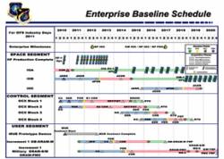
In between partisan confrontations around the 2011 federal budget and raising the U.S. debt limit, prospects are improving for federal legislation that would provide the Federal Aviation Administration (FAA) with a regular full-year budget for the first time since Fiscal Year 2007 — including support for completing the transition to a GNSS-driven air traffic control (ATC) system known as NextGen and a “public-private partnership” to equip aircraft with the needed avionics.
By Inside GNSS