After detailing the highs and lows of Galileo’s development in the first Inside Galileo column, the second installment looks back on negotiations between the U.S. and the EC, with the two resulting agreements helping to shape Galileo while also leaving a lasting imprint on the global GNSS landscape.
he Galileo satellite navigation program required far more than engineering ingenuity to reach operational status. Among the most consequential challenges facing the European Commission (EC) was securing internationally recognized radio frequency allocations—and, critically, the negotiation of compatibility and interoperability arrangements with the United States’ Global Positioning System (GPS). The main reason for that: The L-band was almost fully occupied.
This column chronicles the full arc of those consultations, from the early work of the EC Signal Task Force through four years of intensive EC-U.S. bilateral dialogue, culminating in two landmark agreements.
Compatibility and Interoperability
These two terms stood at the center of every meeting, every technical analysis, and every diplomatic exchange throughout the GPS-Galileo process. Their precise meaning was not merely semantic: The definitions determined what obligations each party had accepted and what performance guarantees users could expect.
Compatibility: The ability of GPS and Galileo services to be used separately or together without one system causing unacceptable interference to the other system and without other satellite navigation systems causing unacceptable interference to GPS and Galileo.
In technical terms, compatibility analysis asks: When both constellations transmit simultaneously in overlapping frequency bands, does the aggregate interference power remain below a threshold that degrades each system’s effective carrier-to-noise density ratio (C/N₀) by more than an agreed maximum? At that time, the International Telecommunication Union (ITU) did not show a number for a Medium Earth Orbit (MEO) signal, only for Geostationary Earth Orbit, or GEO, (0,3 dB). The threshold negotiated between the European Commission and the United States for the shared E1/L1 band centered at 1,575.42 MHz was a C/N₀ degradation not exceeding 0.1 dB for the worst-case user scenario.
Achieving compatibility required detailed modeling of the interference environment. Key parameters included the number of visible satellites from each constellation, the transmitted signal power levels, and the spectral separation coefficients between competing signals. The frequency spectrum revealed only very small unoccupied slots of 4 MHz in the L-band. Because the ranging performance of a signal is proportional to its bandwidth, Galileo never could have achieved an accuracy comparable to GPS. Although new research at the European Space Agency (ESA) demonstrated approximately 50% higher accuracy could be extracted from these small 4 MHz slots than the bandwidth-proportionality rule would predict, it still could not match the accuracy of GPS. This prompted intensive research into how to place new modulations onto existing and partly occupied L-band slots, thereby achieving compatibility.
Interoperability: The ability of global and regional navigation satellite systems and augmentations to be used together to provide better capabilities at the user level than would be achieved by relying solely on one system or signal.
Where compatibility is essentially a constraint—a requirement not to cause harm— interoperability is an aspiration: the positive design goal of enabling combined GPS-Galileo receivers to outperform either system alone. The practical manifestation of interoperability in the E1/L1 band is signal design. If GPS and Galileo transmit signals with a common power spectral density (PSD) structure at the same center frequency of 1,575.42 MHz, a single receiver correlator can track both signals without requiring fundamentally different hardware for each. Interoperability thus drives down the cost of multi-constellation receivers, accelerates market adoption, and ultimately benefits users worldwide by providing more ranging observations, improved dilution of precision (DOP) geometry, and enhanced integrity monitoring.
Studies conducted during the negotiation process estimated that dual-constellation receivers could achieve positioning accuracy improvements of 25% to 40% compared to single-constellation receivers in degraded signal environments such as urban settings. We found that an attractive feature for all users and looked to achieve interoperability with all satellite navigation systems providers. However, there is one drawback that may impact the signal acquisition of the receivers: The noise floor is increasing!
The EC Signal Task Force
As Galileo transitioned from political ambition to technical design in 2001 to 2002, the European Commission established the EC Signal Task Force (STF) to define the system’s signal architecture. The Task Force operated at the intersection of signal engineering and international telecommunications law, bringing together experts from the ESA, national agencies, universities and industry. Its mandate covered the selection of modulation schemes, center frequencies, bandwidth allocations, and power levels for all planned Galileo signals across the E5a (1,176.45 MHz), E5b (1,207.14 MHz), E6 (1,278.75 MHz), and E1 (1,575.42 MHz) frequency bands.
The Task Force’s primary regulatory obligation was to comply with ITU Radio Regulations, which require that newly deployed systems demonstrate non-interference with existing allocations and submit frequency coordination requests before commencing transmissions. For Galileo, the relevant ITU filings covered the frequency bands assigned to the Radio Navigation Satellite Service (RNSS). Within this framework, two immediate objectives dominated the Task Force’s early work: securing frequency rights through actual signal transmissions before the ITU “bring into use” deadline, and developing the analytical tools needed to assess compatibility with GPS.
The STF brought excellent experts from European nations together. From the human point-of-view, friendships developed through the many meetings complemented by corresponding national research and exchange between the research organizations. Nevertheless, occasionally harsh arguments were exchanged between the UK and the French representatives. I am grateful to the DLR for supporting that research at my university, the Institute of Geodesy and Navigation.
GIOVE-A and GIOVE-B
Under ITU Radio Regulations Article 11, a frequency notification lapses if the notified system fails to bring the relevant frequencies into use within prescribed deadlines. At the time of Galileo’s filing, this period was seven years from the date of receipt of the coordination request. For Galileo’s most critical filings, the deadline fell in 2006. Failure would have stripped Europe of its priority rights in the E1, E5 and E6 bands, potentially forcing a fundamental redesign of the system’s signal plan. Galileo In-Orbit Validation Element A (GIOVE-A), built by Surrey Satellite Technology Ltd, was launched on December 28, 2005, from the Baikonur Cosmodrome.
GIOVE-A was never intended as a navigation satellite in the operational sense. Its primary mission was regulatory: transmit Galileo signals in the E1, E5a, E5b and E6 frequency bands before the ITU deadline expired, thereby preserving Europe’s priority rights to those allocations. GIOVE-A began transmitting on January 12, 2006—just in time—and continued to operate until July 2012, accumulating a signals-in-space dataset of enormous value for signal design and interference analysis.
GIOVE-B followed on April 27, 2008, launched by a Soyuz rocket from Baikonur. Built by a European industrial consortium, GIOVE-B carried a passive hydrogen maser clock achieving a frequency stability of approximately 1 × 10-14 over 10,000 seconds—the most stable atomic clock flown in space up to that time. It also carried a radiation monitoring payload and transmitted an expanded range of signal types, including early implementations of the Binary Offset Carrier (BOC) modulations that would eventually be standardized for the operational system.
Development of a New Compatibility and Interoperability Methodology
No established international methodology existed for assessing compatibility between two GNSS constellations sharing overlapping frequency bands. The ITU coordination framework, designed for traditional radiofrequency services such as fixed-satellite and broadcasting-satellite services, was not suited to the statistical, spread-spectrum interference environment of GNSS. The EC Signal Task Force and its American counterparts were therefore required to build a new analytical framework from the ground up.
The core metric of the new methodology was the effective C/N₀ degradation, computed across a population of user scenarios and receiver configurations. For each scenario, the analysis required knowledge of: (a) the aggregate interference power spectral density produced by all in-view satellites of the competing constellation; (b) the spectral separation coefficient (SSC) between the desired and interfering signals, which quantifies how effectively the spreading codes and modulations separate the two signals in the correlation domain; and (c) the receiver’s pre-correlation bandwidth, which determines how much of the interference power spectrum falls within the signal processing chain.
These quantitative results—derived from thousands of simulation runs and validated against GIOVE measurement campaigns—provided the evidentiary basis for the key technical decisions of the negotiations. They demonstrated, for instance, that the BOC(6,1) component of MBOC did not worsen GPS C/A compatibility beyond the agreed 0.1 dB C/N₀ degradation threshold, a result that was essential to securing American acceptance of the final signal design.
Four Years of Negotiations with the United States
Formal bilateral negotiations between the European Commission and the United States government commenced in 2002 and continued until the conclusion of the first agreement in June 2004. The process was conducted through a series of bilateral working group meetings, supplemented by extensive written exchanges and informal technical workshops.
The working group met approximately twice per year in formal session, with meetings alternating between Washington D.C. and European capitals. Each formal session was preceded and followed by extended technical exchanges in which both delegations submitted written analyses—often running to dozens of pages—addressing the outstanding issues identified at the previous meeting. The total volume of technical documentation exchanged over the course of the negotiations ran to several thousand pages. We often left the meetings very frustrated.
The central technical dispute concerned the choice of modulation for the Galileo E1 Open Service signal, whose center frequency of 1,575.42 MHz coincided precisely with the GPS L1 frequency—the most congested and commercially critical frequency in the GNSS spectrum. The original Galileo signal plan called for a BOC(1,1) modulation on the E1 data channel and a BOC(15,2.5) modulation on a separate pilot channel. The United States objected that the BOC(15,2.5) component would cause unacceptable interference to military GPS receivers operating at the same frequency and produced detailed analyses showing C/N₀ degradations potentially exceeding 0.5 dB in worst-case scenarios.
We on the European side responded with a sequence of alternative proposals; some of them were very innovative, never used, each accompanied by new compatibility analyses, showing sometimes very small fractions < 0,1 dB (although receivers with a bad antenna would lose of the order of 10 dB). These included modified power levels for the BOC(15,2.5) component, alternative chip rates, and alternative modulation families.
Each proposal was subjected to detailed scrutiny by American analysts, who raised concerns about phase errors, cross-correlation properties, and the adequacy of the analytical assumptions. The investigation of phase errors proved particularly contentious: The two delegations initially used different mathematical conventions for computing the complex cross-correlation between BOC signals, leading to discrepancies of up to 0.3 dB in their respective estimates of C/N₀ degradation—a gap that required resolution through a dedicated technical reconciliation process spanning multiple meeting cycles.
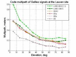
Multipath compatibility investigations similarly generated extended debate. The American delegation argued that the proposed BOC(15,2.5) modulation, with its chip rate of 2.5×1.023=2.5575 Mcps and sub-carrier frequency of 15×1.023=15.345 MHz, would introduce new multipath-induced biases into combined GPS-Galileo receivers due to cross-correlation sidelobes at specific code phase offsets. Multiple simulation campaigns were conducted by both sides, using different channel models and receiver architectures, before a shared understanding of the multipath interference mechanism was reached. These investigations consumed approximately 12 to 18 months of the total negotiating timeline. Progress was ultimately achieved through a combination of European concession on the BOC(15,2.5) component, which was removed from the open service signal plan entirely.

The First GPS-Galileo Agreement (2004)
The Agreement on the Promotion, Provision and Use of Galileo and GPS Satellite-Based Navigation Systems and their Applications was signed on June 26, 2004, at the EU-US Summit in Shannon, Ireland, by United States Secretary of State Colin Powell and EU External Relations Commissioner Chris Patten. It was the first formal international agreement between any two GNSS operators and established both the principles and the institutional machinery that would govern all subsequent cooperation.
The 2004 Agreement established the compatibility and interoperability definitions described as binding principles for both parties. It committed both the United States and the European Union to ensuring GPS and Galileo open service signals at the E1/L1 frequency of 1,575.42 MHz would share a common power spectral density, thereby enabling interoperable receiver designs. It also created a bilateral Working Group on GPS and Galileo Compatibility and Interoperability, mandated to meet regularly, resolve emerging technical issues, and oversee the implementation of agreed signal specifications.
From a technical standpoint, the 2004 Agreement codified the key outcomes of the preceding two years of negotiation: the removal of the BOC(15,2.5) component from the Galileo E1 Open Service, the adoption of BOC(1,1) as the interim common signal baseline, and the establishment of the new compatibility methodology as the agreed analytical framework for assessing any future signal changes. The agreement also addressed Galileo’s Public Regulated Service (PRS) and Safety-of-Life (SoL) signals, establishing principles for their coordination with corresponding GPS military and safety signals.
However, we, the European side, were not entirely satisfied with BOC(1,1) as the final outcome. The Agreement, therefore, explicitly opened the door to further refinement: the Parties shall work together without delay toward achieving optimization of that modulation for their respective systems. This clause reflected the European understanding that BOC(1,1), while sufficient to guarantee coexistence, did not yet exploit the full ranging and multipath performance that could be obtained from the available L1 spectrum. Extensive research started on the European side to find a superior modulation.
The Munich Meeting (2005) and the MBOC Agreement (2006)
Let me explain how my team and I, together with CNES, arrived at the new optimized signal. We knew a combination of two BOC spectra would yield better accuracy than BOC(1,1) alone. We, therefore, wrote a complex program that combined two, three and four BOC spectra with varying parameters, taking into account the relevant quality criteria for the new signal—multipath performance, ranging accuracy, and so on—as well as the European security constraints.
After running for more than a day, the computer produced a clear result: MBOC(6,1,1/11), a signal whose power spectral density (PSD) is a weighted mixture of the BOC(1,1) and BOC(6,1) spectra in a 10:1 power ratio, centered at 1,575.42 MHz within a transmission bandwidth of approximately 24.552 MHz (i.e. 24×1.023 MHz).
The question then became: How could we convince the U.S. to adopt our new optimized signal? With the permission of the EC, I proposed to our American counterparts a “non-meeting” (without EC colleagues): a decisive informal technical exchange to be hosted at my Institute of Geodesy and Navigation at the Bundeswehr University, a natural venue for such a discussion. The gathering, held in 2005, was deliberately structured as a workshop rather than a formal diplomatic session. No official minutes were kept, and the proceedings were not entered into the Working Group’s documentary record. This informality was intentional: It created an environment in which leading signal design experts from both sides—including members of the Signal Task Force and U.S. GPS program engineers—could engage in the kind of unconstrained technical dialogue that formal settings preclude. Although the meeting had been scheduled for a full week, we convinced our U.S. colleagues after the first day, and they agreed to adopt our new signal.
The final touch to the Galileo signal plan came in 2006, when the Working Group on GPS and Galileo Compatibility and Interoperability formally agreed upon the Multiplexed Binary Offset Carrier (MBOC) modulation as the common power spectral density for the E1/L1 Open Service signals of both systems.
The key insight that made this second agreement possible was the flexibility of allowing each party to implement the MBOC PSD through different time-domain waveforms—the decoupling of the spectral specification from its time-domain implementation. Both parties could thus claim their preferred implementation while committing to a common PSD that guaranteed interoperability.
The significance of the 2006 agreement can only be understood against the context of what MBOC replaced. BOC(1,1), the 2004 baseline, achieves a root-mean-square tracking error of approximately 0.1 m at C/N₀ = 45 dB-Hz with a 1 MHz discriminator early-minus-late spacing. MBOC(6,1,1/11) reduces this to about 0.06 m under the same conditions: a 40% improvement, while the multipath error envelope is reduced by 30% to 40% in the 0-300 ns reflector delay range most relevant to urban navigation. These performance gains, achieved at the cost of modest additional receiver complexity, justified the four years of analytical and diplomatic effort required to reach agreement.
Patent Filing and Controversy
The MBOC agreement was barely consolidated before it became the subject of a significant and contentious intellectual property dispute. Two British engineers who had participated in the GPS-Galileo Signal Task Force filed a series of patents covering the MBOC modulation concept. The assignee named in the patents was the UK Secretary of State for Defence. The patents were subsequently commercialized by a British company that began approaching receiver manufacturers and satellite system operators—including companies in both the United States and Europe—requesting royalty payments for use of the GPS L1C and Galileo E1 OS signals.
The controversy raised immediate questions about the circumstances of the patent filing. The inventors were serving members of the signal task force at the time the MBOC concept was developed collaboratively by the joint EU-US working group. The U.S. Department of State and the European Commission were both made aware of the dispute. The primary U.S. application encountered a non-final rejection notice at the United States Patent and Trademark Office, leaving its status uncertain for an extended period.
The dispute had practical consequences beyond the legal proceedings. Receiver manufacturers, facing potential royalty demands, were reluctant to commit to MBOC-based product designs until the intellectual property situation was resolved. This uncertainty threatened to undermine the commercial benefits the entire GPS-Galileo interoperability exercise had been designed to deliver. Several industry voices warned that an adverse outcome could force a reversion to a pure BOC(1,1) signal structure—losing the hard-won performance gains of MBOC entirely. Luckily, the dispute was solved some years later by the EC and the UK government. The use of MBOC was no longer in danger.
CBOC, TMBOC, QMBOC: Three Implementations of One Spectrum
A crucial feature of the MBOC agreement—and one that emerged directly from the informal Munich discussions—was its definition in the frequency domain rather than the time domain. MBOC(6,1,1/11) specifies that the power spectral density of the combined pilot and data channels must equal a weighted mixture of BOC(1,1) and BOC(6,1) PSDs in the ratio 10:1 but leaves each party free to choose how to produce that PSD through its time-domain signal waveform. This flexibility led to distinct implementations, one adopted by each party (EU, U.S., China).
Composite Binary Offset Carrier (CBOC) is the implementation selected by the European Union for the Galileo E1 Open Service signal. In CBOC, the ranging code is modulated by a weighted combination of a BOC(1,1) sub-carrier and a BOC(6,1) sub-carrier on each channel, with the two components added in anti-phase between the data and pilot channels. The CBOC was then patented by my team and CNES and later transferred to the EC.
Time-Multiplexed Binary Offset Carrier (TMBOC) is the implementation adopted by the United States for the modernized GPS L1 open signal they call L1C. Rather than blending the two sub-carriers on each chip, TMBOC assigns individual chips alternately to BOC(1,1) and BOC(6,1) modulation in a specific time-multiplexed pattern. The GPS L1C pilot channel uses TMBOC(6,1,4/33), in which four chips out of every 33 are modulated with BOC(6,1), and the remaining 29 chips use BOC(1,1).
Chinese researchers at Tsinghua University responded by developing a variant modulation specifically designed to achieve MBOC-equivalent performance while constituting an independent intellectual property right. Their solution, published in 2010 in Electronics Letters, was Quadrature Multiplexed BOC (QMBOC). The QMBOC approach modulates the BOC(1,1) and BOC(6,1) sub-carrier components on two quadrature phases of the carrier signal—using the in-phase (I) and quadrature-phase (Q) channels—rather than combining them on a single phase as in CBOC or interleaving them in time as in TMBOC. The QMBOC design was explicitly motivated by the need to avoid the MBOC patent claims: Chinese technical documentation from the BeiDou signal design process describes QMBOC as providing the “same receiving performance as TMBOC and CBOC, while avoiding MBOC patent risk.”
Setting the Standard
The GPS-Galileo frequency consultations left a lasting imprint on the global GNSS landscape. The compatibility and interoperability framework, the analytical methodology covering spectral separation coefficients, C/N₀ degradation thresholds, phase error analysis, and multipath envelopes, have been adopted as the standard approach for GNSS signal coordination internationally. The International Committee on GNSS (ICG), established under UN auspices in 2005 partly in response to the proliferation of GNSS systems, uses this methodology as the basis for its inter-system compatibility assessments. MBOC and its implementations—Galileo’s CBOC and GPS’s TMBOC, as well as BeiDou’s QMBOC—are now the reference modulations for the world’s two leading GNSS constellations and China’s system, collectively serving over five billion users.
The patent controversy, while damaging to the collaborative spirit of the GPS-Galileo process, ultimately did not prevent the widespread adoption of MBOC-based signals, and the combined GPS L1C, Galileo E1 OS, and BeiDou B1C infrastructure has delivered the positioning performance improvements that the original negotiators envisaged. I am glad and honored that I could attend and shape the Galileo signals and related meetings with my team on behalf of Germany.
The GIOVE-A and GIOVE-B satellites, modest in mass and modest in mission scope, saved the entire program from regulatory extinction. The four years of negotiations, with their thousands of pages of technical analyses, their contested phase error calculations, their multipath simulation campaigns, and their informal workshop in Munich, produced a signal design framework that has proved more durable than any of us could have foreseen. The second agreement—reached without minutes, in my academic institute in Bavaria—may be the most consequential undocumented meeting in the history of satellite navigation.