About four years ago, Kanwar Singh, a U.S. Army Officer, began working with the Army Research Lab to advance and commercialize a new technology designed to both complement and augment GPS in degraded or denied environments.
The technology, with about 10 years of research and investment behind it now, leverages computer vision algorithms and reference datasets to navigate and position effectively—without relying on GPS, cellular or Wi-Fi.
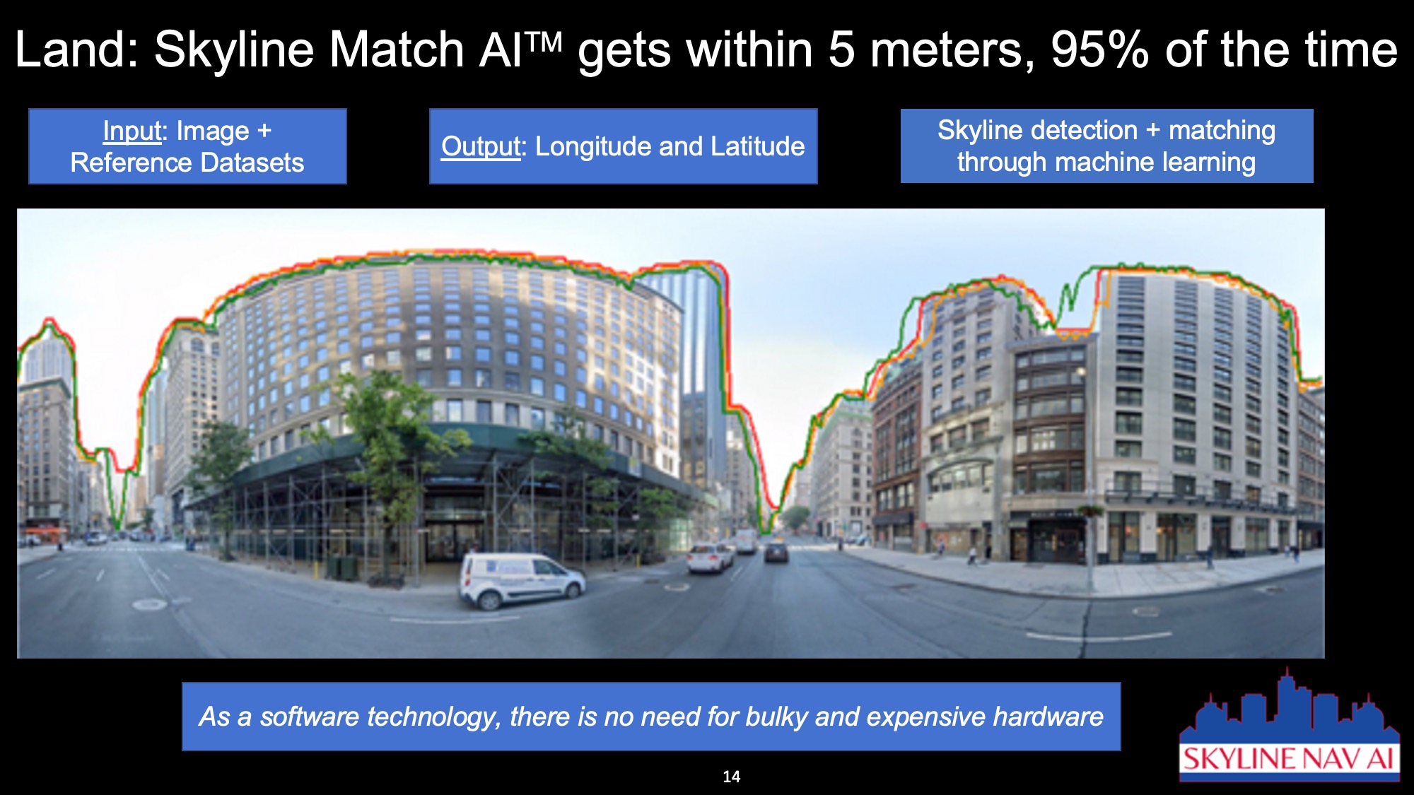
Skyline Match AI can find initial positions by scanning the terrain and identifying discernible skylines, and has uses in both military and civilian applications where relying on GPS alone may be an issue.
The technology can get users within 5 meters in urban areas with unobstructed view 95% of the time. It also can be combined with inertial, GNSS and SLAM for more precise results.
“It’s very easy for adversaries to jam, deny and disrupt GPS,” said Singh, CEO of Skyline Nav AI, the startup company behind Skyline Match AI. “This technology is simple but game changing. By taking a picture of what’s around you, you can get your location back.”
Finding the Right Partners
Over the years, Skyline Nav AI has developed strategic partnerships and collaborations with various entities, including the US Air Force, NASA, US Army, Draper Labs, MIT, Army Research Lab, Air Force Research Lab, NGA and FedTech. The company also recently announced partnerships with BAE Systems and Kearfott Corporation.
BAE Systems, Singh said, has integrated Skyline Match AI into night vision cameras. The high-definition, extended view sensors are built with BAE Systems’ longwave infrared camera cores to deliver low-latency images in any condition. The four cameras provide a 360 view for enhanced situational awareness and are compatible with existing vehicle systems.
“With our capability, the cameras can geo locate themselves,” Singh said. “Imagine there’s a truck operating at night, but if it loses GPS, what do you do? That’s where our capability comes in. As the vehicle drives and the cameras are being used for nighttime operations, our capability in conjunction with the BAE system can now navigate based on what they’re seeing around them.”
Skyline Nav AI also recently announced a partnership with Kearfott, a navigation, motion and control systems manufacturer. Through the collaboration, the companies will develop position and navigation systems that integrate Kearfott’s inertial sensors with Skyline Nav AI’s computer vision technology. The combined solution can be used across multiple areas, including military, aerospace and commercial markets.
“Kearfott’s legacy of excellence in inertial navigation, paired with Skyline Nav AI’s cutting-edge visual navigation technology, sets the stage for the development of transformational innovations that will enhance the capabilities of position and navigation systems,” said Kearfott President John Stanfill, according to a press release about the partnership. “This collaboration underscores our commitment to innovation and meeting the evolving demands of our customers.”
Inertial sensors tend to drift over time, Singh said, and Skyline Match AI corrects that.
“If you lose GPS in a flight operation, the inertial sensor can be off hundreds of meters,” he said. “Our capability can see the terrain and then start correcting.”
The Applications
The goal is to provide an alternative to GPS in areas it can’t reach and to augment GPS when it’s failing. Already, the technology has been used for mobile location, drones, land vehicles and fleet navigation, Singh said.
“There are a lot of applications on both the military and the commercial side,” he said. “Our capability can be in the hands of warfighters on a cell phone or on drone munitions or in aircraft, even if adversaries are jamming and disrupting GPS.”
On the commercial side, they’re “laser focused” on the urban canyon challenge, Singh said, and leveraging the technology for more effective navigation.
The next step is to expand to autonomous vehicles and AR headsets, likely next year. And as the 2023 NASA Entrepreneurs Challenge winners, which focused on lunar exploration and climate science, the startup has its sights set on space rovers by 2026.
“We can compare data from lunar reconnaissance to give you position and navigation and help with precision landings,” Singh said. “We’re excited about taking the capability to the moon in the next few years, but it’s a complicated challenge. We are in discussions with different organizations. My goal is to figure out how we can use our capability to help the U.S. win the space race in the 21st century.”
A Trio of Solutions
Skyline Match AI is set up similar to the Shazam music app, Singh said, which can identify music based on a short sample. Skyline Match AI helps users figure out where they are by taking a picture.
“Companies like BAE have their own PNT platforms,” he said, “but now they can use our capability on their camera and fuse that data with GPS and inertial.”
The company offers three options: the Skyline Nav AI iOS for commercial use, the Android Tactical Assault Kit for U.S. military use, and the API + SDK for edge autonomy.
The Tactical Assault Kit combines the iOS app and the API plug, allowing users to take pictures on their phone and to get a location back with no requirement for connectivity. Singh has been working with Erik Blasch, program manager, Air Force Office of Scientific Research, Simon Khan, research scientist, Air Force Research Lab, and Ralph Kohler, principal engineer, Air Force Research Lab, to develop Skyline Match AI solutions.
The Air Force Research Lab opted to help fund this project because of its value in the military domain, Blasch said. It offers a different approach from dead reckoning and other strategies that already exist to back up GPS.
“Being able to incorporate something from your cell phone is important,” Blasch said, “and the visual imagery will help with landmarks to enhance the navigation. So it’s a synchronized approach.”
Beyond military uses, he also can see this technology being leveraged in disaster response where localization is needed for someone who was separated from the group, for example, making it possible for users to quickly refine their position.
Backing up GPS
Blasch expects the technology to be used in conjunction with other solutions to enhance navigation even further. There are many opportunities to fuse this technology with others, providing an even more reliable back up to GPS.
“Our primary navigation has four main challenges: accuracy, availability, continuity and integrity,” Singh said. “Our mission is to provide an alternative to GPS in areas it can’t reach and to augment GPS where it’s faulty.”


