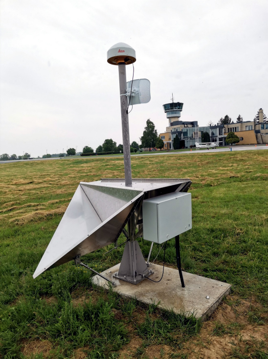
Researchers in Hungary have developed a new method for geodetic height determination, exploiting the synergies of multi-constellation GNSS and interferometric synthetic aperture radar (InSAR). The solution, proposed by the Lechner Knowledge Center in Budapest, comprises a modernized reference network of integrated, continuously operating reference stations (CORS) with InSAR corner reflectors.
The GNSS-based CORS network provides accurate and reliable positioning data for surveyors and map-makers, and other users in the construction and transportation sectors. In this new application, CORS technology is augmented by InSAR, an emerging earth observation-based technique for mapping the displacement of geo-objects, i.e., the Earth’s surface itself or objects on it.
InSAR is effective all day and all night and in all weather conditions, but it can be negatively impacted by factors including surface conditions, such as vegetation cover. Some of InSAR’s limitations can be mitigated by the use of corner reflectors, which can aid in the acquisition of displacement measurements in areas with dense vegetation or snow cover. Corner reflectors reflect radar signals back to the emitting satellite, requiring no power source or post-installation maintenance.
Potential breakthrough
Height is a key measure needed to establish the true position of a point on, above or below the earth’s surface, important in the surveying and construction industries and especially when directing the flow of water. At the recent presentation hosted by the European Space Agency (ESA), Kenyeres Ambrus of the Lechner Knowledge Center said the new approach represents a quantum leap in geodesy, enabling the generation of a more precise and accurate, digital, semi-kinematic height reference, taking into account ground motion in height determination.
A pilot network of seven stations, along with a new, digital database were successfully tested in field campaigns in Szeged, Hungary’s third largest city. This included the recording of static measurements as well as an RTK campaign. The results showed a clear superiority of the combined multi-GNSS CORS and InSARapproach compared to conventional height determination methods.
The reference stations now form part of a new RTK service network, potentially the starting point for the next generation of primary height benchmarks. Ambrus said a three-year program of extending the InSAR-enhanced network nationally is now underway in Hungary, eventually to encompass a large number of existing CORS stations in that country.
The development of the new system was carried out under the ESA-funded INGRIM project (‘Integrated Galileo Reference Infrastructure and technology development for height modernization’), part of ESA’s NAVISP Element 3, which supports participants’ national PNT strategies, including the development of new products, applications and services.


