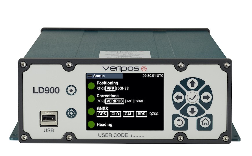
A new marine-certified quad-band GNSS receiver, the LD900 from VERIPOS, delivers accurate and reliable positioning in demanding offshore environments. The LD900 can track four GNSS frequencies simultaneously to ensure a precise position is always available at sea. When combined with Apex5 correction services from VERIPOS, it delivers accuracy levels as precise as 5 cm (95%) to provide robust positioning for the most challenging applications, including deepwater drilling, seismic, construction, and survey.
Capable of multi-constellation and multi-frequency (MCMF) GNSS tracking, the LD900 tracks GPS, GLONASS, BeiDou, Galileo and QZSS constellations, and supports all VERIPOS correction services, which use Precise Point Positioning (PPP) to deliver centimeter-level accuracy across the globe.

The receiver supports multi-channel L-Band tracking that provides simultaneous reception of services from three satellites broadcasting VERIPOS Apex5 corrections, which reduces the risk of satellite masking or blocking to ensure continuous operations and avoid vessel downtime. Using the independent L-Band RF input on the LD900 allows the connection of a dedicated L-Band antenna ensuring optimal reception of correction services, especially at high latitudes. This availability and accuracy are well-suited for oil and gas exploration activities.
Real-Time Kinematic (RTK) corrections can be utilized by the LD900 for applications where this service is required.
The receiver’s intuitive color display and navigation menu make setup, configuration and system status monitoring simple. The display also helps troubleshoot issues with the LD900 allowing faults to be quickly diagnosed and resolved. The LD900 can also be configured remotely through the VERIPOS Quantum software.
The receiver also offers advanced signal filtering to mitigate the effects of interference from other transmitters, and automatic 72 hour rolling data log for incident support.
Receiver physical characteristics:
Size: 300 x 200 x 80 mm
Weight: 3.8 kg
Operating Temp: -15°C to +55°C
Input Voltage: +12 to +24 VDC
Power Consumption: 13 W (typical)
Marine certification allows the LD900 to be interfaced into Dynamic Positioning systems, assuring accurate and reliable positioning for critical marine operations.
“The LD900 builds upon decades of experience in satellite positioning as a technology leader in the offshore GNSS market by providing accurate, reliable and robust satellite positioning for a variety of demanding marine uses,” noted Dr. David Russell, Marine Segment Portfolio Manager, Hexagon’s Autonomy & Positioning division.
555 channels. Signal Tracking:
GPS: L1 C/A, L1C, L2C, L2P, L5
GLONASS: L1 C/A, L2 C/A, L2P, L3, L5
BeiDou: B1I, B1C, B2I, B2a, B3I
Galileo: E1, E5 AltBOC, E5a, E5b, E6
NavIC (IRNSS): L5
SBAS: L1, L5
QZSS: L1 C/A, L1C, L2C, L5, L6
Horizontal Position Accuracy (RMS)
Single Point L1: 1.5 m
Single Point L1/L2: 1.2 m
SBAS: 1 m
VERIPOS DGNSS: 1 m
VERIPOS PPP: 5 cm
RTK: 1 cm + 1 ppm
Initialization time < 10 s
Initialization reliability > 99.9%
Maximum Data Rate
Measurements up to 20 Hz
Position up to 20 Hz.


