
 Sea State Monitoring
Surrey Satellite Technology Limited (SSTL) will lead a British project to exploit signals from GPS and other GNSS satellites that are reflected from the Earth for remote sensing purposes.
The project will investigate a prototype instrument capable of measuring the roughness of the sea and soil moisture content, providing data for atmospheric science and for operational ocean and weather forecasting.
SSTL will lead one of five teams awarded funding by the Centre for Earth Observation Instrumentation (CEOI), the Natural Environment Research Council (NERC) and Department for Innovation, Universities & Skills (DIUS) supported initiative to further technological capability in line with UK Earth observation science priorities. The SSTL-led team will include experts from the University of Surrey, the University of Bath, and the National Oceanographic Centre in Southampton.
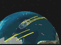
The instrumnent, which will fly onboard a separate small satellite, will analyze GNSS signals reflected from land, ice and ocean. According to SSTL, a flexible multi-channel receiver will be developed to detect the reflected GNSS signals for surface sea-state measurements.
Sea-surface roughness is important for operational ocean and weather forecasting and affects many areas of ocean and atmospheric science. For example, the air-sea exchange of gases is controlled by surface roughness.
Research results to date suggests that the better sampling offered by a new instrument will have a direct effect on understanding the magnitude and distribution of atmospheric carbon dioxide uptake by the ocean, with important applications in the prediction of high winds, dangerous sea states, risk of flooding, and storm surges.
Opportunities to fly this instrument have been identified both through SSTL’s own satellite launching capability and through the European Space Agency (ESA) as an approved addition to a future Soil Moisture and Ocean Salinity operational mission (SMOS-ops) to measure soil moisture and ocean salinity.


")
