China’s development of the BeiDou system continues with the release of updated technical information and plans for more launches as well as what appears to be a practical demonstration of the constellation’s global messaging capability.
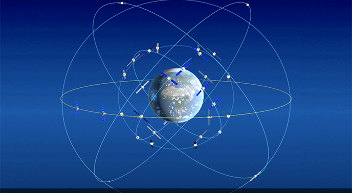
The China Satellite Navigation Office has released version 3.0 of its Interface Control Document for Open Service Signal B1Ior ICD. Both BeiDou’s BDS-2 and BDS-3 satellites transmit the B1I signal, which supports China’s publically available service. B1l-capable spacecraft include satellites at Medium Earth Orbit (MEO), Inclined GeoSynchronous Orbit (IGSO) and Geostationary Earth Orbit (GEO).
The ICD gives the signal structure, frequencies and some 85 pages of other signal characteristics, as well as details like the structure of the navigation message.
On December 27 China completed the preliminary BDS-3 system — the second phase of a three-phase development process — enabling worldwide coverage. Version 2.0 of the performance standards for the open service was released at a press conference announcing completion of the initial global system. The standards indicated a positioning accuracy of 10 meters horizontal and 10 meters vertical (95 percent confidence level). Velocity accuracy was 0.2 meters per second (95 percent confidence level), timing accuracy was 20 nanoseconds (95 percent confidence level) and system service availability better than 95 percent. In the Asia-Pacific region the positioning accuracies were 5 meters horizontally and 5 meters vertically (95 percent confidence level), said Ran Chengqi, director general of China Satellite Navigation Office, speaking to the press.
Launches
The final development phase of the BDS-3 constellation is expected to be complete sometime next year. At that point the constellation will have three GEO satellites, three IGSO satellites, and 24 MEO satellites plus spares. Seven launches carrying 10 satellites are planned this year, according to a Xinhua news report citingthe China Aerospace Science and Technology Corporation. A total of 12 satellites will be launched to complete the system Rantold the audience.
“By 2035, with BDS as the core, a more comprehensive, more integrated and intelligent national integrated positioning, navigation and time (PNT) system will be completed,” Ran said.
Messaging
China has also reportedly demonstrated BeiDou’s messaging capabilities. A Xinhua story posted in early February said researchers from the Chinese Academy of Sciences (CAS) were using BeiDou to send data back from 20 sets of submersible buoys in China’s scientific observation network in the West Pacific.
Scientists fitted the buoys with BeiDou satellite communication modules when they serviced them during a 74-day expedition reportedly running from roughly November 2018 through January 2019.
Until this upgrade the scientists were relying on foreign remote sensing satellites for real-time retrieval of marine data. Now there is improved data transmission security and reliability, according to Wang Fan, director of CAS’s Institute of Oceanology.
“The data collected by the submersible buoys, including the temperature, salinity, flowing speed and direction of seawater, should be transmitted back to the ground lab by satellites. The amount of data was huge,” said Wang Jianing, a researcher at the institute, according to Xinhua.
 Signal Plans")


