April 9, 2020

NATO Software Estimates Areas of Degraded GNSS Service

Experts at the NATO Communications and Information (NCI) Agency have developed a software-based tool that can estimate the area where an interfering signal would degrade or deny GNSS signals, and assess the scale of the interfering signal and its potential impact on operations. Principally of interest are jamming or spoofing attacks on GPS or Galileo, of course.

The Radar Electromagnetic and Communication Coverage Tool (REACT), was sponsored by the NATO Navigation and Identification Programme of Work. It serves as a proof-of-concept of how analytical tools could support the execution of operations. The tool is also available to NATO Nations free of charge. For now, the software is only used for trial and experimentation.

NATO REACT, photo courtesy NCI

To use the software, operators input information on the particular jammers – their locations and technical characteristics — and the software produces a map of the area where the interfering signals would degrade or deny GNSS receivers. This can be displayed on the NATO Core Geographical Information System (GIS) map.

The next phase of the project focuses on ensuring the software can work on NATO classified networks, which would make it more available to operational commands to test and ensure such support measures are properly integrated into NATO operations.

The software and its estimations were demonstrated to operators during exercise Trident Jupiter 2019, part 1, to collect their feedback. The exercise gathered 3,000 military and civilian personnel as participants, evaluators and observers. Thirty NATO member and partner nations participated in nine different exercise locations across Europe.

“Ten consecutive twelve-hour working days and a relentless, ever-increasing, battle-rhythm tempo came to an end as Exercise Trident Jupiter 2019-1 (TRJU19-1) reached completion on Thursday, Nov. 14, 2019,” the agency stated.

TRJU19 was the largest and most complex exercise planned and executed by the Alliance’s Joint Warfare Centre to date. TRJU19-2 took place in March 2020.

“NATO’s adversaries have the ability to degrade or deny GPS-enabled capabilities,” said Jean-Philippe Saulay, a NATO Navigation and Identification Officer. “NATO must take appropriate measures to ensure Allied forces can operate in a degraded or denied environment.”

“NATO must maintain superiority in the electromagnetic environment, including but not limited to, positioning, navigation and timing services,” said Dr Enrico Casini, Communications and Navigation Engineer at the NCI Agency. “Situational awareness of navigation systems in a contested electromagnetic environment contributes to that superiority. NATO is enhancing its knowledge of electronic warfare technology,” Dr Casini said. “The electromagnetic environment has become even more contested in recent years. One aspect of that is interference with GNSS systems.”

Photos courtesy NATO Communications and Information Agency.

By Inside GNSS
March 31, 2020

GPS Ground, Space, User Segments and Cyber Security Move Forward Together

GPS got a twofer on March 27 with major advances for the ground segment and the space segment. The Contingency Operations (COps) program, an upgrade necessary to the Operational Control System for it to command and control the new GPS III satellites, was approved. And the second GPS III satellite to orbit was approved, a stage that should shortly be followed by it  becoming available to military and civilian users.

Both steps occurred upon receiving the U.S. Space Force’s Operational Acceptance approval.

COps has operated on a trial basis since last October, supporting the developmental testing of the GPS III ground and space capabilities. The trial period culminated in a fully mission capable rating from the Air Force Operational Test and Evaluation Center’s Operational Utility Evaluation.

GPS SV02 launched on Aug. 22, 2019, and upon completing its test, COps took control of it, bringing it into the III fold along with its earlier sibling, GPS III SV01. Administering COps and in direct control of both satellites is the 2nd Space Operations Squadron at Schreiver Air Force Base, Colorado.

“Of all the programs that will be delivered this year, there are few that carry with it as significant an impact to the warfighter and civilian users as [COps] will. This is truly a remarkable leap forward for the GPS enterprise and the capability it provides, and I couldn’t be more proud of the team that came together to make it happen,” said Lt. Col. Stephen Toth, 2nd Space Operations Squadron commander.

Lockheed Martin built both satellites as well as the COps command and control program. The company is under contract to build up to 32 of the new generation and its follow-on version, carrying new technology and advanced capabilities in payloads made by L3Harris. The military advances aboard these satellites include the new military M-code, and COps is necessary to administer this signal.

19 previously orbited IIR-M and IIF generation GPS satellites can broadcast M-Code, as can GPS III SV01 and SV02. The third M-code enabled GPS III satellite should launch in April of this year. The military is getting very close to full M-code capability, which will occur when 24 orbiting satellites have it. Its operational availability is on track for 2020.

User Equipment Not Far Behind

The M-Code Early Use (MCEU) upgrade, delivered earlier this year, is a key part of COps, enabling the system to task, upload and monitor M-Code within the GPS constellation. It also supports testing and fielding of modernized user equipment, prior to the completion of the next-generation ground control system, or OCX.

The M-Code encrypted GPS signal enhances anti-jamming and protection from spoofing, and increases secure access for U.S. and allied military forces.

A key to enabling M-Code is a new software-defined receiver Lockheed Martin developed and is installing at all six Space Force monitoring sites. The M-Code Monitor Station Technology Capability receives and monitors M-Code signals.

Red Dragon Breathes Cyber Security

Finally, Lockheed Martin als0 delivered the Red Dragon Cybersecurity Suite (RDCSS) Phase III upgrade during the fourth quarter of 2019, dramatically improving Defensive Cyber Operations (DCO) visibility into GPS network traffic. Other add-ons include user behavior analytics to analyze patterns of traffic and network taps to improve data collections.

“GPS is an attractive target for our adversaries, so it was critical we bring our best cybersecurity defenses to the table,” said Stacy Kubicek, Vice President of Mission Solutions Defense and Security.

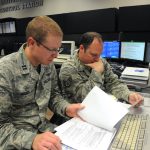
[Image above: Capt. Adam Moody, 2nd Space Operations Squadron Global Positioning System Operations Support flight commander, and Staff Sgt. Carl Ellinger, 2 SOPS GPS mission chief, review a checklist of procedures for a transfer operation at Schriever Air Force Base, Colorado (U.S. Air Force photo/Dennis Rogers)]

By Inside GNSS
August 27, 2019

Australian Government Purchases GNSS Jamming & Spoofing Detection

Australia’s Department of Defence has awarded AUS$28 million (about $19 million U.S.) to a range of technology companies for cutting-edge concept exploration and technology demonstration. Four of the 15 awarded projects involve satellite technology, and one of them, given to GPSAT Systems Australia Pty Ltd, is to develop GPS jamming and spoofing countermeasures.

Read More >

By Inside GNSS
November 30, 2017

Army Launches 5-Year PNT Technology R&D Program

The Army is kicking off a wide-ranging, five-year research effort to develop new position, navigation and timing (PNT) technologies for battlefield use.

The goal is to overcome technical barriers in a wide range of areas and military officials are offering to fund multiple, and even multi-phase, cost-plus-fixed-fee (CPFF) efforts to do that. The work may range from studies and analysis to development work that results in the production of a prototype-style deliverable or breadboard and/or a demonstration.

Read More >

By Dee Ann Divis
IGM_e-news_subscribe