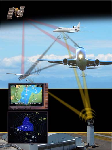
The seeming efficiency of having unmanned aircraft carry the same GNSS-based collision avoidance transmitters required for manned aircraft has generated a lot of interest as a possibly safe way to easily integrate unmanned aerial vehicles (UAVs) into the nation’s air traffic control system.
The seeming efficiency of having unmanned aircraft carry the same GNSS-based collision avoidance transmitters required for manned aircraft has generated a lot of interest as a possibly safe way to easily integrate unmanned aerial vehicles (UAVs) into the nation’s air traffic control system.
The Federal Aviation Administration (FAA)–mandated automatic dependent surveillance-broadcast (ADS-B) system requires manned aircraft to carry devices that transmit their GPS-derived positions to both air-traffic control officials and other properly equipped planes. The system is being implemented now, and airplanes flying in the U.S. National Air Space will largely be required to carry the transmitters by 2020. Europe is mandating new aircraft be equipped by 2017 and retrofitted planes by 2020.
As yet, no overall requirements have been set for unmanned aircraft systems (UAS) to carry ADS-B transmitters in the United States, although NASA has been incorporating ADS-B into its research on a UAS traffic management (UTM) concept. The space agency even supplied ADS-B data to drone operators during a November 2015 demonstration.
Amazon, which wants to use drones to deliver packages, announced last spring it would put its enormous resources behind an effort to drive down the cost of ADS-B transmitters and make them more practical for use by small unmanned aircraft systems (UAS).
Last month, NASA’s Armstrong Flight Research Center licensed to Vigilant Aerospace Systems a new sense-and-avoid system that incorporates ADS-B avionics to improve safety for aircraft, particularly UAVs.
But it’s not that straightforward. The ADS-B infrastructure was not designed to handle hundreds of thousands of flights (some 700,000 UAS were sold last year alone). Moreover, ADS-B does not provide nationwide coverage for altitudes below 500 feet. In fact, a glance at an ADS-B coverage map shows that large stretches of the United States — particularly rural areas where some of the most promising agricultural UAV applications are focused — do not have such coverage.
Unmanned aircraft are currently required to fly below 400 feet and a proposed operating rule for small drones, which the FAA expects to finalize soon, would raise that to 500 feet going forward.
Extending ADS-B Coverage
The Harris Corporation, the FAA’s prime contractor for ADS-B now that it has absorbed Exelis, is proposing a low-altitude fix.
In early May the company announced ADS-B Xtend, a dual-band receiver and relay system that can be installed in areas without close-to-the-ground ADS-B capabilities. It will provide UAV operators with aircraft tracking data, maps, and weather information.
Harris is also partnering with PrecisionHawk, a Raleigh, North Carolina manufacturer of UAVs and provider of aerial data and safety services for the commercial drone industry, to include information from the Low Altitude Tracking and Avoidance System or LATAS. LATAS uses cellular networks to gather and disseminate location data broadcast by devices on drones.
"Each platform has the intelligence to transmit its location and altitude in real time, which is sent to air traffic controllers and pilots in aircraft cockpits while reporting back to the FAA," PrecisionHawk said in a statement. With the partnership LATAS customers also will be receiving Xtend data.
"So we’re going to be bringing in LTE [cell phone system] data," said Christian Ramsey, the UAS campaign program manager for critical networks at Harris Corporation. "(And) through their LATAS product . . . they’re going to have customers that are receiving this full data set or are receiving data that’s important to them."
The Xtend ground receivers will have a range of some 150 miles and cost in the single or low tens of thousands of dollars, said Ramsey. They can be attached to existing structures or to mobile vehicles for roaming coverage.
The devices are not currently intended to fill in nationwide coverage, said Ramsey, but to provide service in specific areas.
"We’re approaching it on a customer by customer basis. Who needs that coverage—whether it’s BNSF Railroad or an airport or a power line company—we would install these along their specific route," he added.
The BNSF Railway Company is one of a half dozen firms engaged in Pathfinder projects with the Federal Aviation Administration (FAA) to work out key technologies for future unmanned applications. BNSF is researching operations beyond the immediate line of sight of UAV operators, a capability considered essential to economically inspecting railroad lines and other infrastructure SUCH AS pipelines. Beyond-line-of-sight applications are just the sort of use cases Xtend is designed for.
"It’s not a universal solution," Ramsey told Inside GNSS. ADS-B likely would not be needed for the low-risk flights many drones will be engaged in, he said, flights that take place during the day within eyeshot of the operator. "But if you’re flying beyond line of sight or flying at night or flying in a congested airspace that’s controlled, then maybe you do need ADS-B on there. It’s more of a risk-based approach to understanding when you do and when you don’t."
Radio Traffic Jam
Implementing Xtend based on risk could help ameliorate another ADS-B limitation— a shortage of bandwidth.
A study released by MITRE earlier this year showed that transmissions by large numbers of drones could swamp the system. MITRE looked at what might happen if small unmanned aerial systems (SUAS) were added to the air traffic control system using a standard baseline established by the FAA for analyzing ADS-B surveillance systems in the 2020 timeframe. The researchers found that, assuming a density of about 17 SUAS per square nautical mile or about 5 per square kilometer over an area 32 nautical miles in diameter, enough co-channel interference could occur that it "may negatively impact aircraft-to-aircraft ADS-B performance between civilian aircraft."
“[U]nconstrained use of current ADS-B for large fleets of closely clustered SUAS does not appear advisable,” the MITRE study concluded.
Focusing ADS-B only on drones undertaking higher-risk missions could help ease that potential for frequency interference. MITRE is now working on Phase 2 of the study to understand the level of interference risk posed by lower numbers of UAVs "to see where that sort of breaking point is," said Ramsey.
But what about other limitations, including the potential for interference to the GPS signal either from overall disruption to the GPS constellation or from more localized jammers purchased, ostensibly, to protect privacy.
"We handle GPS outages within our ADS-B (system) through a number of mechanisms," Ramsey told Inside GNSS. "If it’s a short outage, the radios themselves have internal clocks, high precision internal clocks, so that it can sort of coast through a blip."
eLoran Option
For longer-term outages Harris is exploring providing alternate position, navigation, and timing information through eLoran, said Ramsey.
"We think eLoran could possibly be an alternate backup for GPS," he said.
The firm now has an eLoran base station operating in Wildwood, New Jersey, that it is using for testing. In April it successfully demonstrated how eLoran could provide timing data accurate to within seven nanoseconds to the New York Stock Exchange.
Although eLoran does not have the same positional accuracy as GPS — 10 to 20 meters versus 7.8 meters or better with unassisted GPS — it may be accurate enough to handle emergencies.
"It has a lower precision certainly than GPS," Ramsey acknowledged, "but as a backup system it may be good enough to keep everything from falling out of the sky."
Imagine a future, he said, where there are thousands of drones in the air, all dependent upon GPS — and then they lose their GPS signal.
"What do they do? Do they go home? Do they just hover?" If they are supposed to return home they won’t know where to go, he said.
Such scenarios have Harris considering incorporating eLoran receivers into ADS-B as a way to mitigate the loss of GPS, though Ramsey stressed it is still very early in the research and development program.


