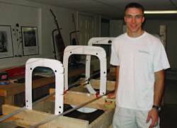
 Veth proudly poses with his RV-8A fuselage components securely fastened in a jig. The RV-8A is a two-place, tandem, experimental aircraft that is home-built from kit components. When completed, he plans to use the aircraft as an experimental navigation testbed.
SIDEBAR: Mike Veth’s Compass Points
Over the course of Lt. Col. Michael Veth’s 20-year career in the U.S. Air Force (USAF), certain navigation technologies may have changed dramatically, but working toward increased accuracy has remained a constant.
SIDEBAR: Mike Veth’s Compass Points
Over the course of Lt. Col. Michael Veth’s 20-year career in the U.S. Air Force (USAF), certain navigation technologies may have changed dramatically, but working toward increased accuracy has remained a constant.
Whether testing the navigation capabilities of military jets, serving as deputy director of the Predator UAV Program, mentoring aspiring electrical engineers at the Air Force Institute of Technology (AFIT), or building an experimental airplane, Michael Veth’s career has been anchored by a dedication to enhancing navigation technology and expanding its applications.
Veth now serves as deputy director of the 96th Range Group, serving as second in command of a 125,800-square-mile open test range at Eglin Air Force Base near Valparaiso, Florida.
His group is part of the 96th Test Wing that started out as a B-17 Flying Fortress bomber unit in England during World War II and played an important role in the Strategic Air Command’s deterrent force during the Cold War.
He leads a team of 1,400 civilians and contractors and maintains and operates test facilities including the Guided Weapons Evaluation Facility, the Joint Preflight Integration of Munitions and Electronic Systems (JPRIMES) anechoic chamber, and McKinley Climatic Laboratory, an all-weather testing center National Historic Mechanical Engineering Landmark.
Veth’s career had its beginning in family backpacking trips throughout the Ozark Mountains of Missouri and a childhood love of maps that he shares in common with his brother, Matt.
“I have always been interested in navigation and maps,” Veth says. “We were really active in Boy Scouts and learned how to properly read a map. My brother has this crazy ability to memorize geographic details. He is now a cartographer — probably a good career choice for him, and I do the navigation engineering and research!”
GNSS, Ashtech, and the B1-B
Veth began working with GNSS technology in 1995 after completing his master’s degree in electrical engineering at AFIT. As part of the 419th Flight Test Squadron at Edwards Air Force Base in southern California, Veth worked as the lead navigation system analyst for the Boeing B-1B “Lancer” radar offensive avionics system.
During his time at Edwards AFB, the B-1B navigation system was upgraded with a GPS receiver for the first time. The new integrated system was very well designed and highly accurate, Veth says, adding, “[It] was, in fact, much better than our navigation truth reference systems of the time.”
That development ultimately resulted in the GAINR (GPS-Aided Inertial Navigation Reference) system. Veth points out that, even after all these years, the GAINR system is still serving as the position, velocity, and altitude truth reference for the Air Force Flight Test Center.
Veth spent three years with the 419th Flight Test Squadron “This was an excellent experience for a young engineer, a great combination of hands-on work with the jet and good engineering analysis,” he says.
One technological innovation from this project that stands out for Veth was the use of the Ashtech Z-12 GPS receiver.
Boeing engineers developed a post-flight smoother algorithm that combined B-1B raw inertial data with Ashtech Z-12 carrier phase measurements as an additional risk-reduction measure. This was used as a reference system to verify GAINR performance. “That turned out to be a truly eye-opening experience. These were exciting times!” Veth says.
With that assignment completed, in 1998 Veth moved on to the USAF Test Pilot School, where he flew a wide range of different types of jets and evaluated their performance, controls, and avionics. The next stop: Joint Surveillance Target Attack Radar System (JSTARS) Test Force in Melbourne, Florida. There Veth served as a flight test engineer and led a 17-person team in evaluating the performance of the system designed by Northrop-Grumman Company (NGC).
Veth remembers his JSTARS tasking as an excellent post for an engineer. “The aircraft was essentially a flying computer room!” he says, and the NGC engineers that designed the system were outstanding radar and signal processing experts.
The second great aspect of this job was the leadership opportunities afforded to the Flight Test Engineers.
This experience reinforced Veth’s technical mastery and interest in experimentation — not to mention his leadership skills. Ordinarily, test pilots serve as mission commanders.
Because almost all of the testing at JSTARS was related to the radar, however, the flight test engineer led the team.
“It was during this job that I earned my private pilot’s license and instrument rating, which ultimately led to my long-term project of building an experimental airplane,” he says.
Veth is currently building a Van’s Aircraft RV-8A, which falls under the Federal Aviation Administration’s “Experimental – Amateur Built” category. “Right now, I’ve completed the empennage, wings, and I’m working to finish the fuselage next. I’ve learned a lot during the build process. It’s been fun!”
Stinger Meets the Predator
In October 2001, Veth was appointed deputy manager of the MQ-1A Predator Program. One of the earliest types of unmanned aerial vehicle (UAV), the Predator was built by General Atomics and used by the Air Force and Central Intelligence Agency (CIA).
Originally designed in the early 1990s for reconnaissance and forward observation, the Predator was subsequently modified to also carry two AGM-114 Hellfire missiles or other munitions. It has seen extensive use in such regions as Afghanistan, Pakistan, Iraq, and Yemen.
At the 645th Aeronautical Systems Group, better known as the Big Safari Systems Program Office at Wright-Patterson AFB in Ohio, Veth was responsible for administering the developmental test strategy for the UAV program and then making sure that the testing met safety and technical standards.
This assignment included a forward deployment to conduct a quick-reaction software upgrade test.
During this busy, dynamic time for the Predator program, Veth also led the first-ever UAV air-to-air missile test and evaluation, in which the Stinger missile was integrated with the Predator MQ-1 in order to give the UAV’s defensive capabilities, as Predators were often targets of airborne attack.
Turning Point
After administering the Predator program, Veth decided he wanted to get back into engineering. In 2003, he was accepted into the electrical engineering doctoral program at AFIT, also located at Wright-Patterson AFB.
“This was a huge turning point for me,” he says.
The focus of his doctoral studies involved experimental image-aided navigation — integrating inertial sensors and imaging to develop “a completely passive navigation system” — an interest in imaging that goes back to a 3D visualization tool he created during his work on the MSEE degree.
The experimental approach taken in his doctoral program gets back to a core appeal of navigation technology for Veth, which is its interdisciplinary nature. Researchers working on related technologies, such as those for communication and control, must work in tandem in order to produce useful applications.
The high caliber of the engineers at AFIT facilitated this kind of exploratory working model, Veth says.
The Institute breeds “a common vision and level of enjoyment that enables collaboration and productive competition that raises everyone to a higher level of aptitude and achievement,” he explains.
Veth completed his Ph.D. in 2006 and joined the faculty of electrical engineering as an assistant professor at AFIT where he mentored and guided students working towards advanced degrees. Then, from 2006–2010 he also served as deputy director of the Advanced Navigation Technology Center (ANT), an Air Force research unit that focuses on three areas: autonomous and cooperative systems, non-GPS precision navigation, and robust GPS navigation/NAVWAR.
Under Air Force Research Laboratory sponsorship, the ANT Center designed and built a GPS-based relative navigation system that determines centimeter-level relative positions between two flying aircraft. The center also developed autonomous formation flight control algorithms and successfully flew the entire system at the USAF Test Pilot School, accomplishing the first fully autonomous precision formation flight appropriate for aerial refueling.
Veth’s own experience dovetails perfectly with the center’s goals of developing technology that makes it possible to “navigate anywhere, anytime, using anything”.
The insights and expertise developed over many years of research and testing of inertial navigation have given Veth a taste for the long view.
GPS opened up new application ideas and solutions, and those applications can go far beyond what the original creators intended, he says. For example, developments in sensor-based navigation have wide applications that could transform human life — such as in advanced medical surgery — and even well beyond what we can currently imagine.
Meanwhile, he is concentrating on navigation integrity and integration issues.
“People realize GNSS isn’t the only answer”, he says, “there are other ways to get navigation information.”
A lot more work is needed on the integrity of alternative navigation systems. Using the example of autonomous vehicles, he says that achieving the same standards for accuracy that GNSS provides is where positioning technology needs to get. “At what point do you trust an unmanned airliner enough to let your wife or kids fly in them? The level of trust must reach that standard”.
Michael Veth will retire from the United States Air Force in June, and is preparing to take the next step in an already very accomplished career that has fused service, innovation, and education. He plans to focus fully on the interdisciplinary, experimental, and essential work of developing the kind of accuracy for alternative navigation that we currently have with GNSS.
Veth is retiring from the Air Force because he wants to get back into engineering and his current role is administrative; he is conducting a job search and is interested in finding a position in academia or the private sector.
“GPS opened up new application ideas and solutions, and those applications can go far beyond what the original creators intended,” he says. “I show this video sometimes in my classes. It’s of a falcon with a camera attached to it flying through a dense forest, navigating through obstacles and around trees very dynamically.
“Navigation technology needs to be more like that, where vehicle and sensor interact at the level of instinct.”


