Aircraft landing procedures based on satellite navigation systems are being used in the United States with the aid of the Federal Aviation Administration’s Wide Area Augmentation System (WAAS). These procedures offer the opportunity to land in APV-I (approach procedure with vertical guidance, Level 1) conditions.
Aircraft landing procedures based on satellite navigation systems are being used in the United States with the aid of the Federal Aviation Administration’s Wide Area Augmentation System (WAAS). These procedures offer the opportunity to land in APV-I (approach procedure with vertical guidance, Level 1) conditions.
However, performing landings in adverse weather still requires — at least for the moment — the assistance of an instrument landing system (ILS). Ground-based augmentation systems (GBAS, or local area augmentation systems — LAAS — as they are called in the United States) are expected to play an active role in the safe landing of aircraft in low-visibility conditions. Certification of GBAS Category I (CAT I) procedures seems to be only a matter of time.
The Research Airport in Braunschweig, Germany, plans to participate in related investigations with a certification of CAT II/III systems ultimately in mind. Consequently, the German national aeronautical research agency (DLR) has started an acquisition process for such a system.
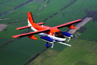
This acquisition effort is supported by the Institute of Flight Guidance (IFF) of the Technical University of Braunschweig, which owns a research aircraft, a Dornier Do128-6 with a wide range of navigational and atmospheric sensors.
This article describes some of the initial development work in support of Braunschweig’s GBAS initiative.
Getting Ready
The first preparatory test trials were performed in the autumn of 2005 without GBAS-capable equipment. Four stationary reference receivers collected GPS data while a number of ILS approaches were flown.
During postprocessing, we calculated deviations of the airborne receivers’ positions from a previously self-constructed (i.e., not released by the air navigation service provider), desired flight path based on waypoints. This desired flight path and the processing after the flights were done with EUROCONTROL’s PEGASUS software and our own postprocessing software.
. . .
Egelsbach Trials
In January 2006 the IFF conducted GBAS flight trials in the vicinity of Frankfurt/Main, Germany, at the Egelsbach Airport under contract with EUROCONTROL, which loaned a multimode receiver (MMR) for the test. With the assistance of the Deutsche Flugsicherung GmbH (DFS), Germany’s air navigation service provider, the Frankfurt GBAS ground station transmitted the required GBAS message types.
. . .
Results
. . . An important aspect of the flight trials was to demonstrate performance of the GBAS philosophy on a so-called “remote airport,” where the GBAS ground station is located at a different place. At Egelsbach the ground station is located at Frankfurt Airport with an approximate distance of 12 kilometers between the GBAS ground station and the landing runway threshold.
A problem with the remote operation of GBAS ground stations is the coverage of the VHF data broadcast (VDB) signal. Due to shadowing problems, no reliable VDB reception existed at Egelsbach airport after passing the decision height of 200 feet, which corresponds to CAT I operations.
The flight trials have demonstrated that, even during highly dynamic maneuvers, the desired flight path can be followed without difficulty. Further investigations will be made regarding the VDB coverage of the GBAS ground station as well as the influence of the aircraft thereupon.
For the complete story, including figures, graphs, and images, please download the PDF of the article, above.
Acknowledgements
The results presented here are partly archived during campaigns financed by and using equipment from EUROCONTROL. Special thanks to C. Butzmuehlen (IntegNav GmbH) and Pildo Labs for their work during data analysis, to DFS for the procedures, Andreas Lipp for his assistance, and messWERK GmbH for the visualization.


![Indra Navia Leading the Evolution Towards Dual-Frequency GBAS Some of the equipment that makes up Indra’s GBAS; Image courtesy Indra[87]](https://insidegnss.com/wp-content/uploads/2025/11/Some-of-the-equipment-that-makes-up-Indras-GBAS-Image-courtesy-Indra87-150x150.jpg)


