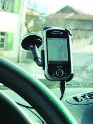
 Device mounted on a Fideriser Heuberge AG bus
GPS was introduced to much of the consumer market during the 1990s in the form of car navigation systems. This was the era of standalone navigation solutions.
Today, network-based navigation systems are common and, in the context of commercial vehicle tracking, usually required. One application in this field is fleet management for taxi companies. A human operator at the service center coordinates the pickup of the next customer by the closest vehicle.
The goal of the project described in this article was to support a bus company, Fideriser Heuberge AG, with a fleet of vehicles operating on narrow, curving roads in a remote valley of Switzerland. In the course of this project, we developed and implemented a system that allows every bus driver to see around “blind” corners. In effect, we wanted to provide the driver with a kind of proximity alert whenever another bus is approaching around the next corner.
A Step Ahead
The project discussed here goes a step beyond the example of taxi fleets mentioned earlier. In the Fideriser Heuberge system, the task of the person at the service center is carried out by a computer, which dispatches the incoming messages and broadcasts the information to every device that is currently on air.
This methodology, however, implies the implementation of management software for connections and algorithms to detect any loss in communications. If a connection is lost, the system needs to reestablish the link automatically.
In the operation area of the bus company the only wireless coverage available is by means of GSM or satellite communication. Because satellite communication costs several times as much as GSM, the choice seemed obvious: GSM, or general packet radio service (GPRS), to be more specific.
A proprietary radio system was out of consideration because of the high amount of engineering resources that would have been needed. As client hardware on board the buses, we used a personal digital assistant (PDA) containing all the needed parts that are indispensable to providing the necessary functionality. These are, namely, a 20-channel GPS receiver, GPRS modem, display, and a sound device.
Proprietary hardware was considered too expensive. Furthermore, the physical requirements for the hardware were very high because of the challenging environment in a frequently vibrating bus.
In hilly and mountainous terrain, clear views of the road are not available at all places. Traditionally, mountain buses sound a horn before turning around a potentially dangerous corner. Besides the danger of collision, finding room to pass oncoming traffic on narrow roads can be difficult. However, in an area with no private transportation, all vehicles operating on the road network can be known and equipped with a GPS/GPRS tracking device.
Past approaches to tracking vehicles and goods usually send positions and other parameters of interest to a data server where a human scheduler can take advantage of this information to manage the vehicles.
In contrast to such fleet management applications, the Fideriser Heuberge system automatically redistributes the real-time positions of all vehicles to every vehicle in the fleet. This allows each driver to visualize the positions of oncoming vehicles well in advance. Acoustic warnings produced by the PDA further alert the driver to the presence of oncoming vehicles in the immediate vicinity.
The bus company has a fleet of 10-12 buses, which are used as necessary, that is, without a fixed time schedule. So, the software had to deal with various combinations and numbers of buses used at any given time. This required software capable of managing all devices dynamically, adding and removing devices as they, respectively, begin transmitting position reports or go out of service and disappear from the air.
For the rest of this story, please download the complete article using the PDF link above.


