Magazine Section Archives - Page 57 of 66 - Inside GNSS - Global Navigation Satellite Systems Engineering, Policy, and Design

Magazine Section

July 1, 2011

Verification Testing

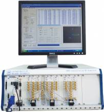
A GNSS signal simulator is mainly used to simulate GNSS signals transmitted by navigation satellites, propagated through the Earth’s atmosphere, and received by the receiver antenna. A simulator provides a convenient signal source for the test and validation of receiver function and performance and can also be used in GNSS experiments and studies of signal/data processing algorithms.

Read More >

By Inside GNSS

GPS Interference Testing

Anechoic chamber test site at U.S. Naval Air Systems Command (NAVAIR) facility in Patuxent River, Maryland

Interference can pose a threat to the reception of GNSS signals in a variety of ways. Even low-level signals have the potential to interfere with GNSS receivers, which require very high sensitivity for acceptable performance due to the extremely low received GPS signal power at the Earth’s surface.

Read More >

By Inside GNSS
May 24, 2011

GNSS Hotspots | May 2011

One of 12 magnetograms recorded at Greenwich Observatory during the Great Geomagnetic Storm of 1859
1996 soccer game in the Midwest, (Rick Dikeman image)
Nouméa ground station after the flood
A pencil and a coffee cup show the size of NASA’s teeny tiny PhoneSat
Bonus Hotspot: Naro Tartaruga AUV
Pacific lamprey spawning (photo by Jeremy Monroe, Fresh Waters Illustrated)
“Return of the Bucentaurn to the Molo on Ascension Day”, by (Giovanni Antonio Canal) Canaletto
The U.S. Naval Observatory Alternate Master Clock at 2nd Space Operations Squadron, Schriever AFB in Colorado. This photo was taken in January, 2006 during the addition of a leap second. The USNO master clocks control GPS timing. They are accurate to within one second every 20 million years (Satellites are so picky! Humans, on the other hand, just want to know if we’re too late for lunch) USAF photo by A1C Jason Ridder.
Detail of Compass/ BeiDou2 system diagram
Hotspot 6: Beluga A300 600ST

1. DON’T BLAME GPS
Humboldt-Tolyabe National Forest, Nevada USA
√ In the Pacific Northwest, in-car navigators often indicate “short cuts” through wilderness mountains—with tragic results. One victim survived 49 days before rescue in May. (Reports blamed GPS – not digital maps or wireless communication.) GPS.GOV straightens out misperceptions, for those who need a guardian angel, but just get a signal.

Read More >

By Inside GNSS
[uam_ad id="183541"]
[uam_ad id="183541"]

A Target — Possibly Moving

Up here in the beautiful Pacific Northwest — yes, the sun is shining; hence, my enthusiasm — we have a wealth of wildlife. It goes nicely with the splendid landscape.

We have birds of all songs and colors. (Migratory Western tanagers passing through right now.) A selection of bears, mountain lions, the occasional wildcat. A surfeit of deer. 

Even buffalo and grey wolves are making their comeback.

Read More >

By Inside GNSS
1 55 56 57 58 59 66
IGM_e-news_subscribe