Global Navigation Satellite Systems Engineering, Policy, and Design
Global Navigation Satellite Systems Engineering, Policy, and Design

 One of 12 magnetograms recorded at Greenwich Observatory during the Great Geomagnetic Storm of 1859
 1996 soccer game in the Midwest, (Rick Dikeman image)
 Nouméa ground station after the flood
 A pencil and a coffee cup show the size of NASA’s teeny tiny PhoneSat
 Bonus Hotspot: Naro Tartaruga AUV
 Pacific lamprey spawning (photo by Jeremy Monroe, Fresh Waters Illustrated)
 “Return of the Bucentaurn to the Molo on Ascension Day”, by (Giovanni Antonio Canal) Canaletto
 The U.S. Naval Observatory Alternate Master Clock at 2nd Space Operations Squadron, Schriever AFB in Colorado. This photo was taken in January, 2006 during the addition of a leap second. The USNO master clocks control GPS timing. They are accurate to within one second every 20 million years (Satellites are so picky! Humans, on the other hand, just want to know if we’re too late for lunch) USAF photo by A1C Jason Ridder.
  Detail of Compass/ BeiDou2 system diagram
 Hotspot 6: Beluga A300 600ST

1. DISPOSABLE DRONES
Washington, D.C.
One of the first feature articles I wrote as a newly minted GNSS magazine editor 26 years ago was about an advanced rail traffic management system based on GPS that Burlington Northern, with the help of Rockwell Collins, had designed and implemented.
By Inside GNSS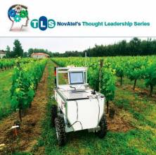
 Francisco Rovira-Más, Agricultural Robotics Laboratory, Universidad Politécnica de Valencia
Now that we have had GNSS-driven precision in the fields for nearly 20 years, with widespread and growing acceptance by farm vehicle manufacturers and farmers, what lies ahead for precision agriculture?
By Inside GNSS
Q: Are there special considerations for dealing with raw GNSS data?
A: Most GNSS users are only interested in position, velocity, and/or time (PVT) information provided by a receiver. In fact, most mass-market GNSS receivers (e.g., those in cell phones or in your vehicle) only provide PVT information along with some supporting data (such as the number of satellites tracked, dilution of precision, course over ground, and so forth).
By Inside GNSS
Global navigation satellite systems provide position, velocity, and time (PVT) solutions to users whose receivers calculate position based on one-way ranging from satellites. As is well-understood, a key step in the positioning process involves a determination of the difference between the time of signal transmission identified in the satellite’s broadcast navigation message and the time of its reception by user equipment.
By Inside GNSS
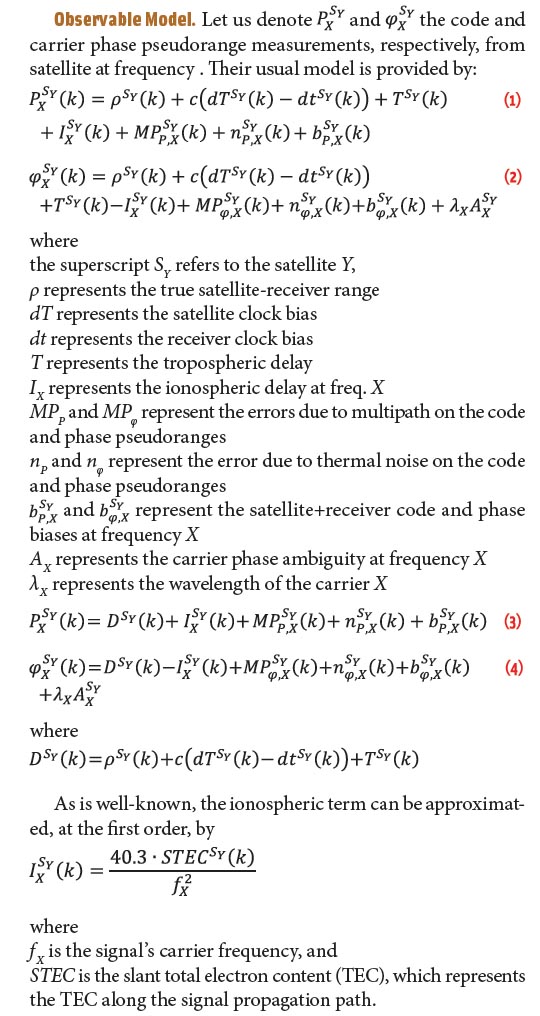
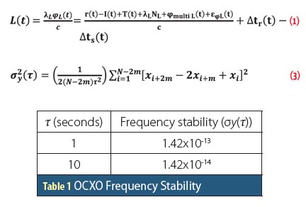
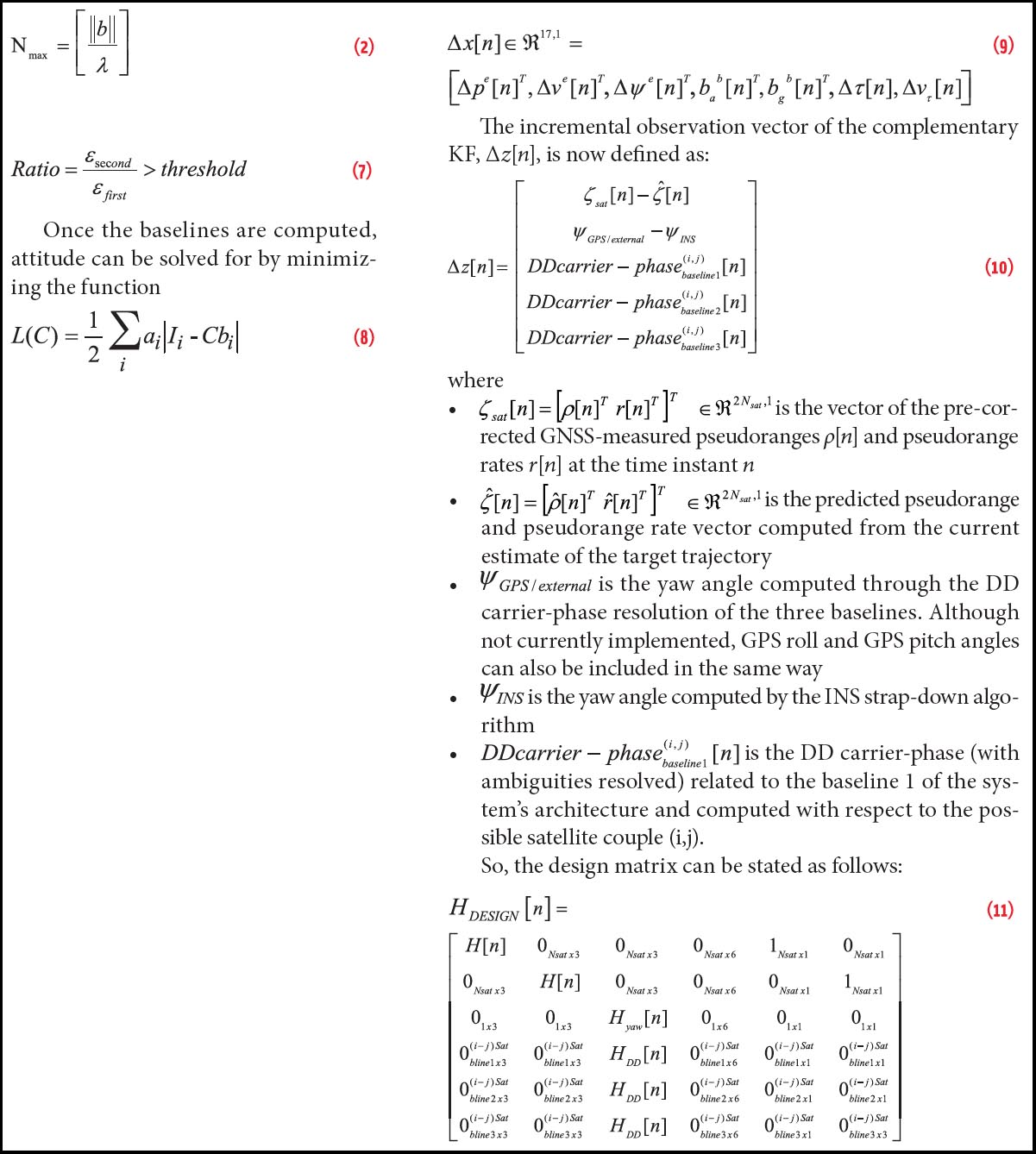 Equations 2, 7, 8, 9, 10 & 11
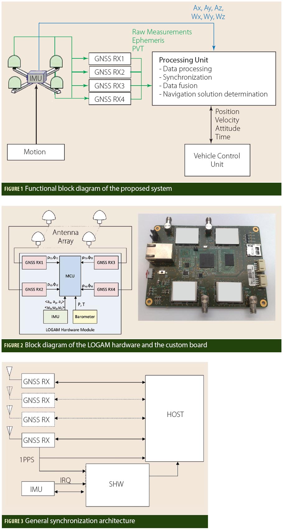
Unmanned aerial vehicles (UAV) are finding increased application in both domestic and governmental applications. Small UAVs (maximum take off weight less than 20 kilograms) comprise the category of the smallest and lightest platforms that also fly at lower altitudes (under less than 150 meters).
Designs for this class of device have focused on creating UAVs that can operate in urban canyons or even inside buildings, fly along hallways, and carry listening and recording devices, transmitters, or miniature TV cameras.
By Inside GNSS

Working Papers explore the technical and scientific themes that underpin GNSS programs and applications. This regular column is coordinated by Prof. Dr.-Ing. Günter Hein, head of Europe’s Galileo Operations and Evolution.
By Inside GNSS
After three years in Chapter 11, the company whose planned wireless broadband system threatened to overload GPS receivers across the United States is preparing to emerge from bankruptcy.
By Dee Ann Divis