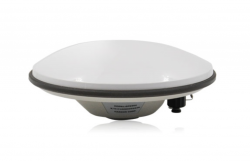
Industry View category

August 2, 2017

Lockheed Martin Invests $350 Million in “Factory of the Future” for Satellite Production

Lockheed Martin’s planned satellite integration facility, the Gateway Center, is slated for completion in 2020. Photo: Lockheed Martin.

Preliminary construction is underway on a new, $350 million Lockheed Martin facility that will produce next-generation satellites. The new facility, located on the company’s Waterton Canyon campus near Denver, Colorado is the latest step in an ongoing transformation, infused with innovation to provide future missions at reduced cost and cycle time.

Read More >

By Inside GNSS
August 1, 2017

STATSports Selects Taoglas to Connect to GPS-based Apex System

Taoglas’ AGGBP.25B two-stage 28 dB Active GPS Patch Antenna Module. Photo: Taoglas.

Taoglas, a Wexford, Ireland-based provider of automotive and Internet of Things (IoT) antenna products, today announced that STATSports has selected Taoglas to provide antenna solutions for its new Apex line of GPS-based sports performance monitors.

Read More >

By Inside GNSS
[uam_ad id="183541"]

Polynesian Exploration Launches Integrated Navigation System

The POLYNAV 2000 is one of the company’s integrated navigation systems. Photo: Polynesian Exploration Inc.

Polynesian Exploration Inc., a San Jose, California navigation startup, has launched its high-accuracy navigation solution for demanding applications such as autonomous driving and UAVs.

The POLYNAV 2000 is designed to deliver high accuracy position, velocity and attitude whether the platform is static or moving. The solution features multiple satellite constellations (GPS/GLONASS/BeiDou/Galileo), multiple frequencies real time kinematic (RTK) L1 & L2, multi-antenna signal processing, tactical grade sensors, and high dynamic tolerance.

Read More >

By Inside GNSS
[uam_ad id="183541"]

Rohde & Schwarz and MediaTek present world’s first test solution for A-BeiDou LBS

The R&S TS-LBS is a test system for testing GNSS and network-based LBS. Photo: Rohde & Schwartz.

Rohde & Schwarz and MediaTek have successfully completed the verification of location based services (LBS) in the U-plane and C-plane for A-BeiDou (Assisted BeiDou), China’s GNSS satellite positioning system. The R&S TS-LBS test solution is designed to allow mobile manufacturers, chipset manufacturers, test houses and network operators to verify chipsets and mobile devices in order to obtain permission to operate them in a particular network.

Read More >

By Inside GNSS
July 21, 2017

Septentrio’s GNSS Receiver First to Record Scintillation on Galileo Signals in Antarctica 

PolaRx5S GNSS reference receiver. Photo: Septentrio

At the end of last year, the DemoGRAPE consortium observed for the first time ever, ionospheric scintillations on Galileo signals in Antarctica, using Septentrio’s PolaRx5S GNSS reference receiver.

DemoGRAPE investigates improvement of high-precision satellite positioning with a view to developing scientific and technological applications in Antarctica. The new findings were recently announced by Septentrio.

Read More >

By Inside GNSS

Rohde & Schwarz Launches Compact, Lightweight R&S ZNLE Vector Network Analyzer

The R&S ZNLE vector network analyzer. Photo: Rohde & Schwarz

Rohde & Schwarz has launched the R&S ZNLE vector network analyzer to address the requirements of customers looking to perform RF measurements to characterize components such as antennas, attenuators, filters and PCBs. The new standalone instrument weighs 6 kilograms and has a footprint of just 408 millimeters x 235 millimeters, saving up to two thirds of space on the workbench compared with competitive VNAs, according to the company.

Read More >

By Inside GNSS

Data Collecting Program for Mobile GNSS Field Data Set taking Place in Japan

Mobile GNSS Field Data Set being tested in the winter. Photo: Lighthouse Technology and Consulting

Lighthouse Technology and Consulting Co., Ltd is proceeding with a program to collect precise GNSS data on major highways in Japan. The data is an inevitable “must use” tool for high precision positioning systems used in automated driving vehicles.

While the major part of autonomous driving systems consists of sensors and image recognition technologies, satellite positioning is also a key element used for complementing the precise current position.

Read More >

By Inside GNSS
July 8, 2017

Trimble Catalyst Now Offering High-Accuracy, On-Demand Positioning-as-a-Service

Trimble Catalyst software-defined GNSS receiver for Android devices. Photo source: Trimble.

Trimble just announced that its Trimble Catalyst software-defined GNSS receiver for Android devices is now available through the company’s global distribution network. Customers can now access Positioning-as-a-Service to collect geo-location data with Trimble or third-party apps on smartphones, tablets and mobile handhelds.

Read More >

By Inside GNSS
July 6, 2017

Sygic Incorporates Augmented Reality Into its GPS Navigation App

Sygic has added a new augmented reality (AR) feature to its advanced GPS navigation app. Photo source: Sygic.

Bratislava, Slovakia-based Sygic has added a new augmented reality (AR) feature to its advanced GPS navigation app. More than 200 million Sygic users worldwide can now engage with AR for an improved navigation experience on the road, the company said.

Sygic’s new AR feature uses a smartphone’s GPS and camera to implement an augmented reality-powered GPS navigation system. With the AR feature, drivers no longer need to follow a map on their phones. Instead, they’re guided by a virtual path on the smartphone camera preview.

Read More >

By Inside GNSS
1 39 40 41 42 43 73
IGM_e-news_subscribe