Main Categories

July 2, 2011

FCC Invites Comment on LightSquared Interference to GPS

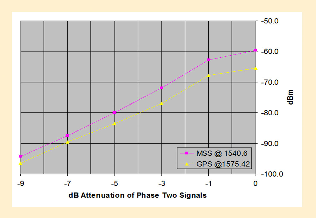
Individuals and organizations wishing to comment on the recently released technical working group (TWG) report on LightSquared’s interference to GPS as well as the company’s proposal for dealing with the problem have until July 30 to submit statements to the Federal Communications Commission (FCC).

In a release dated June 30, the agency noted that the TWG effort “identified significant technical issues” related to potential LightSquared interference in the upper portion of the L-Band, next to the band used by GPS.

Read More >

By Inside GNSS

Cars on the Road!

FIGURE 1: System architecture

Cooperative vehicle safety applications should preferably have two-meter horizontal accuracy and six-meter vertical accuracy, all with a 95-percent availability. The solution must be developed to incorporate lower-cost sensor options, specifically, lower-cost inertial measurement units that can be generally characterized by the gyro drift of 100 degrees per hour and an accelerometer bias force of twice its mass times gravity (two milligals).

Read More >

By Inside GNSS

GLONASS-K for Airborne Applications

FIGURE 1: GPS/GLONASS L1 frequency band

As is well known, Galileo will become the European complement to the U.S. Global Positioning system.

But what about Russia’s GLONASS?

Although this constellation has been in operation for nearly three decades, the limited number of available satellites along with an uncertain governmental commitment to GLONASS performance until recent years had seriously restricted its use for aviation.

Read More >

By Inside GNSS
[uam_ad id="183541"]
July 1, 2011

Verification Testing

A GNSS signal simulator is mainly used to simulate GNSS signals transmitted by navigation satellites, propagated through the Earth’s atmosphere, and received by the receiver antenna. A simulator provides a convenient signal source for the test and validation of receiver function and performance and can also be used in GNSS experiments and studies of signal/data processing algorithms.

Read More >

By Inside GNSS

GPS Interference Testing

Anechoic chamber test site at U.S. Naval Air Systems Command (NAVAIR) facility in Patuxent River, Maryland

Interference can pose a threat to the reception of GNSS signals in a variety of ways. Even low-level signals have the potential to interfere with GNSS receivers, which require very high sensitivity for acceptable performance due to the extremely low received GPS signal power at the Earth’s surface.

Read More >

By Inside GNSS
June 30, 2011

USA Challenge Competition Seeks Satellite Navigation Apps

This is a 1993 photo of Walter, a German astronaut. He exemplifies the fearless approach to experimentation and the spirit of fun that we are looking for (DLR photo)

[Updated June 30] Lucky you – you have three extra days to submit your GNSS application idea to the USA Challenge! The extended deadline is midnight Sunday (Europe) or 3 P.M. (Pacific time) on July 3.

Right now, some team is hard at work in a basement, an office, a dorm room or a lab. They are about to come up with a new, useful and commercially viable idea for a satellite navigation application or location based service.

Read More >

By Inside GNSS
[uam_ad id="183541"]

First Encounters: Asteroid MD 2011 Meets the GPS Constellation

MD 2011 trajectory (NASA)

A schoolbus-sized asteroid grazed the Earth’s atmosphere around 1:00 P.M. (EDT)  on June 27. It was 7,600 miles (12,300 km) away at its closest point, at which time it veered away across the South Atlantic Ocean.

It actually passed through the GPS constellation, alerting us to the vulnerability of our vital PNT space vehicles. We can now add asteroids to the the list of GNSS collision risks that already includes other satellites and space debris.

Read More >

By Inside GNSS
June 26, 2011

Airport Authority of India Says GAGAN Satellite is in Position

Detail of India’s GAGAN system, from a presentation by Dr. S.V. Kibe. For full diagram:

The communications satellite that carries India’s GPS-Aided Geo Augmented Navigation (GAGAN) system has been positioned, according to major news sources in India.

"The initial phase is now over. The satellite is now in position," Airports Authority of India chairman V.P. Agarwal said at a New Delhi workshop on aviation safety.

"We are now going through the certification stage of the Satellite-Based Augmentation System (SBAS) and we will have certification of the system by June 2013." he said, according to reports.

Read More >

By Inside GNSS
June 25, 2011

Intermodulation Effects: Another Perspective on LightSquared Interference to GPS

Much of the research into the possible effects of the planned LightSquared cellular broadband transmissions near the GPS L1 band have focused on the saturation of the front end of GPS receivers caused by the high power of the terrestrial LightSquared base stations. In this article, an engineer with a long history in broadcast digital television takes a look at the likely effects on GPS receivers of third-order intermodulation products created by the LightSquared signals.

Read More >

By Inside GNSS
IGM_e-news_subscribe