GPS Archives - Page 67 of 138 - Inside GNSS - Global Navigation Satellite Systems Engineering, Policy, and Design

GPS

Using Unmanned Systems to Fight Wildfires

Image captured by an onboard Infra-red camera during the West Virginia demonstration

Large wildfires can create their own weather and a dynamic, uncertain environment, and that is one of the reasons they’re so dangerous, says Manish Kumar, an Associate Professor in the Department of Mechanical, Industrial, and Manufacturing Engineering at the University of Toledo.

Read More >

By Inside GNSS

Unmanned Innovations Top DoD Wish List

The U.S. Defense Department (DoD) is launching a search for innovative technologies to help U.S. forces to maintain their advantage in the face of gains by potential adversaries, tighter budgets, and an increasingly complex landscape of security challenges.

At the top of the agency’s wish list are advances related to unmanned systems, including miniaturization and robotics as well as systems that can operate more autonomously.

Read More >

By Inside GNSS
[uam_ad id="183541"]
November 17, 2014

Europe Prepares Its Part of GNSS-Enhanced Search & Rescue Service

Cospas–Sarsat’s extension to MEOSAR (Medium Earth Orbit Search and Rescue) will extend its search and rescue coverage (the area outlined in red). On the ground the Galileo programme is contributing a Toulouse-based test bench, and a networked trio of MEOSAR ground stations – known as Local User Terminals (LUTs) – to cover Europe, based in Svalbard in the Norwegian Arctic, Cyprus and the Canary Islands. Existing LUTs are distributed on a per country basis, but it is an advantage of MEOSAR that fewer ground stations will be needed for greater coverage. Cospas-Sarsat illustration

The European Space Agency (ESA) has announced completion of tests that indicate the readiness of the European component of a modernized, GNSS satellite–aided search and rescue service known as Cospas-Sarsat.

ESA has completed construction and testing of a trio of located on three islands at the far corners of the continent, ready to pick up distress calls via satellite from across Europe and its surrounding waters.

Read More >

By Inside GNSS

Reliable GPS-Based Timing for Power Systems

Efficient power transmission and distribution would benefit from synchronized near–real-time measurements of voltage and current phasors at widely dispersed locations in an electric power grid. Such measurements also could enable effective real-time system monitoring and control, which are considered to be the key to preventing wide-scale cascading outages like the 2003 Northeast Blackout.

Read More >

By Inside GNSS

Evaluating the Performance of Navigation Payloads

As a navigation satellite transmits multiple signals on single frequency (e.g., Open Service and Restricted Service over L5 Band), these are combined on a common carrier to comprise a composite signal. This composite signal passes through navigation payload subsystems such as an up-converter, traveling wave tube amplifier (TWTA), filters, and so on. These subsystems may introduce adverse effects on the signal, such as amplitude and phase distortion, nonlinear effects, gain imbalance, IQ imbalance, and phase noise.

Read More >

By Inside GNSS

Higher Aspirations for GNSS

GPS Space Service Volume (SSV) Requirements/Performance Parameters

New space missions such as the robotic repair and recovery of damaged or errant communication satellites may become possible with the aid of an emerging class of receivers that is able to use GPS signals for navigation in orbits thousands of kilometers above the middle Earth orbit (MEO) GPS constellation itself.

Read More >

By Dee Ann Divis
[uam_ad id="183541"]
November 14, 2014

First GPS III Launch Slips to FY17

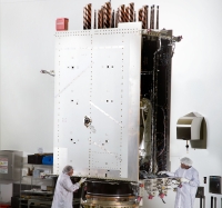
GPS III core structure at Lockheed Martin facility. Lockheed Martin photo

The launch of the first GPS III satellite could slip to as late as March 2017, further delaying a modernization program that already has been pushed back repeatedly by budget cuts and technical problems.

“The first GPS III launch is tentatively considered for the first half of FY17, based on booster availability and Air Force launch priorities,” a spokesman for the Space and Missile Systems Center told Inside GNSS.

Read More >

By Inside GNSS

Topcon Engineers Track New GLONASS Signal

Implementation of code-Phase structures for GLONASS signals ?/?, L2C and L3

Topcon Positioning Group has announced that its latest GNSS reference receiver has tracked a new signal from the GLONASS constellation.

The GLONASS-M 55 satellite was launched in June and is equipped
with an experimental payload capable of transmitting CDMA signals in the
Russian GNSS system’s L3 frequency band centered at 1202.025 MHz. According to the company, Topcon engineers successfully tracked the signal using the NET-G5
receiver during a series of recent tests at the Topcon Technology Center
in Moscow, Russia.

Read More >

By Inside GNSS
November 6, 2014

Tallysman Launches Smart GPS-GLONASS Antenna

Tallysman has introduced the TW5340 “smart” antenna that pairs Tallysman‘s Accutenna technology with STMicroelectronics’ Teseo II GNSS receiver.

The TW5340 is a multi-constellation GNSS antenna that provides simultaneous GPS/GLONASS/SBAS reception and is designed for use in professional grade applications such as precision timing, network synchronization, or low-current  and tracking/positioning applications.

Read More >

By Inside GNSS
1 65 66 67 68 69 138
IGM_e-news_subscribe