
Speaking at a special EGNOS Workshop, Fiametta Diani, head of marketing at the EU Agency for the Space Program (EUSPA), described where Europe’s GNSS augmentation system is going, in the air, on land and at sea.
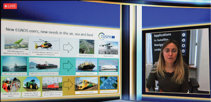
The European Geostationary Navigation Overlay Service (EGNOS) is Europe’s regional satellite-based augmentation system (SBAS). In 2011, EUSPA (then GSA) officially launched the EGNOS Safety-of-Life Service with aviation as a major priority area of application. Ten years on, EUSPA Marketing Head Fiametta Diani said, “In aviation, we have reached the amazing situation where we have almost 800 EGNOS approaches available, and we have EGNOS embedded in the avionics of almost 40% of our EU fleet.”
Safe and Clean Aviation
“We now have 46 EGNOS approaches for helicopters,” Diani announced, “especially in emergency and medical flights. But we want to go a step forward. We are now working very hard to bring EGNOS into the small aerodromes, the ones that are not equipped with other tools for air navigation. We have more than 2,000 of these small airports in Europe that have no or limited ground infrastructure.”
EUSPA’s recently published safety assessment guidelines for small airports represent a new, important achievement, Diani said. “We created these guidelines working together with EASA [European Union Aviation Safety Agency] and with the national air service providers, and we are aiming at the first implementation of EGNOS in small aerodromes, already next year [2022].”
The EU Green Deal is a clear expression of the Union’s prioritization of environmental performance at all levels of activity. “We believe EGNOS in aviation is contributing and will contribute even more to the Green Deal,” Diani said, “and we see this in at least four specific areas. First, EGNOS permits the possibility to reduce the distance flown, that means shorter trajectories, and accordingly fuel and CO2 emissions savings. Second, we can help to reduce the number of missed approaches. Third, we have more options for closer alternates, in case we have to select another aerodrome for landing.”
Finally, Diani said, EGNOS supports more rationalized conventional radar operations. “We are now also setting up tools that permit us and users and airlines to estimate in a more precise way the fuel and CO2 savings.”
Drones Surge
Diani singled out drone operations as the most promising area for EGNOS development: “I think unmanned vehicles is a steeply growing market, in terms of numbers but also in terms of use cases. More and more, drones are used today in professional domains. A traditional surveyor or geometre once used to do their work with handheld tools, to inspect bridges, for example, and now they use drones. But UAVs are also coming for urban mobility.”
‘REALITY’ is a EUSPA-funded R&D project working to equip drones with EGNOS capabilities. “We are co-investing in this project to prepare drones for urban mobility. Here, the challenge we think is to adapt the manned aviation RNP [required navigation performance] and integrity concept, especially to define the narrow air corridors that are needed for drones,” Diani said.
Sea and Land
Turning to maritime matters, Diani said, “We already have EGNOS in our non‐SOLAS vessels, that is our leisure boats.” SOLAS (Safety of Life at Sea) is an important convention governing merchant ships. “And we also have EGNOS transmission by the current AIS and IALA navigation beacons. To go farther, we want to work for the maritime service in SOLAS vessel navigation, and also in autonomous vessels. EGNOS is complimenting IALA differential GNSS infrastructure. We are on track on our ambition to have our service for maritime, directly from the signal in space. And we have finalized the receiver guidelines, so now the receiver can be prepared.”
EGNOS is widely used in agriculture. Indeed, it is the leading technology used today in precision farming in Europe, Diani said, and also in the traditional surveying segment. “EGNOS and EGNSS in general are also widely used for wagon tracking in rail transport,” she said, “but here we also want to take a step forward, in the near future, we want to see EGNSS and EGNOS in train signaling.”
EUSPA is working to include EGNOS services within the European Rail Traffic Management System (ERTMS). The agency is supporting two ongoing mission studies aimed at defining EGNOS service for rail. “We also have two projects in our ‘Fundamental Elements’ program, that is the program for the development of receiver technologies, and we have also updated our rail signaling road map to include EGNOS, working with our main rail stakeholder associations.”


