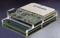
Applanix has announced the availability of a high altitude tactical mapping option for its DSS RapidOrtho system as well as the integration of the Trimble BD960 GNSS receiver module for its POS AV airborne position and orientation system.
With the GNSS module, POS AV products now support GPS L1/L2 and GLONASS L1/L2 processing, both in real-time and post-mission. The BD960 will also be able to receive and process the next-generation GPS L2C and L5 signals.
According to Applanix, with the Trimble module, POS AV will provide improved operational efficiency and robustness for direct georeferencing of sensors employed for airborne mapping, including LIDAR, synthetic aperture radar (SAR), and digital or film cameras.
The processing of signals from both GPS and GLONASS satellites will increase the speed and reliability of ambiguity fixes. For airborne surveying, the extra GLONASS satellites can also provide an advantage by decreasing periods of reduced dilution of precision (DOP), particularly at high latitudes, which can extend the window for maximum surveying accuracy.
POS AV is a hardware and software system with integrated precision GNSS and inertial technology designed for the direct georeferencing of sensors used for airborne mapping. The GNSS module is also available as an upgrade for existing POS AV V5 systems.
Applanix’s tactical mapping operations option combines its DSS RapidOrtho system with a high-performance 250-millimeter focal length AeroLens option, which allows system users to collect rapid, directly georeferenced digital aerial imagery at high altitudes for reconnaissance and planning — particularly for military and security operations. The system produces Ortho Map products of small areas and corridors for planning and monitoring.
Both products are currently available through the Applanix sales network.


