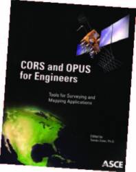
CORS and OPUS for Engineers
Edited by Tomás Soler
PUBLISHED BY THE AMERICAN SOCIETY OF CIVIL ENGINEERS
CORS and OPUS for Engineers
Edited by Tomás Soler
PUBLISHED BY THE AMERICAN SOCIETY OF CIVIL ENGINEERS
CORS and OPUS for Engineers, edited by Dr. Tomás Soler, is the first book systematically introducing the Continuously Operating Reference Station (CORS) and the Online User Positioning Service (OPUS), two major innovations of the National Geodetic Survey (NGS) of National Oceanic and Atmospheric Administration (NOAA).
This monograph collects 22 articles describing a wide range of GPS precise positioning associated with CORS and OPUS. The latter is a user-friendly online positioning tool requiring several local permanent GPS stations. It provides positioning coordinates in two popular reference frames: the International Terrestrial Reference Frame of 2000 (ITRF00) and the CORS96 realization of the North American Datum of 1983 (NAD83).
As a professor of geosciences, I have been using OPUS for a couple of years in my geological classes, as well as in my research. Due to the inherent benefits of obtaining high-accuracy positions using Global Positioning System (GPS), this technology is being increasingly applied to earth sciences. However, most GPS receivers do not directly provide research grade (centimeter or sub-centimeter level accuracy) results. Complex calculations are required to obtain high-precision positions, and thereby high-accuracy displacement measurements.
According to my teaching experience, it is hard to familiarize undergraduates with current “scientific” GPS software packages, such as GIPSY, GAMIT, and BERNESE, within the period of a one-semester course. Additionally, these software packages are updated very frequently, such that an occasional user can hardly catch up the frequent updates.
Several national organizations offer free online GPS data post-processing services, which help solve this dilemma. OPUS is used in my classes because of its high accuracy in the Puerto Rico and Virgin Islands region. Using the free online service, students can speed through the complex aspect of GPS data processing and focus on the application of the advanced technology.
In recent years I offered a Geological Hazards class to undergraduates at the Mayaguez campus of the University of Puerto Rico. GPS is taught in the laboratory section because it has been widely used in the study of natural hazards, such as landslide and subsidence monitoring. We used OPUS as a basic tool for GPS data post-processing. Unfortunately, a comprehensive document about OPUS was not available. We had to hunt for pieces of information from individual papers written by NGS researchers — a very inconvenient process for both students and educators.
CORS and OPUS for Engineers, edited by Dr. Soler, collects the latest available literature describing both the theoretical and empirical research about CORS and OPUS. A large number of students and educators will benefit from this effort. The book includes 22 articles, 9 previously published articles, and 13 new articles. Articles 1, 2, and 4 introduce the “hardware” of the OPUS utility.
OPUS uses CORS stations as ground references and IGS orbits as space control points to achieve high precision at the rover. A researcher may want to understand CORS and IGS orbits and their effects on the accuracy of OPUS solutions. The first article, “Continuously Operating Reference Station (CORS): History, Applications, and Future Enhancements,” addresses the history, major applications of CORS, and plans for the future.
The second article, “Criteria for Establishing and Operating a Continuously Operating Reference Station (CORS),” summarizes the requirements and recommendations for the establishment and operation of GNSS stations in the CORS network. I find this to be one of the most comprehensive documents about CORS monuments and can be used as a guideline for installing new CORS stations.
The fourth article, “A Synopsis of the IGS Orbits Used in the OPUS,” is very short (only three pages in length), but clarifies the worries that may occur in most users. This article shows that errors in current IGS orbits are insignificant for mm-level positioning using GPS.
Articles 3, 5, 6, 8, 10, 11, 12, and 13 introduce the “software” of the OPUS utility. OPUS currently implements two post-processing methods, static (OPUS-S) and rapid static (OPUS-RS). These eight articles highlight the insights as well as the performance of both methods. Each article is self-contained, but they complement each other and give a comprehensive picture of the software design, reference selections, statistics of accuracy, and error message of OPUS-S and OPUS-RS.
Article 12, “Accuracy of Rapid Static Online Positioning User Service (OPUS-RS) Revisited,” published here for the first time, introduces a new NGS product: an interactive Web utility that enables users to view the predicted accuracy of OPUS-RS solutions at any site covered by the current CORS network managed by NGS. This would be a very useful tool for individual users as well as organizations planning to install CORS networks.
In my own experience with OPUS, I have found that this Web utility reports to provide unbelievably high accuracy in Puerto Rico: 0.6 centimeter horizontal and 2.0 centimeters vertical accuracy for one-hour sessions, and 0.9 centimeter horizontal and 3.6 centimeters vertical accuracy for 15-minute sessions. For two years I have been monitoring an active landslide using GPS in Puerto Rico with a single reference-rover pair.
The baseline length is 130 meters. The true landslide displacements are well known at the sub-millimeter accuracy. I submitted the two-year landslide GPS data (one-hour sessions and 15 minute sessions) to OPUS and calculated the accuracy of OPUS-RS solutions. Surprisingly, I got even higher accuracy in horizontal components and slightly larger accuracy in vertical component.
Now, back to CORS and OPUS for Engineers.
Articles 7, 9, and 14 give very detailed instructions about how to edit a problematic RINEX (Receiver Independent Exchange Format) file and fix a poor OPUS run. Most probably, an OPUS user does not need to edit a RINEX file. But it is absolutely necessary for students in a geodesy major to be familiar with TEQC (Translate, Edit, and Quality Control) commands, the most popular GPS data editor tool used in the GNSS community. These three articles can be used as tutorials for TEQC training.
Other articles cover wide topics related to OPUS and CORS, including network adjustment to OPUS solutions in land surveying, real-time kinematic GPS, transforming positions and velocities between ITRF2000 and NAD83, the NGS Horizontal Time-Dependent Positioning (HTDP) software, and transforming OPUS ITRF00 coordinates to WGS84.
The articles included in this monograph are written at the appropriate level for the intended audience: senior undergraduate and graduate students, educators, academic researchers, and professional engineers working on surveying, GIS, and mapping applications. CORS and OPUS for Engineers is the first book that would be an appropriate self-contained textbook for a senior undergraduate or graduate geodesy course in online GPS data processing.
As in any new publication a scrupulous reader may find a few editing mistakes, for example, a paragraph in page 22 was duplicated. However, these few minor errors do not detract from the scientific correctness of the book’s contents.
Overall, CORS and OPUS for Engineers is an excellent reference — much needed by scientists, geodesists, engineers, and land surveyors who are currently using or plan to incorporate OPUS into their day-to-day operations. Moreover, recently OPUS-S became available to the international GPS community, opening a new alternative for timely and efficiently process GPS data collected by geodetic quality receivers anywhere around the world.


