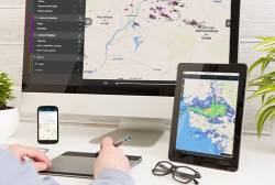
 Sferic Maps empowers emergency management and business continuity professionals with real-time collaboration capabilities to make intelligent weather-related decisions. Photo source: Earth Networks.
Advanced weather data is crucial to safeguarding business assets from severe weather. For example, energy companies build outage models utilizing their real-time hourly forecasting for every point in the country. These companies can then plan field teams accordingly, and plan drone operations to be conducted after the weather event to assess infrastructure damage that may have occurred.
Advanced weather data is crucial to safeguarding business assets from severe weather. For example, energy companies build outage models utilizing their real-time hourly forecasting for every point in the country. These companies can then plan field teams accordingly, and plan drone operations to be conducted after the weather event to assess infrastructure damage that may have occurred.
Global weather data company Earth Networks recently demonstrated its weather sensing network and solutions for drone operations at AUVSI Xponential in Dallas, Texas. Earth Networks operates a large network of weather sensors, and its Total Lightning Network is the most extensive and technologically-advanced lightning network in the world, according to the company.
During the demonstration at Xponential, Earth Networks showed how advanced weather data can transform the efficiency and safety of drone and unmanned vehicle operations. Businesses in oil & gas, construction, government, energy and other weather-sensitive industries leverage advanced weather data analytics for safe site surveying and inspection with UAVs, better response to disasters and emergencies, and protecting their significant investments in drone or UAV assets.
Some of the capabilities advanced weather data can deliver include:
• Surface Wind Information – Wind speeds are a critical component to deploying smooth drone-based missions and should be factored in the project planning and deployment phases. Ground-based wind sensing can be used as a proxy to boundary layer wind measurement.
• Lightning Data – Knowing where severe weather is anticipated can be used for flight planning, including geo-fencing applications that currently take into account stationary assets and protected air space. Knowing where severe weather can disrupt a mission can augment geo-fencing applications to ensure smooth flight operations.
• Inspection – Companies can combine aerial imagery with historical weather information to assess how weather has impacted their projects or infrastructure. Using predictive analytics, utility companies already develop outage models to deploy field teams to at-risk areas.
• Claim verification – Insurance companies now use data for claim verification. This could be paired with drone services that are validating claims to provide additional data to support a claim decision.
By storing site surveys and historical weather data, companies can gain insight into how weather patterns are affecting their projects and critical assets.
Another solution Earth Networks offers is Sferic Maps, which empowers emergency management and business continuity professionals with real-time collaboration capabilities to make intelligent weather-related decisions, increase response planning lead time and minimize operational downtime.
This weather visualization application combines the Earth Networks weather and lightning observation metrics with powerful data representation, real-time broadcasting, and customized alerting capabilities. In the offering, which is also mobile-enabled, customers can create custom map layers by pasting GeoJSON onto the map. Customers use this to depict the locations of their critical assets, visualize when weather patterns will intersect with those assets, and set up customized predictive alerts that can be sent to personnel managing those assets.


