Despite its formative role in supporting development of the Global Positioning System, the Defense Advanced Research Projects Agency (DARPA) has been hedging its positioning, navigation, and timing (PNT) technology bets for some years as emerging threat scenarios become more sophisticated and widespread.
Despite its formative role in supporting development of the Global Positioning System, the Defense Advanced Research Projects Agency (DARPA) has been hedging its positioning, navigation, and timing (PNT) technology bets for some years as emerging threat scenarios become more sophisticated and widespread.
One of its current initiatives, the All Source Positioning and Navigation (ASPN) program now entering its second phase, seeks to enable low-cost, robust, and seamless navigation solutions for military users on any operational platform and in any environment, with or without GPS.
The ASPN program is developing the architectures, abstraction methods, and navigation filtering algorithms needed for rapid integration and reconfiguration of any combination of sensors. Its goal is to enable rapid adaptation to evolving missions as well as reduction of system integration costs and time-to-market for navigation solutions in general.
DARPA will host a Proposers’ Day Conference tomorrow (June 19, 2012) in support of the upcoming solicitation. The event will take place at the DARPA Conference Center, 675 North Randolph Street, Arlington, Virginia from 1 to 4 p.m., and will provide information on Phase 2 of the ASPN program, address questions from potential proposers, and provide a forum for potential proposers to present their capabilities for teaming opportunities.
Most current navigation systems rely on a combination of GPS and an inertial measurement unit (IMU), and often one or more additional purpose-built aiding sensors, to provide accurate PNT information. However, such systems typically use custom filter solutions for their specific sensors and measurement sources, leading to point solutions that are inflexible to new capabilities, new threats, or mission challenges, according to the agency.
DARPA believes that the quality and robustness of navigation solutions can be significantly enhanced through the use of information extracted from more diverse combinations of aiding sensors, such as LiDARs, laser rangers, cameras, and magnetometers. Moreover, the agency believes that signals of opportunity (SoOPs) from the existing RF background infrastructure and natural phenomena and new sensors and measurement sources amay prove useful for its ASPN effort.
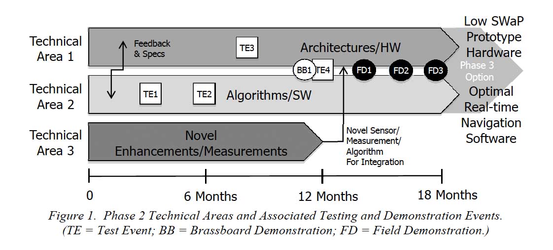
A broad agency announcement (BAA-12-45) released recently by the agency’s Strategic Technology Office (STO) invites proposals in three technical areas (TAs) of interest: TA 1, navigation hardware architectures; TA 2, real-time navigation algorithms; and TA 3, novel navigation measurements.
According to the DARPA announcement, proposed development efforts will ideally lead to system solutions that are: a) adaptable in selecting the optimal set of measurements based on the statistics associated with available navigation inputs; b) flexible to accommodate both synchronous and asynchronous data streams based on available measurements associated with the breadth of possible navigation platforms as well as working with existing sensors; c) extensible to accommodate distributed and/or collaborative navigation processing solutions; and d) scalable to support low size, weight and power (SWaP) implementations.
DARPA expects that Phase 2 will produce real-time algorithms fielded on SWaP-representative prototype hardware that will accept an arbitrary set of inputs, regardless of native application of the sensors used, with robustness and quick re-convergence as sensors and measurements are introduced to or removed from the navigation system.
STO will evaluate hardware architectures and real-time algorithms relative to government-provided optimized navigation solutions for a given set of sensor and IMU inputs for multiple scenarios, including the potential for sea, air, and ground platforms. Testing will include demonstrating the capability of proposed solutions to achieve real-time transitions from 1) one type of IMU to another (e.g. fiber optic gyroscope to a MEMS gyroscope), 2) one aiding sensor type to another that provides similar information (e.g. stereo camera to a video camera), and 3) the addition of new and/or removal of one or more existing sensors.
The BAA presented prospective applicants with an aggressive timeline, presumably anticipating new proposals from companies and individuals taking part in Phase 1, which designed and evaluated architectures and algorithms to accommodate a variety of sensor components across multiple environments and platforms. The first phase demonstrated to DARPA’s satisfaction that an adaptable, plug-and-play capability for navigation systems is achievable.
Phase 2 proposal abstracts are due by Thursday (June 21, 2012) and the final proposal by August 10. Closing date of the BAA is December 10. The accompanying figure shows the overall program timeline and deliverables.


