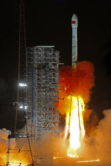
China’s stated goal is to have its BeiDou global navigation satellite system completed sometime in 2020, and the country made big advances toward that goal last weekend when it launched a 20th satellite late on Saturday.
China sent a new satellite of the BeiDou Navigation Satellite System (BDS) into space from the Xichang Satellite Launch Center in Sichuan Province at 10:41 p.m. Saturday, according to the state news agency Xinhua. This latest development marks another step towards completing the vast network it hopes will eventually rival the global positioning system (GPS) run by the United States.
Launched on a Long March-3B carrier rocket, it is the 44th satellite of the BDS satellite family and the first BDS-3 satellite in inclined geosynchronous Earth orbit.
After in-orbit tests, the satellite will work with 18 other BDS-3 satellites in intermediate circular orbit and one in geosynchronous Earth orbit.
Yang Changfeng, chief designer of the BeiDou system, said in a Xichang report this week that the hybrid constellation design, in which three groups of satellites at different orbital regimes work in concert, was an exclusive BDS innovation and the world’s first.
It will increase the number of visible satellites in the Asian-Pacific Region, providing better service for the region, Yang said.
Related Reading: Updated BeiDou Interface Control Document Released; Details on Launch Plans, Message Service Emerge
The launch was the 302nd flight mission for the Long March series of carrier rockets, and the 100th for the Long March-3B. So far, a total of four BeiDou test satellites and 44 BDS satellites have been sent to preset orbits via 36 flight missions launched by Long March-3A and Long March-3B carrier rockets.
The launch on Saturday also marked the first launch of the BDS in 2019. This year, numerous reports say about 7-10 BDS satellites are scheduled to be launched, wrapping up launch missions of all BDS-3 satellites in medium Earth orbit.
China began to construct its navigation system, named after the Chinese term for the Big Dipper constellation, in the 1990s and started serving the Asia-Pacific Region in 2012.
According to Yang, the positioning accuracy of the system has reached 10 meters globally and five meters in the Asia-Pacific Region after the system started to provide global service at the end of last year.
The country has stated previously its plans to have the BDS-3 system completed in 2020. China is also planning to finish building a high precision national comprehensive positioning, navigation, and timing (PNT) system on the basis of the BDS by 2035, according to the state news agency Xinhua.
Yang noted that China is willing to share the achievements of the BDS with other countries. The BDS has been widely used around the world, for example in building construction in Kuwait, precision agriculture in Myanmar, land survey and mapping in Uganda, and warehousing and logistics in Thailand.
BDS began offering a basic service in December, with priority for the Asia-Pacific region and countries along the Belt and Road initiative route.
Beijing has been promoting BDS to countries taking part in the initiative by offering additional services and other incentives if they sign up for the system, states the South China Morning Post. According to a Chinese government white paper on BeiDou from 2016, the system was intended to primarily serve the interests of Belt and Road countries.
Meanwhile, the government has ordered all buses, heavy trucks and fishing boats in China to install BDS for real-time monitoring and tracking, and there are already 70 million BeiDou-linked chips in use in the country.


