 Topcon’s Intel Falcon 8+
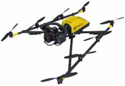
Topcon Positioning Group will distribute Intel Corporation’s Falcon 8+ System, a V-shaped, eight-rotor unmanned aerial system (UAS) in North American markets.
Announced at Intergeo 2016 in Hamburg, Germany, the Intel Falcon 8+ features triple-redundant AscTec Trinity autopilot capability and has full electronic system redundancy, the company said. It also includes the Intel Cockpit ground control and Powerpack smart battery system.
The Intel Falcon 8+ foray into North American markets is a good one, particularly because Topcon has one of the largest UAS reseller and support networks, said Anil Nanduri, Intel Corporation’s UAV Group manager.
"The Intel Falcon 8+ System expands on the success of our rotary-wing UAS offering," said Eduardo Falcon, Topcon GeoPositioning Solutions Group executive vice president and general manager.
Falcon said the UAS offers high-precision GNSS, weight-to-payload ratio, stability in harsh conditions, and is easily exchangeable. Other features include a dual-battery system, comprised of Intel Powerpack smart batteries, which include automatic balancing, storage mode, charging and LEDs that display remaining battery life to meet airline shipping requirements, the company said.
In addition, the Intel Cockpit ground control is water resistant, so operators to plan and execute complex missions with the integration of a single hand, flight control joystick, the company said. The Intel Cockpit ground control also features an Intel-based tablet and supports low-latency digital video links, the company said.
Some Intel Falcon 8+ applications include providing precision data for inspection and monitoring, survey, and mapping applications.


