CGI has formed a new alliance with Vantor to develop AI-enabled spatial intelligence and situational awareness tools for operations where GNSS is denied, degraded or contested.
The collaboration aims to fuse satellite imagery, real-time sensor feeds and onboard computer vision into navigation and targeting solutions that remain reliable when GPS and other GNSS signals are unavailable.
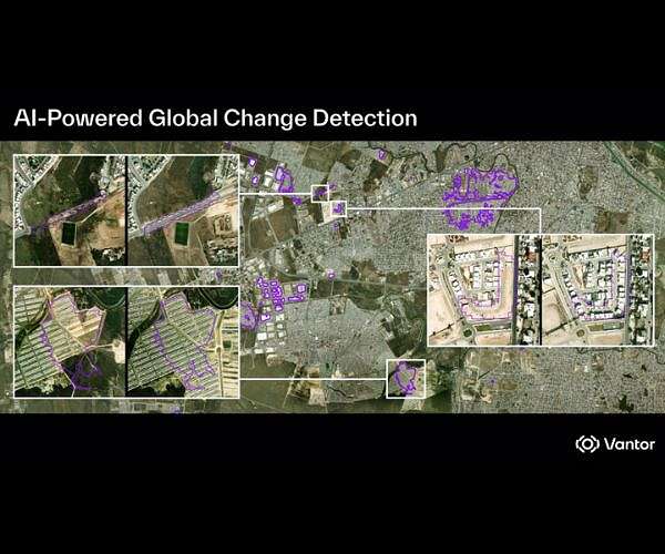
Under a Letter of Intent, the companies plan to integrate CGI’s AI, edge computing and visual analytics platforms with Vantor’s Tensorglobe spatial intelligence environment and Raptor visual navigation software. Tensorglobe is Vantor’s AI-powered spatial intelligence platform that unifies data from satellites, drones and ground sensors into what the company describes as a “living 3D replica of Earth.” Raptor is a vision-based positioning suite that uses onboard cameras and 3D terrain data to estimate aerial position and extract ground coordinates in real time, reducing dependence on GNSS for unmanned systems and other platforms.
Fusing Visual Navigation and Spatial Intelligence
According to the joint announcement, CGI will bring its Machine Vision and SignalSense technologies, along with secure access to satellite data and space-based sensing, while Vantor contributes Tensorglobe’s data fusion and Raptor’s GNSS-resilient navigation capabilities. The goal is to deliver integrated products that provide precise location data, real-time analytics and operational navigation in GNSS-denied or signal-degraded areas, supporting faster decision-making in complex environments.
On the navigation side, integrating Raptor into the joint offering is intended to help users maintain accurate positioning and coordinate generation when GNSS is jammed, spoofed or unavailable—using visual matching against high-resolution 3D terrain models instead of satellite ranging alone. On the intelligence side, Tensorglobe’s ability to orchestrate multi-constellation satellite imagery, airborne ISR and ground sensors into a common operating picture is expected to feed CGI’s AI analytics, supporting mission planning, dynamic monitoring and threat detection.
CGI and Vantor say they will initially target defense, national security and civil government customers in the UK, Europe and allied markets that need AI-enabled edge computing and space-based situational awareness for operations with poor or zero GNSS coverage. The companies also frame the alliance as a way to deliver interoperable and sovereign solutions, aligning with European and allied priorities around resilient PNT, sovereign data handling and reduced dependence on single-source infrastructure.
For GNSS users and system integrators, the partnership fits into a broader trend: using spatial intelligence, visual positioning and alternative signals to harden PNT architectures against jamming, spoofing and outages, while feeding richer context into command-and-control and autonomy stacks rather than treating navigation and ISR as separate problems.


.jpg "Juliana Blackwell To Direct National Geodetic Survey, Oversee Spatial Reference System")
