Held on White Sands Missile Range in south-central New Mexico, the 746th Test Squadron creates GPS EW scenarios during the cost-sharing event, allowing participants to test navigation systems as well as train personnel at a reduced cost.
GENEVA QUINN, LT NICHOLAS GEORGE, KALYN JONES, ORLANDO PADILLA, SEAN ABRAHAMSON 746TH TEST SQUADRON
The 746th Test Squadron (746 TS), part of the United States Air Force (USAF) 704th Test Group (704 TG), recognized there was a need to provide operational and developmental test communities with a cost-effective, operationally realistic venue to facilitate navigation system testing and training objectives. Twenty years ago, the 746 TS started what is now known as Navigation Festival (NAVFEST) to fill that need.
NAVFEST provides low-cost, realistic, Global Positioning System (GPS) Electromagnetic Warfare (EW) scenarios to test GPS-based navigation and alternate navigation systems as well as train personnel in unique GPS-denied environments. The cost-sharing event enables 746 TS and 704 TG to provide a diverse testing and training opportunity for about 96% less than the cost of a standalone program.
The 746 TS is located at Holloman Air Force Base (AFB) in New Mexico. Because of its proximity to White Sands Missile Range (WSMR), the 746 TS can conduct robust open-air GPS testing, minimizing the effects of GPS EW outside WSMR airspace. The location also keeps event costs relatively low, as systems can be deployed to the range with logistical ease.
2024 marks the 20th year the 746 TS has conducted these cost-sharing NAVWAR events. Dubbed NAVFEST 24, this year’s event was held May 6-17, where participants completed eight days of comprehensive Position, Navigation and Timing (PNT) testing in various GPS-challenged environments.
NAVFEST History
The 746 TS has been the pioneer and mainstay of the guidance and navigation test community since its inception in 1959. At that time, precision guidance and navigation was accomplished almost exclusively with inertial technology. The USAF recognized the need to centralize the considerable expertise and investments in manpower and equipment required to create consistent reference standards for these systems. To meet the challenge of testing the more accurate and complex technological advances in navigation systems, the Central Inertial and Guidance Test Facility (CIGTF) was established at Holloman AFB in New Mexico—a seismically quiet and remote location isolated from most cultural disturbances.
The facility was instrumented with the nation’s most complete collection of large precision centrifuges, rate tables and environmental test beds, ideally suited to test and verify inertial guidance and navigation systems of land-based strategic deterrents.
Upon the advent of GPS in the early 1990s, testing GPS guidance and navigation equipment was a logical extension of the CIGTF mission. Now managed by the 746 TS on Holloman AFB adjacent to WSMR, the CIGTF consolidates a full range of low, medium and high-dynamic testing in laboratory, ground, flight, high-speed test track and GPS threat environments all in one location. On October 1, 1990, the CIGTF was designated the Responsible Test Organization (RTO) by Air Force Systems Command (now known as Air Force Material Command) for integrated GPS and Inertial Navigation Systems (INS). In 1991, the GPS Joint Program Office (now part of Space Systems Command) transferred RTO responsibilities for GPS user equipment (UE) to the CIGTF. Since then, the CIGTF has been involved with nearly every GPS acquisition or trade study in the Department of Defense (DOD)—helping to make GPS the “gold standard” for PNT. Fully embracing its expanded role but eager to retain its renowned heritage in the guidance and navigation community, the 746 TS slightly modified its workplace name to the Central Inertial and GPS Test Facility.
Unfortunately, the overwhelming success of GPS led to an over-reliance on the technology—a fact that has not escaped the attention of our adversaries. This has resulted in a foreign-led GPS-disruption industry that persistently permeates military areas of operation, ushering in an age of Navigation Warfare (NAVWAR).
Amid growing concerns of GPS jamming in military areas of operation, testing GPS receivers and antenna systems in a GPS-denied environment has become increasingly important to DOD agencies. The 746 TS responded to this concern by creating a cost-effective venue through which DOD organizations can test equipment or train personnel in operationally realistic GPS-challenged settings.
Originally called JAMFEST, the first event was held in 2004 in a remote part of Holloman AFB. Seven DOD customers participated in this pilot program, proving the general concept of a shared vulnerability environment could work.
Soon after, word of the event spread, and more organizations clamored to participate in the next one. The 746 TS tweaked a few minor event details and prepared to execute another JAMFEST later the same year. This time, however, the Secretary of Defense directed Holloman’s F-117 to undergo an Operational Readiness Inspection (ORI) and asked the 746 TS not to complicate their inspection with on-site GPS jamming. In turn, the 746 TS relocated JAMFEST to the northern part of WSMR, far enough away not to affect the ORI. This proved to be an advantageous move, offering even more opportunities for complex vulnerability scenarios. The event has resided there almost exclusively ever since.
The JAMFEST concept remained virtually unchanged for several years, with the exception of refined jamming scenarios and more earnest participation, not only from DOD entities, but also from NATO partners and commercial organizations.
The increased attention garnered mild concern from the Joint Spectrum Center, a field office within the Defense Spectrum Organization that ensures the effective use of the electromagnetic spectrum. A critical link in the Radio Frequency Approval (RFA) process that grants permission to emit signals on GPS frequencies, the Joint Spectrum Center became uncomfortable with the idea of associating its RFAs with events with the word “jam” in their names. The 746 TS responded by changing the event name to NAVFEST, and the rest is history. (The Joint Spectrum Center has since relaxed this naming convention requirement.)
Objectives/Resources
The overall objective for NAVFEST 24 was to provide a diverse GPS EW environment for NAVFEST participants that included noise EW as well as advanced threat environments. To conduct NAVFEST and accomplish all the 746 TS goals and those of the participants, a majority of the 746 TS squadron resources were used. This required transporting 746 TS resources from Holloman AFB to Stallion Range Center located in the northwest corner of WSMR. Some 746 TS resources used included Land Mobile Radios (LMRs), Government Services Administration (GSA) certified safes for classified customer hardware and documents, government owned vehicles (GOVs), and a majority of the 746 TS personnel.
Creating the EW Environment
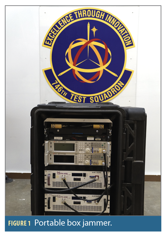
The EW environment was created using a variety of 746 TS assets, including the portable box jammer (PBJ) shown in Figure 1. Each PBJ is a stand-alone EW system with a full suite of GPS EW equipment and 300W adjustable amplifiers. The EW equipment is fully programmable to provide a wide range of EW scenarios and signal modulations. The system records time-tagged amplifier power output for test analysis and time correlation to the test item. Cable loss and antenna gain must be applied to computer-recorded power levels to provide time-tagged effective radiated power (ERP) for GPS L1 and L2 frequencies.
Each system comes equipped with portable generators, a portable antenna mast and tower, and they are all packaged in ruggedized boxes for easy transport and setup. The self-contained systems are currently configured to broadcast on L1 and L2 frequencies but can be adapted to cover other L-Band frequencies if required. Systems host 300W amplifiers and can provide up to 68.9 dBm ERP.
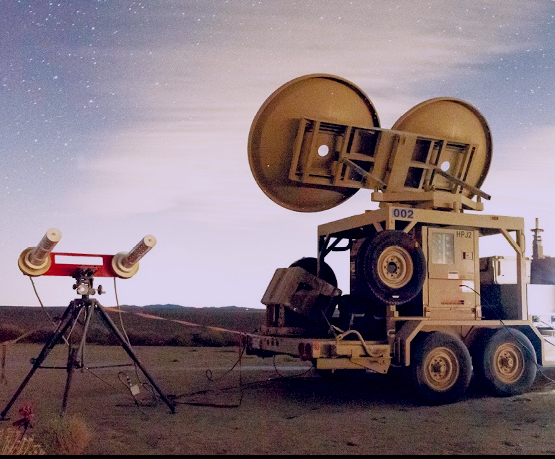
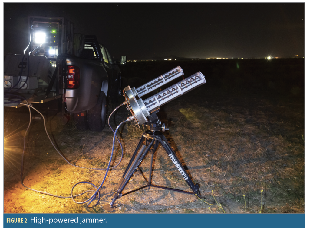
A high-powered jammer (HPJ), another 746 TS test asset, was also used to create the EW environment. HPJs have two form factors: a ruggedized box shown in Figure 2 and an all-inclusive trailer shown in the opening image. The ruggedized boxes allow for easy transport and are equipped with a portable generator and portable antenna mast and tower. The all-inclusive trailer design has the generator, antenna mast, and tower all within the mechanical hardware configuration of the trailer and allows for easy transport to various continental United States range locations. Like the PBJ design, HPJs are fully programmable to provide a variety of EW scenarios and signal modulations.
The systems also record the same time-tagged amplifier power output for test analysis and time correlation to the test item. Like the PBJs, these systems are also L1 and L2 capable, but have 1,000W amplifiers and can provide up to 74.6 dBm ERP.
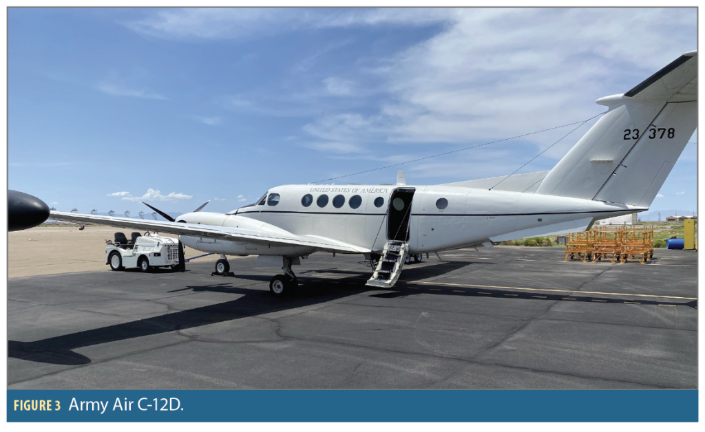
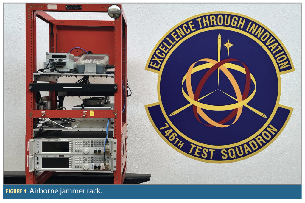
The 746 TS also collaborated with the White Sands Test Center’s Army Air unit located on Holloman AFB to instrument a C-12D, shown in Figure 3, with an airborne jammer (ABJ). The ABJ is manually controlled in flight by a Flight Test Engineer to create a GPS EW environment directed downward and that flies up to 23,500 feet above ground level.
The ABJ rack, shown in Figure 4, is equipped with a 110W amplifier and a signal generator with the same full suite of GPS EW waveforms as the PBJs and HPJs. This system also collects time-tagged amplifier power output. The antenna is mounted to the left wingtip of the C-12D to provide a GPS EW environment.
Reference Data Collection
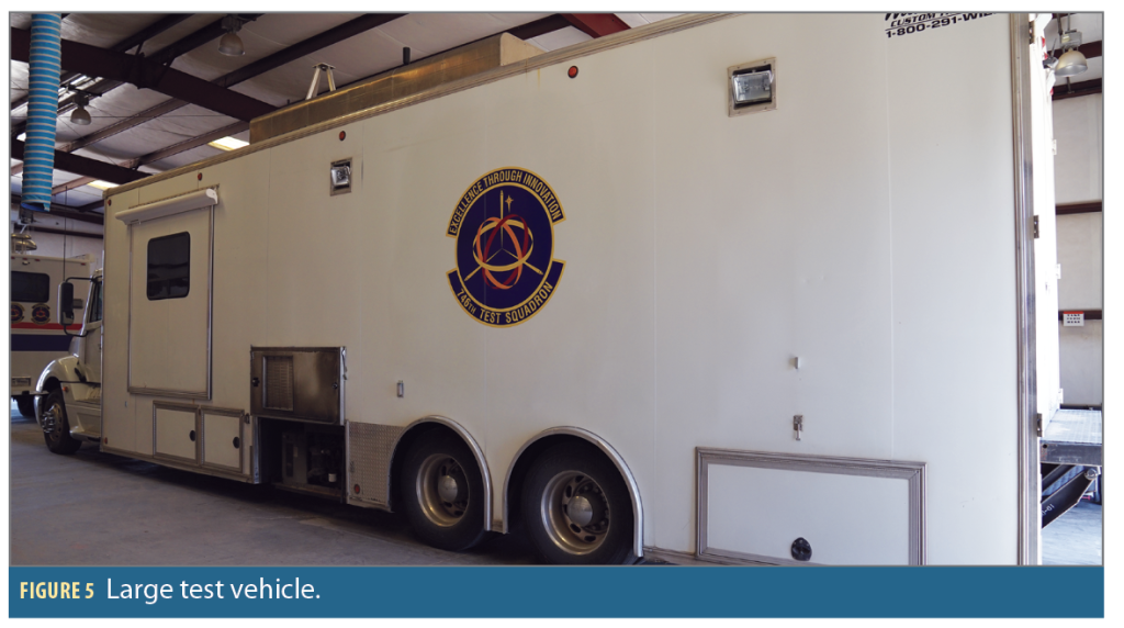
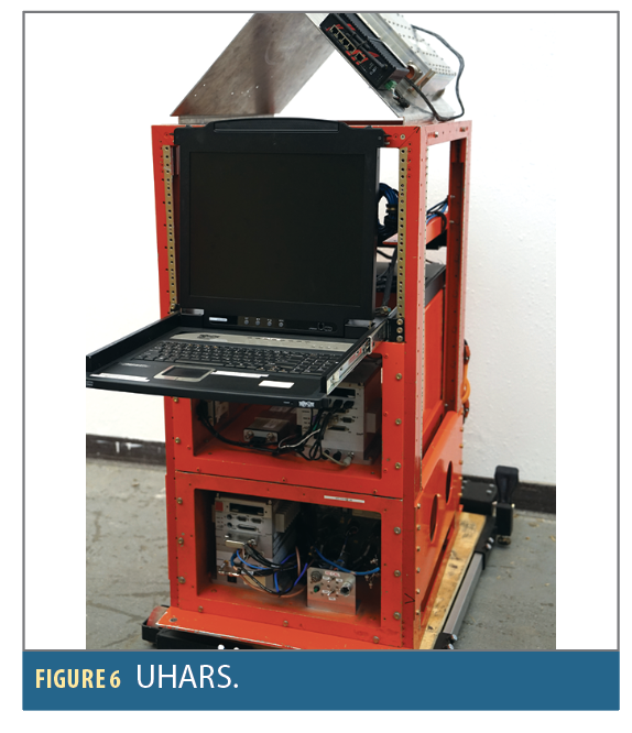
In addition to creating the EW environment, the 746 TS also characterized the environment using its large test vehicle (LTV), shown in Figure 5, instrumented with a unique and highly accurate Time Space Position Information (TSPI) Reference System. Collecting accurate position, velocity and time (PVT) in the NAVFEST environment is challenging because most accurate PNT systems rely on satellite navigation signals transmitted at or near to the GPS frequencies being jammed. To solve this problem, the 746 TS has developed a robust and resilient high accuracy TSPI reference system called the Ultra High Accurate Reference System (UHARS), shown in Figure 6, that can provide an accurate PNT solution across a diverse set of GPS EW environments.
The primary subsystems UHARS includes are:
• High performance navigation-grade inertial navigation system (INS)
• Selective Availability Anti-Spoofing Module (SAASM) Military GPS receiver
• GPS Spatial Temporal Anti-Jam Receiver (GSTAR) Anti-Jam Antenna Electronics Unit + Controlled Reception Pattern Antenna (CRPA)
• NovAtel Global Navigation Satellite System (GNSS) receiver with local base station for differential GNSS post processing
• Locata Non-GPS Based Positioning System
The sensor measurements from all available subsystems are combined using a custom extended Kalman filter/smoother algorithm to produce a high accuracy estimate of the test platform’s position, velocity and attitude. The specialized off-band pseudolite system (Locata) located on a portion of WSMR enables the system to maintain a high level of accuracy even in EW environments that degrade or deny satellite-based navigation.
Nominal performance accuracies of the reference trajectory characterized for specific environments are:
(1) Low sub-meter on ground and flight test vehicles in non-jammed environments.
(2) Meter/sub-meter on ground and flight test vehicles in NAVWAR environments with enhanced low sub-meter performance with Locata.
The Event
The 20th Anniversary NAVFEST test was held across a two-week period from May 6 to 17. Each of the two weeks consisted of four nights of testing, totaling 44 hours of GPS unreliable test time for the 26 participants, which included several DOD organizations, commercial entities, and foreign nations. Several participants arrived the week before NAVFEST to mount equipment on the LTV or set up equipment at various test sites around Stallion Range Center. The 746 TS provided technicians to instrument the LTV with customer equipment before testing began and during test conduct. Other participants arrived on the first day of NAVFEST with their equipment pre-installed in testbeds that consisted of GOVs, specialized test vehicles, aircraft and rental cars. After the test, the 746 TS technicians uninstalled the equipment and prepared it for shipment back to NAVFEST participants.
The 746 TS conducted EW operations for 5.5 hours each night, with a total of 46 GPS EW scenarios tested throughout the event. The scenarios varied in geometry, power density of the environment, threat representation, waveform, and types of EW involved. The 746 TS NAVFEST team collaborated with participants before creating the test scenarios to optimize the test points for each technology. This collaboration established a working relationship among the 746 TS test managers and analysts and the participants. The jammer configuration and the scenarios were designed to meet the participants’ test objectives. Vehicle routes, jammer placement, relocation time, and setup times were taken into consideration when trying to maximize the amount of test time each night.
The 746 TS NAVFEST team established varying scenarios for each night. Participants were able to collect data in environments that produced upwards of 90+ dB jammer-to-signal ratio (J/S) as well as in environments where jammer geometry was paramount instead of high J/S levels. This diverse scenario matrix permitted participants with varying levels of technical readiness to achieve their objectives simultaneously.
NAVFEST 24 was a significant event that incorporated many important lessons learned from previous renditions. To enhance operational security, the Air Force Office of Special Investigations was brought in to provide counterintelligence support. NAVFEST 24 was also rescheduled from March to May, allowing for an increase in favorable weather, which in turn enabled customers to enjoy more test days without impacting participation in other events. To ensure smooth operations and customer accountability, detailed maps were created, outlining routes and common rally points. This, coupled with providing detailed instructions and centralizing logistics, led to enhanced operations each night. Customer accountability was also improved with the introduction of terrain maps and real-time tracking, which allowed the 746 TS to ensure all customers were accounted for while highlighting potential risks such as wildlife. To ensure constant communication throughout the night, customers were provided with twice as many radio batteries than were needed.
Between $50,000 and $55,000 was requested from each participant, whether DOD or not, to test technology at NAVFEST 24. The change to a shared but fixed-pricing model resulted in a less expensive test event and lowered the financial risk from the traditional cost-sharing model, which often suffered from last-minute dropouts. Lastly, NAVFEST 24 highlighted the need for another test effort specifically focused on customer emitters. These lessons will undoubtedly be continued for future events.
Summary
NAVFEST 24 was the culmination of 20 years’ worth of large-scale NAVWAR test event experience, vigilant collaboration among a wide array of customers, and a passion for continual improvement. The event provided 26 participants with eight nights of NAVWAR testing at a significant cost savings from testing as a single organization. The 746 TS set up an EW environment for multiservice DOD agencies, several defense contractors, civil organizations, and two foreign nations. NAVFEST 24 made GPS vulnerability testing available to participants who might not have been able to test because of the inherently high costs of testing. All participants in NAVFEST were able to collect data from their units under test, and they were able to understand their system limitations and discover different techniques to mitigate effects of GPS EW.
All NAVFEST participants were able to meet or exceed their objectives during the eight nights of testing. NAVFEST participants agreed the test was worthwhile to their organizations, and they would like to return for future NAVFEST events.
With the increasing demands in the PNT community to provide agile, efficient and robust testing, the 746 TS plans to continue this annual event. The costs associated with NAVFEST will continue to depend on the number of participants involved and the complexity of each organization’s test objectives. NAVFEST 25 is set to take place in May 2025. The 746 TS is accepting participants until November through email, 74*******************@***af.mil.
Acknowledgements
The authors would like to acknowledge the support of all the members of the 746 TS, White Sands Missile Range, 586th Flight Test Squadron, and the 704 TG.
References
(1) JAMFEST, A Cost-Effective Solution to GPS Vulnerability Testing, 746th Test Squadron; 30 Jul 04.
(2) Central Inertial and GPS Test Facility Capabilities Handbook, 746th Test Squadron; 30 Jul 07.
(3) NAVFEST: A Cost-Effective Solution to GPS NAVWAR Testing, 746th Test Squadron; 19 Sep 11.
Authors
Geneva Quinn is the NAVWAR Test Management Element Chief at the 746 TS. She received her Bachelor of Arts in Mathematics from the University of Arkansas and a Master of Science in Systems Engineering from Johns Hopkins University. While at the 746 TS, Quinn has led several programs including NAVWAR testing for NAVFEST, Position, Navigation, and Timing Assessment Exercise (PNTAX), United States Marine Corp Joint Light Tactical Vehicles, United States Army Stryker vehicles, and Military GPS User Equipment.
Lt Nicholas George is a NAVWAR Test Manager at the 746 TS where his primary duties include leading NAVWAR programs and GPS enterprise testing. His experience includes lead platform testing for Military GPS User Equipment Increment 1 and National Defense Authorization Act 217 electromagnetic warfare technology testing. He was recently selected for a prestigious fellowship with the Department of the Air Force (DAF) Massachusetts Institute of Technology Artificial Intelligence Accelerator Phantom Program. Lt George holds a Bachelor of Science in Electrical Engineering with a focus on Photonics and Optical Sciences.
Kalyn Jones currently serves as the Chief Scientist for the 746 TS. Her experience includes leading the 746 TS Operations Flight as well as developing instrumentation packages for test and evaluation of guidance and navigation systems and program management for low-observable Radar Cross Section testing for the United States Air Force. She received her Bachelor of Science in Electrical Engineering from the New Mexico Institute of Mining and Technology and her Master of Science in Electrical Engineering from Johns Hopkins University.
Orlando Padilla is the Functional Area Team Lead for Test Excellence at the 746 TS where his primary duties are to ensure a thorough and disciplined approach to the testing of guidance and PNT systems. He graduated from New Mexico State University with a Bachelor of Science in Engineering Technology and a minor in Manufacturing. His prior experience as a 746 TS test manager includes leading various tests for integrated threat simulation, open air NAVWAR, inertial navigation, and GPS enterprise testing.
Sean Abrahamson is the Lead Engineer over TSPI Reference systems at the 746 TS. He holds a Bachelor of Science in engineering physics from New Mexico State University, specializing in Aerospace Engineering, and a Master of Science in Electrical Engineering with a focus in Guidance, Navigation and Control from the Air Force Institute of Technology. He has a wide breadth of experience in the test and evaluation of PNT sensors and systems including for strategic grade inertial sensors, military GPS receivers, integrated INS/GPS navigation systems, and anti-jam antenna electronics systems.


