October 6, 2023
The JAVAD GNSS Transformation: Leveraging Years of Innovation to Meet Changing Needs
When GNSS pioneer Javad Ashjaee founded JAVAD GNSS, his focus was clear: to innovate.
By Inside GNSSGlobal Navigation Satellite Systems Engineering, Policy, and Design
When GNSS pioneer Javad Ashjaee founded JAVAD GNSS, his focus was clear: to innovate.
By Inside GNSS
The Institute of Navigation (ION) announced that its annual ION GNSS+ 2020 conference, scheduled to take place September 21-25, will now be held entirely virtual. InterGeo, the large international trade show held each fall in Germany, has made a similar announcement for its conference, scheduled for October 13–15.
By Inside GNSS
Spectra Precision announced Tuesday the launch of a new brand identity and name for its survey and GIS suite of solutions. The organization, which offers Global Navigation Satellite Systems (GNSS) solutions, will now be known as Spectra® Geospatial. The brand will include a new logo and website domain name: www.spectrageospatial.com.
The announcement was made at INTERGEO 2018, the world’s largest conference on geodesy, geoinformatics and land management, in Frankfurt, Germany.
By Inside GNSS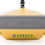
Topcon Positioning Group announced today at INTERGEO the latest addition to its HiPer series of integrated receivers — the HiPer VR is designed to provide a versatile solution with the most advanced GNSS technology available.
“The HiPer VR is packed with the most powerful GNSS technology in a housing built to withstand the harshest field environments,” said Alok Srivastava, director of GNSS Product Management. “The Topcon advanced GNSS chipset with Universal Tracking Channels™ technology allows the HiPer VR to automatically track signals from all available constellations — including GPS, GLONASS, Galileo, BeiDou, IRNSS (NavIC), QZSS, SBAS — now and into the future.”
By Inside GNSS
If you are interested in innovative products and services in the GEOSPATIAL sector, then you should consider attending INTERGEO October 16-18 in Frankfurt, Germany.
By Inside GNSS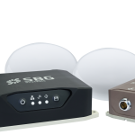
At this week’s INTERGEO show in Frankfurt, Germany, SBG Systems released the Navsight Land/Air Solution, a full high performance inertial navigation solution designed to make surveyors’ mobile data collection easier, whether it is mobile mapping, GIS, or road inspection.
Navsight Land/Air Solution consists of an Inertial Measurement Unit (IMU) available at two different performance levels, and connected to Navsight, a rugged equipment embedding the fusion intelligence, the GNSS receiver, and all connections to external equipment such as LiDAR, cameras, computer, etc.
By Inside GNSS