GPS + inertial + camera + LiDAR + baro-altimeter = a very precise measurement, right? Not when the respective sensor output timings lack proper synchronization. Only when each piece of data carries an accurate timetag can they together enable optimal performance in multi-sensor fusion systems.
Trimble has introduced two new GNSS smart antennas, the AX940 and AX940i, designed for a broad range of high-precision applications such as precision agriculture, milling machines in construction, forestry harvesting equipment, autonomous vehicles, port automation and mobile mapping.
The MEMS-based inertial measurement unit (IMU) represents the single biggest positioning and navigation advance of the last 20 years. That assertion is made during the first of three panels in the webinar “Inertial Technology for Robotics, UAVs and other Applications,” freely available on May 6. The 1.5 hour presentation examines how this breakthrough plays in the fields of autonomy, high dynamics and challenging environments, including on the frontiers of space.
Three experts takes a close-up look at contemporary and emerging inertial sensor technologies and applications, from the laboratory to the factory to the field. Register here to attend. The webinar is sponsored by Sensonor.
MEMS (micro-electromechanical sensors) make possible a miniaturization of size, weight, power requirements and cost never thought achievable before. When MEMS inertial navigation pairs with GPS for navigation, the key factor is the error budget of each sensor and how that plays into the accuracy of the solution. Attendees will learn how the new inertial sensors’ reduced error budgets translate into higher system performance.
The presentation begins with the current state of the inertial art, delivered by a recognized expert. The second speaker describes a high-accuracy tactical-grade inertial measurement unit (IMU) with increased accelerometer performance to support demanding guidance and navigation applications.
This knowledge is taken to the field to examine the IMU’s role in successful satellite launch missions during the third panel. The attitude determination and control system (ADCS) rises to the challenge of an extremely demanding environments and set of requirements. A satellite moving at a speed of 7,500 meters/second over ground requires precise maneuvering, stabilization and point in order to obtain imagery at 1-meter resolution.
Questions from the audience are actively encouraged and will be addressed by the three speakers in the final portion of the webinar.
Webinar speakers:
Ralph Hopkins, Draper Lab
Ralph Hopkins is a Distinguished Member of the Technical Staff and Group Leader in the Positioning Navigation and Timing (PNT) Division at Draper, a leading research & development organization. He is responsible for the design and development of inertial instruments and sensors. Ralph has served as Technical Director of advanced inertial instrument development programs including strategic, navigation and tactical grade gyroscopes and accelerometers. He holds an ME in Engineering Mechanics from Columbia University, and an MS in Engineering Management from The Gordon Institute of Tufts University.
Reidar Holm, Sensonor
Reidar Holm is a Product Development Manager at Sensonor, a producer and developer of high-precision, light-weight gyros and IMUs. He works MEMS R&D and design, ASIC design, low-stress package design, system design, assembly and calibration, and high-volume production for automotive, MEMS pressure sensors, accelerometers, gyros and IMUs. He has a Degree in Electrical Engineering and Electronics from University of Manchester Institute for Science and Technology (UK) in 1982.
Ryan Robinson, LeoStella
Ryan Robinson is the Lead Guidance, Navigation and Control Engineer at LeoStella, a small satellite design and manufacturing company, He is responsible for the design, development, test, and delivery of ADCS subsystems on LeoStella satellites. He received a Ph.D. in Aerospace Engineering from the University of Maryland, College Park. Technical areas of interest include attitude determination and control systems design, sensing and actuation, nonlinear dynamics, and autonomy.
Register here for the free webinar, “Inertial Technology for Robotics, UAVs and other Applications.” The webinar will also be available for subsequent download, for those registrants unable to attend at the appointed time.
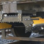
LORD Corporation, a global provider in sensing systems, has partnered with Emesent, an award-winning company in autonomous technology for industrial drones, to bring industry-leading inertial sensors to the Hovermap platform. Hovermap automates the collection and analysis of data in challenging GPS-denied environments, reportedly delivering revolutionary efficiency, safety and operational insights to various industries, including the underground industry. LORD inertial sensors enable Hovermap technology by providing precise position, orientation and velocity information in a small and lightweight package.
ACEINNA has launched its new INS1000 high performance dual-band RTK INS (Real-Time Kinematic Inertial Navigation System) with built-in inertial sensors for construction, agriculture and automotive applications.
The INS1000 embeds ACEINNA’s 9 degree-of-freedom inertial sensor technology to achieve Automotive Dead Reckoning performance in GNSS challenged environments like urban canyons, heavily tree-lined roads, tunnels, underpasses, bridges, etc.