August 23, 2018
Septentrio Launches the AsteRx-i S GNSS/INS Solution
GNSS receiver manufacturer Septentrio announces today the addition of the AsteRx-i S to its GNSS/INS product portfolio.
By Inside GNSSGlobal Navigation Satellite Systems Engineering, Policy, and Design
GNSS receiver manufacturer Septentrio announces today the addition of the AsteRx-i S to its GNSS/INS product portfolio.
By Inside GNSS
u-blox recently announced the ZED-F9P multi-band GNSS module with integrated multi-band real-time kinematics (RTK) technology for machine control, ground robotic vehicles, and high precision unmanned aerial vehicles (UAV) applications. The ZED‑F9P measures just 22 x 17 x 2.4 millimeters and uses technology from the recently announced u‑blox F9 platform to deliver robust high-precision positioning performance in seconds, according to the company.
By Inside GNSS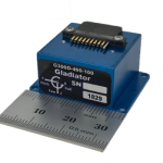
Gladiator Technologies has introduced a three-axis, inertial rate system, the G300D gyro. With small size, low power and high speed, the G300D gyro is particularly well-suited for image stabilization applications.
By Inside GNSS
NovAtel Inc. today launched its new TerraStar-C PRO correction service with multi-constellation support, including the GPS, GLONASS, Galileo and BeiDou constellations. Combined with NovAtel’s OEM7 positioning technology, TerraStar-C PRO cuts initial convergence times by nearly 60 percent and offers 40 percent better horizontal accuracy than the current TerraStar-C service.
By Inside GNSSThe Galileo constellation took another big step towards full operational capability with the successful launch last month of four satellites on-board an Ariane 5 launcher. Representatives of leading industry that have adopted Galileo then held a special press briefing for journalists from across the continent to address updates on how European citizens and businesses are already taking advantage of benefits delivered by Galileo.
By Stan Goff
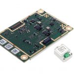
GNSS receiver manufacturer Septentrio recently launched the next generation AsteRx-i which combines the company’s latest compact, multi-frequency multi-constellation GNSS engine with an external industrial grade MEMS based IMU. It can deliver accurate and reliable GNSS/IMU integrated positioning to the cm-level as well as full 3D attitude at high update rates and low latency, according to Septentrio.
By Inside GNSS
The United States Geospatial Intelligence Foundation (USGIF) is excited to announce the addition of Al Di Leonardo and Patty Mims to the Foundation’s Board of Directors. USGIF’s Board includes 26 directors representing the many aspects of the broad and expanding GEOINT Community.
Di Leonardo is an experienced intelligence and special operations officer and is widely recognized as a subject matter expert in analytical tradecraft, and Mims is currently director of Global National Government at USGIF Organizational Member Esri.
“I am pleased that professionals of this experience and caliber are part of the USGIF leadership,” said The Honorable Jeffrey K. Harris, Chairman of USGIF’s Board of Directors.
Di Leonardo has more than 25 years of government experience centered at the National Security Agency, the National Geospatial-Intelligence Agency, and Joint Special Operations Command. As a career U.S. Army Intelligence Officer, he earned the Bronze Star Medal from U.S. Special Operations Command (SOCOM) for his work in Afghanistan and Iraq and led SOCOM’s first geospatial big data innovation cell. After retiring from the Army, Di Leonardo founded HumanGeo, a tech company that created software solutions at the intersection of big data, social media, and geospatial intelligence that he later sold to The Radiant Group. As president of The Radiant Group, he led the integration of five companies while simultaneously rebranding the team as “Radiant” and significantly growing revenue, leading to Radiant’s acquisition by DigitalGlobe.
“Al brings rich operational and analytic experience across important market sectors to the USGIF boardroom,” Harris said. “His understanding of both mission and business effectiveness will be invaluable to help drive the USGIF working groups and technical forums.”
In her current role at Esri, Mims oversees all business development across the U.S. federal government, including intelligence, defense, public safety, and civilian as well as provides support to nonprofit programs globally and national government organizations around the world. Mims was Esri’s Director of Intelligence Programs from 2012 to 2015, and in this role managed all activities across the U.S. Intelligence Community and State Department. She has also held positions at Esri as team lead for the company’s Defense Installation Team and account lead for the Defense and Intelligence Team. Prior to joining Esri, Mims worked for an international software company where she supported customers around the world as manager of Technical Support and Training.
“Patty operates at the intersection of commercial and defense and intelligence geographic information systems,” Harris said. “Her market understanding and technical expertise will add great value to the Foundation as we help build improved tradecraft.”
By Inside GNSS
GMV, Tecnobit and Skydel announced last week that they are working to adapt Skydel’s Global Navigation Satellite System (GNSS) simulation solution to support the latest developments of the Galileo GNSS, synchronizing with the European efforts to bring a modern, highly-accurate and secure positioning system to the market. GMV, Tecnobit, and Skydel aim to provide corporations, universities, and research labs with a reliable, advanced simulation system that closely follows the latest Galileo capabilities.
By Inside GNSS
Global Invacom, a global provider of satellite communications equipment, is pleased to announce the launch of an innovative solution enabling aircraft ground engineers to undertake 24/7 avionics testing of Inmarsat, Iridium and GPS satellite signals indoors.
By Inside GNSS
Harris Corporation has been awarded three multi-award IDIQ contracts with ceilings totaling $1.5 billion to provide the National Geospatial-Intelligence Agency (NGA) with geospatial data services for up to 10 years.
Harris will create, manage and disseminate high-quality geospatial-intelligence (GEOINT) information for use by the U.S. intelligence community and military worldwide under contracts that cover all three areas of NGA’s JANUS program – geography, imagery and elevation.
By Inside GNSSNovAtel announced today that it is now delivering their market-leading SPAN® tightly-coupled GNSS+INS navigation technology in a rugged, ultra-compact unit. Commercially exportable and ideal for integration into a wide variety of applications, the high-performance SPAN CPT7 is designed to deliver assured positioning – anywhere, in a package one-quarter the size of the highly successful SPAN-CPT.
By Inside GNSS
Curtiss-Wright’s Defense Solutions division announced that it will highlight its family of commercial-off-the-shelf (COTS)-based modules and LRU solutions designed for system integrators seeking to rapidly and cost-effectively deploy Assured Position, Navigation and Timing (A-PNT) services at the 2018 Joint Navigation Conference, July 9-11 (Booth #109), the largest U.S. military Positioning, Navigation and Timing (PNT) conference of the year with joint service and government participation.
By Inside GNSS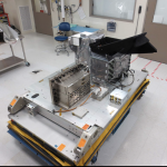
Harris Corporation has delivered an environmental monitoring sensor for the Greenhouse Gases Observing Satellite-2 (GOSAT-2), which will significantly enhance Japan’s ability to monitor greenhouse gases from space.
The Harris-built TANSO-FTS-2 (Thermal and Near Infrared Sensor for Carbon Observation-Fourier Transform Spectrometer-2) will measure greenhouse gases in the atmosphere. The newly built instrument will collect high-spectral resolution data of the Earth in five bands, which enables measurement during daylight and darkness. The instrument’s unique intelligent pointing system identifies, in real time, cloud-free areas of the atmosphere – greatly increasing the amount of useable data, according to the company.
By Inside GNSS
Atos recently announced the launch of ProUST univerSAS (Protection Unit for Satellite Testing), its lightweight, compact satellite power testing system designed to improve high-volume satellite production by increasing the speed and efficiency of testing, while maintaining the industry’s quality and safety standards.
ProUST univerSAS is the first product following Atos’ recent acquisition of Siemens Convergence Creators (CVC), resulting in reinforced capabilities in the space market. The product is the latest addition toAtos’ integrated suite of electrical satellite testing solutions – EGSE (Electrical Ground Support Equipment) – which ensures that satellites’ systems are in optimum condition in order to work flawlessly during their entire lifespan in-orbit.
The ProUST univerSAS is a compact and power-dense satellite power testing system, said to delivermore than 16kW of power in just 2HU (~10cm). It is unique in that it can test numerous power configurations (Solar Array Simulation, Battery Simulation and Load Simulation) in one single device.
New Space challenges require a new kind of equipment
This system supports manufacturers to meet today’s ambitious high-volume production loads and adapt from traditional, mostly manual assembly, towards a more efficient manufacturing process. Its light weight, compact size, versatility and portability enables manufacturers to save on space and costs and improve on efficiency for faster development and testing cycles, using one single device.
“The introduction of ProUST univerSAS marks a new era in satellite power test system design. We are bringing together unprecedented power handling capability and versatility with assembly-line efficiency for the space industry. The system’s mobility facilitates flexible deployment in state-of-the-art production facilities around the globe, making it a natural building block of today’s and tomorrow’s satellite manufacturing installations,”Hans-Martin Steiner, CTO Space & Avionics at Atos, said in a press release.
Atos is experienced in providing effective solutions to the space industry, including those used in ground mission and control centers. It is also a pioneer in the development of Earth Observation Data exploitation platforms and is fostering innovation with numerous R&D projects.
By Inside GNSS
The Federal Aviation Administration’s Geosynchronous Earth Orbiting 5 Wide Area Augmentation System (WAAS) navigation payload, developed by Raytheon’s Intelligence, Information and Services business, is now operational and fully integrated into the WAAS network. The GEO 5 payload joins two others already on orbit in correcting GPS satellite signal ionospheric disturbances, timing issues, and minor orbit adjustments, giving users increased coverage, improved accuracy, and better reliability.
By Inside GNSS