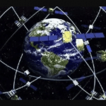
The China Satellite Navigation Office (CSNO) announced completion of two years of testing of BeiDou inter-satellite links, an innovative feature of the GNSS that will reportedly produce greater accuracy for users on Earth. The test campaign encompassed 29 satellites of the third generation (BDS-3) of the now global system.
Beijing’s municipal government released a three-year plan to promote the innovation and development of industries related to the BeiDou Navigation Satellite System. The total output of BeiDou navigation and location service industry in the Beijing region will exceed 100 billion yuan ($14.4 billion U.S. dollars) by 2022, according to the plan document.
According to a statement by the head of U.S. Air Force Air Combat Command, pilots of the elite U-2 spy plane wear watches that receive foreign GNSS signals and provide backup navigation when GPS is jammed.
“My U-2 guys fly with a watch now that ties into GPS, but also BeiDou and the Russian [GLONASS] system and the European [Galileo] system so that if somebody jams GPS, they still get the others,” said Gen. James “Mike” Holmes on March 4 at the McAleese Defense Programs Conference in Washington.
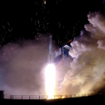
The Lockheed U-2, nicknamed “Dragon Lady,” is a single-jet engine, ultra-high altitude (70,000 feet, 21,300 meters) reconnaissance aircraft. It gathers intelligence with a variety of sensors. The U-2 is one of very few aircraft that have served the Air Force for more than 50 years, a select group that also includes the B-52 long-range bomber. The latest model, the U-2S, had a technical upgrade in 2012. [Dragon Lady photo above, courtesy Lockheed.]
Gen. Holmes did not name the watch manufacturer.
In February 2018, Garmin announced that its D2 Charlie aviator watch had been selected by the Air Force for use by the pilots of the Lockheed U-2 aircraft. “The high-sensitivity WAAS GPS-enabled D2 Charlie aviator watch incorporates global navigation capability, rich and colorful moving maps and more, providing pilots in the USAF with an exclusive, back-up navigation timepiece in the cockpit. . . . The D2 Charlie aviator watch will be an integral and functional part of the U-2 pilot’s toolkit.”
According to the press release, Garmin expected the United States Air Force to take delivery of more than 100 D2 Charlies.
Among the sensors mentioned on Garmin’s spec sheet for the watch are GPS, GLONASS, a heart rate monitor, barometric altimeter, compass, accelerometer and thermometer. BeiDou is not listed.
However, in an annual report filed with the Securities and Exchange Commission, the company stated: “Garmin utilizes a variety of other global navigation satellite systems (GNSS) including, but not limited to . . . .The BeiDou Navigation Satellite System (BDS), a Chinese satellite navigation system that is expected to have 35 operating satellites in orbit by 2020 and will provide global coverage.”
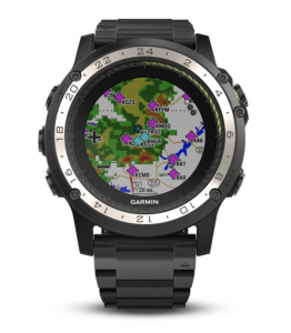
Garmin’s D2 Charlie watch, shown here with Weather radar overlay feature. Photo: Garmin
D2 Charlie has a sapphire scratch-resistant crystal lens and a diamond-like carbon (DLC) coated titanium bezel. A sunlight-readable, high-resolution color display with LED backlight on the watch face allows pilots to view data in most lighting conditions in the cockpit. It offers up to 20 hours of battery life in GPS mode and up to 12 days in smartwatch mode. It comes with a leather wristband and a sporty silicone band.
In lead position on a sleigh rising from the North Pole to a height of 200 meters — standard cruising altitude for global package delivery — at 2100 hours UTC on December 24 — the youngest will hopefully be asleep by then and there’s plenty of territory to cover before dawn breaks, time’s a-wasting — navigator Rudolph will see between 40 and 45 GNSS satellites glistening in the night sky.
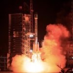
China threw two BeiDou satellites into space on Dec. 16. According to Yang Changfeng, BeiDou constellation chief designer, this brings to 24 the total of medium-Earth orbit (MEO) BDS-3 satellites in orbit, bringing completion to the core system. China has stated its mission to complete the BDS-3 constellation by 2020.
Key officials from the BeiDou and GLONASS programs, affiliated organizations and members of the satellite navigation industry met at the end of August to fine-tune a cooperation deal between the two systems.
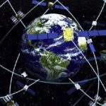
The Chinese are closing in on the completion of the BeiDou constellation with 39 satellites now on-orbit and more launches planned, an official told a conference on aerospace technology innovation.
Yang Jun, deputy director of China’s Satellite Navigation System Management Office, told attendees at the Shanghai event that the plan is to loft five to seven more satellites into place this year and another two to four in 2020, according to the Xinhua news agency.
China’s Xi’an Satellite Control Center recently completed a health check of more than 10 BeiDou-2 navigation satellites using a data system that slashed the analysis time from 10 hours to five minutes.
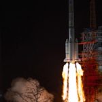
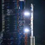
Launched on a Long March-3B carrier rocket, China sent a new satellite of the BeiDou Navigation Satellite System (BDS) into space from the Xichang Satellite Launch Center in Sichuan Province at 2:09 a.m. Tuesday, June 25, according to the Chinese news agency Xinhua.
UPDATE:A week after this story appeared the news broke that Fred Kennedy had quit as the head of the Air Force’s new Space Development Agency after just four months on the job. News reports suggested that issues with his boss, Undersecretary of Defense for Research and Engineering Mike Griffin, were at the heart of the resignation. — Dee Ann Divis
The director of the Department of Defense’s new Space Development Agency (SDA) said Friday that one of his priority projects is to create an alternate GPS capability using frequencies different from those of the current constellation.
China’s stated goal is to have its BeiDou global navigation satellite system completed sometime in 2020, and the country made big advances toward that goal last weekend when it launched a 20th satellite late on Saturday.
The China Satellite Navigation Conference (CSNC) is an open academic platform for academic exchanges that aims at enhancing academic innovation to promote cooperation and exchanges in the field of satellite navigation. The event, which opens May 22, also is designed at strengthening technological innovation to accelerate engineering construction of satellite navigation systems, intensifying theoretical innovation to facilitate theory progress of satellite navigation and reinforcing application innovation to boost development of the satellite navigation industry.
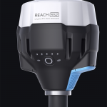
Designed for surveying, mapping and navigation, the new REACH RS2 RTK GNSS receiver from Emlid comes with a mobile app.
Reach RS2 gets a fixed solution in just seconds and maintains robust performance even in challenging conditions, according to the manufacturer. Centimeter accuracy can be achieved on distances over 60 kilometers in RTK, and 100 kilometers in PPK mode.