September 22, 2022
Raytheon Intelligence & Space Awarded Contract to Update FAA’s WAAS
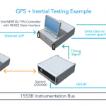
The FAA recently awarded Raytheon Intelligence & Space (RI&S), a Raytheon Technologies business, with a contract to modernize the Wide-Area Augmentation System (WAAS), providing a technical refresh and Dual Frequency Operation (DFO) upgrades to the space-based precision navigation system.
By Inside GNSS