
December 24, 2021
First Responders Gain Valuable Insights from Applanix Technology for Rescue and Damage Assessment
Georeferenced aerial images and mapping captured by NOAA with sixth-generation Digital Sensor System
By Inside GNSSGlobal Navigation Satellite Systems Engineering, Policy, and Design
Georeferenced aerial images and mapping captured by NOAA with sixth-generation Digital Sensor System
By Inside GNSS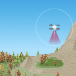
Keeping a mapping drone at a safe distance from rugged vertical terrain during its mission requires intense planning and a GNSS-enabled technology called “terrain following.” A new online video series and free webinar document the real-life challenges and hazards that professional surveyors encounter in their work, this among them.
By Inside GNSS
Registration is now open for this Free Webinar on Tuesday, April 16, 2019 from 1:00 PM – 2:30 PM ET. This event is sponsored by Inside Unmanned Systems, Applanix and Trimble. Note: This webinar has taken place and soon will be available on-demand.
By Inside GNSS
Applanix, a Trimble company, invites you to its 2018 Airborne User Group Meeting in Barcelona, Spain, Nov. 27-29, 2018.
By Inside GNSSApplanix, a Trimble Company, and AXIS-GPS recently announced that AXIS-GPS has been selected to provide Applanix’ products, support, and service to air and land clients in Israel.
By Inside GNSS