 One of 12 magnetograms recorded at Greenwich Observatory during the Great Geomagnetic Storm of 1859
 1996 soccer game in the Midwest, (Rick Dikeman image)
 Nouméa ground station after the flood
 A pencil and a coffee cup show the size of NASA’s teeny tiny PhoneSat
 Bonus Hotspot: Naro Tartaruga AUV
 Pacific lamprey spawning (photo by Jeremy Monroe, Fresh Waters Illustrated)
 “Return of the Bucentaurn to the Molo on Ascension Day”, by (Giovanni Antonio Canal) Canaletto
 The U.S. Naval Observatory Alternate Master Clock at 2nd Space Operations Squadron, Schriever AFB in Colorado. This photo was taken in January, 2006 during the addition of a leap second. The USNO master clocks control GPS timing. They are accurate to within one second every 20 million years (Satellites are so picky! Humans, on the other hand, just want to know if we’re too late for lunch) USAF photo by A1C Jason Ridder.
  Detail of Compass/ BeiDou2 system diagram
 Hotspot 6: Beluga A300 600ST

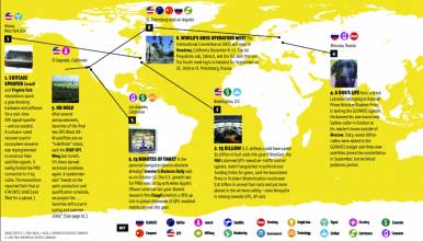
Electronic Throwaways, Space X Wins, Drones at Sea and Shaking It Up
Electronic Throwaways, Space X Wins, Drones at Sea and Shaking It Up
1. THROWAWAYS
Seattle, Washington and Hong Kong, China
√ Where does America’s electronic waste end up? A Seattle watchdog group and the MIT Senseable City Lab found out. Basel Action Network placed 200 GPS tracking devices on old computers, phones, and printers and dropped them at reputable recycling and donation centers in Washington and Oregon. About 1/3 was smuggled as far as 12,000 miles overseas, and much of that landed in Hong Kong’s New Territories. There, the e-waste — and the mercury, dioxin, and lead inside it — are burned, parted out, and ground into dust. “The electronic recycling business is like the wild west,” one scrap metal dealer told the Public Broadcasting System.
- (May 10, 2016) PBS.org: Where does America’s e-waste end up? GPS tracker tells all
2. SPACE X WINS
Hawthorne (Los Angeles), California
√ A GPS III satellite will fly on Space X Falcon 9 rockets. The firm, fixed-price, stand-alone contract for $82.7 million covers launch vehicle production, mission integration, launch ops and spaceflight certification, for the planned flight of the new SV in May 2018. Space X sent their bid over the transom (unsolicited) and longtime contractor United Launch Alliance dropped out of competition saying, among other things, they didn’t think they could compete on cost. See the Industry View article for more details.
3. DRONES AT SEA
Portland, Oregon
√ DARPA introduced its new robotic anti-submarine twin-screw trimaran in April. Built in Portland, Sea Hunter will be tested for a couple of years in San Diego before going into active Naval service. It can sail the ocean for thousands of miles and many months with no onboard crew (but remote human overseers for now). Known officially as Anti-Submarine Warfare Continuous Trail Unmanned Vessel (ACTUV) the autonomous warship takes human perception into consideration in its collision avoidance system — it changes direction as well as reduces speed so that observers on other ships can see what it’s doing. It uses the IMO’s mandated Automatic Identification System and obeys all the rules of the road at sea.
4. MYSHAKE
Berkeley, California
√ The UC Berkeley Seismological Lab wants you and your smartphone to help build a worldwide dataset that will help predict and mitigate earthquake effects — especially in areas with inadequate seismic ground networks. Their proof-of-concept app, MyShake, uses the accelerometers and GPS in phones to recognize tremblors and send the (anonymous) information back to the lab. It runs in the background and uses very little power. Next step? Send alerts to the smartphone so that you have a few seconds to take cover. Free here.
- (February 12, 2016) Science Advances: MyShake: A smartphone seismic network for earthquake early warning and beyond
Hotspots apologizes for dominating this edition with news of its own home region – the U.S. Pacific Coast – but what can you do? It’s an interesting place.


