 One of 12 magnetograms recorded at Greenwich Observatory during the Great Geomagnetic Storm of 1859
 1996 soccer game in the Midwest, (Rick Dikeman image)
 Nouméa ground station after the flood
 A pencil and a coffee cup show the size of NASA’s teeny tiny PhoneSat
 Bonus Hotspot: Naro Tartaruga AUV
 Pacific lamprey spawning (photo by Jeremy Monroe, Fresh Waters Illustrated)
 “Return of the Bucentaurn to the Molo on Ascension Day”, by (Giovanni Antonio Canal) Canaletto
 The U.S. Naval Observatory Alternate Master Clock at 2nd Space Operations Squadron, Schriever AFB in Colorado. This photo was taken in January, 2006 during the addition of a leap second. The USNO master clocks control GPS timing. They are accurate to within one second every 20 million years (Satellites are so picky! Humans, on the other hand, just want to know if we’re too late for lunch) USAF photo by A1C Jason Ridder.
  Detail of Compass/ BeiDou2 system diagram
 Hotspot 6: Beluga A300 600ST

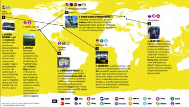
1. ASHES & AIRPLANES
Boulder, Colorado USA
1. ASHES & AIRPLANES
Boulder, Colorado USA
√ Someday, aircraft electronics could analyze GNSS signal strength as it becomes blocked by volcanic ash and detect it early enough to avoid clogging the engines. In Geophysical Research Letters, University of Colorado aerospace engineer Kristine Larson realizes the value of this often unused data. With monitors on many volcanoes — and more signals arriving with multi-GNSS — this ubiquitous information might become a useful, inexpensive air safety tool.
- Geophysical Research Letters, June 13 2013: A new way to detect volcanic plumes
2. FIREBALL
Baikonur Spaceport, Kazakhstan
√ Three Glonass satellites disintegrated when their Proton-M rocket blew up seconds after launch on July 2. The failure caused indefinite suspension of scheduled Proton launches from Baikonur. Russian Deputy Prime Minister Dmitri Rogozin leads an investigating commission and expects to report by the end of July — including a list of responsible officials. RIA Novosti cited a premature launch and Interfax-AVN reported that angular velocity sensors had been installed upside down.
- Inside GNSS, July 6 2013: Premature Launch May Have Doomed GLONASS Satellites
- RIA Novosti, July 2, 2013: Russian Rocket Crashes Seconds After Launch, Toxic Fuel Alight
- RIA Novosti, July 18, 2013: Proton-M Rocket Downed by Reversed Sensors – Roscosmos
3. BEIDOU AND BAIXING
Shanghai, China
√ China wants regular folks (“Baixing”) to get to know BeiDou, but the user segment is too underdeveloped for consumers to create the demand. So Shanghai intends to spend US$30.65 million in the next 18 months to build BeiDou compatible ground-based infrastructure, a Wi-Fi network and 50,000 receivers for elder and child monitoring, tourism and transport, and more. The goal: spark the commercial market and get everyone on board.
- Xinhua, June 22 2013: Beidou’s 2nd Trial held in Yangtze Valley
- Newspaper Shanghai, June 21 2013: Compass application demonstration project to start
- Global Times, June 23 2013: Beidou pilot program to help the aged
4. ERROR ALERT
Canberra, Australia
√ More than a decade of supersized earthquakes greater than 8.0 have frazzled GPS ground monitoring stations all over the world. Nearly every ground site has shifted since 2000, at an average rate of 0.4 millimeters per year, said Australia National University geoscientist Paul Tregoning. The terrestrial reference frame shifts will cause GPS measurement errors and throw off calculations of orbits. “We’ll have to find a way to deal with it” he said.
- Live Science, May 23 2013: Big Earthquakes Create Global-Scale GPS Errors
- Journal of Geophysical Research: Solid Earth, May 6 2013: A decade of horizontal deformation from great earthquakes
5. FLOODED OUT
Nouméa, New Caledonia
√ The heaviest rains and floods in 60 years washed out the access road to one of Galileo’s most remote ground stations in July, marooning the crew for 40 hours until their access road was repaired. Built on the flats surrounded by hills, the Nouméa station was designed to screen unwanted radio signals. Those same characteristics made it a rain funnel. Thanks to high foundations and an emergency generator, everything kept on ticking.
- ESA, July 15 2013: South Pacific Galileo station endures freak rains and flood


