Environment Archives - Page 13 of 14 - Inside GNSS - Global Navigation Satellite Systems Engineering, Policy, and Design

Environment

April 25, 2009

GNSS Hotspots | April 2009

One of 12 magnetograms recorded at Greenwich Observatory during the Great Geomagnetic Storm of 1859
1996 soccer game in the Midwest, (Rick Dikeman image)
Nouméa ground station after the flood
A pencil and a coffee cup show the size of NASA’s teeny tiny PhoneSat
Bonus Hotspot: Naro Tartaruga AUV
Pacific lamprey spawning (photo by Jeremy Monroe, Fresh Waters Illustrated)
“Return of the Bucentaurn to the Molo on Ascension Day”, by (Giovanni Antonio Canal) Canaletto
The U.S. Naval Observatory Alternate Master Clock at 2nd Space Operations Squadron, Schriever AFB in Colorado. This photo was taken in January, 2006 during the addition of a leap second. The USNO master clocks control GPS timing. They are accurate to within one second every 20 million years (Satellites are so picky! Humans, on the other hand, just want to know if we’re too late for lunch) USAF photo by A1C Jason Ridder.
Detail of Compass/ BeiDou2 system diagram
Hotspot 6: Beluga A300 600ST

1. LAYING DOWN THE LAW
Albany, New York;
Madison, Wisconsin
√ In May, the New York Court of Appeals ruled 4 to 3 that warrantless GPS surveillance isn’t legal. Oregon and Washington courts agree. Meanwhile, a Wisconsin appeals court panel ok’d secret police use of a GPS tracking device, because it didn’t involve search or seizure. Wonder when the Feds will chime in…

2. BACKUP
Washington, DC
√ The land-based radio navigation system, Loran-C and its eLoran modernization, has been cut from the 2010 federal budget. Key members of the Senate’s Homeland Security and Science and Transportation committees —  worried about the GAO’s report on a faltering GPS — question killing an interoperable but independent PNT backup.

3. GNSS FOR AFRICA
Trieste, Italy
50 scientists from 15 sub-Saharan universities consulted with GNSS experts — and even built LEGO Mindstorm robots — at the first Satellite Navigation and Technology for Africa workshop in April. Why? GNSS infrastructure means better maps, safer transportation, managed natural resources and food supplies, improved emergency services — major goals on the continent.

4. PAY TO PLAY
Moscow, Russia
√ The head of Roscosmos, Russia’s space agency, has asked the government to make it prohibitively expensive to import cars that can’t use GLONASS. Business newspaper Vedomosti said not many Russian cars have built-in navigation systems now, and only 10,000 of nearly two million imports can use the Russian GNSS.

5. READY TO GO?
Thiruvananthapuram, India
√ In just three years, says the director of the Vikram Sarabhai Space Centre (VSSC), India’s Regional Navigation Satellite System (IRNSS) will be up and running, delivering 10 meter accuracy to the subcontinent using three GEOs and four IGSO satellites. Could be the precursor to a full-fledged Indian GNSS.

6. L5: A MIXED BAG
Middle Earth Orbit
√ The GPS satellite carrying the new “safety-of-life” civil signal is under investigation. An L5 signal transmitted on April 10 was healthy. But signals on the L1 frequency are not meeting spec. Larger than expected pseudorange errors, says the GPS Wing’s chief engineer. The L5 signal itself could be a cause.

By Alan Cameron
[uam_ad id="183541"]
April 15, 2009

About GLONASS

GLONASS is the Russian Federation’s GNSS—literally. The Russian acronym stands for GLObal’naya NAvigatsionnaya Sputnikovaya Sistema, or Global Navigation Satellite System.

Chronologically the world’s second GNSS system, both the program (established in 1976) and the first launch of a GLONASS satellite (October 12, 1982) followed the corresponding United States GPS milestones by a few years.

Read More >

By Inside GNSS
February 24, 2009

March-April 2009 Editorial Preview

To advertise, contact glen@insidegnss.com

Ad closing date: March 9

Ad materials due: March 16
Look for the March-April issue at 2009 CTIA Wireless, Las Vegas, Nevada (March 31-April 4) and the International Conference on Integrated Navigation Systems, St. Petersburg, Russia (May 25-May 27)

Read More >

By Inside GNSS
January 8, 2009

AUVSI Unmanned Systems Program Review 2009

AUVSI sponsors a three-day review of government unmanned system programs at the Mandarin Oriental Hotel in Washington DC on February 3-5 2009.

The event features 30 sessions covering air, ground and maritime systems. Topics include Next Generation UAS, Civil Use of UAS, DARPA Programs, NIST Search and Rescue, Irregular Warfare use for Maritime Systems, and many more.

AUVSI is the Association for Unmanned Vehicle Systems International, an industry group.

Register online at the website below.

Read More >

By Inside GNSS
[uam_ad id="183541"]
August 11, 2008

Europe Launches Full Galileo Procurement

The European Commission (EC) — with the support of the European Space Agency (ESA) — has launched the procurement process for Galileo with an invitation to companies to submit requests for participation as prime contractors for six work packages (WPs) valued at €2.145 billion (US$3.39 billion).

The deadline for replying to the invitation is August 7.

In a resolution on space and security passed by a large margin on July 10, the European Parliament endorsed the use of Galileo, particularly the public regulated service or PRS, as necessary for autonomous operations under the European Security and Defense Policy — perhaps the most forthright statement of support for prospective use of the civil-controlled GNSS system for military purposes.

In the meantime, Galileo program scientists and independent researchers continue to track and test the signals being transmitted by the latest Galileo experimental satellite, GIOVE-B. Articles in the forthcoming September/October issue of Inside GNSS will discuss the latest results of in-orbit tests of GIOVE-A and –B, drawing in part on data collected using a 25-meter dish antenna at Chilbolton in the United Kingdom.

Two Delft University of Technology faculty members, Christian Tiberius and Hans van der Marel, working with engineers at Belgian GNSS receiver manufacturer Septentrio, have reported successful calculation of Galileo-only double-difference carrier phase integer ambiguity measurements using L1 Open Service signals from the two GIOVE spacecraft. That work will also be described in an article in the September/October issue [of Inside GNSS magazine].

ESA will act as the Galileo procurement and design agent for the EC, which is the program manager and contracting authority of the publicly financed project. The process will follow a distinctively European process that includes a “competitive dialog” between ESA and the prospective prime contractors.

Under the current schedule, within seven weeks following the RTP deadline ESA will approve a short list of companies that will be invited to submit preliminary proposals on the work packages and take part in a dialog. After vetting during an intermediate dialog phase, selected companies will offer “refined proposals.”

The new procurement plan seems to relegate non-European companies to subcontract status. But some U.S. companies would like to be able to compete for the lead contracts for the Galileo satellites, for instance.

However, the tender guidelines limit prime contracts in the Galileo FOC procurement to “natural or legal persons established in one of the Member States of the European Union.” Moreover, subcontractors providing goods or services related to EU or national security must also be from the EU. In “exceptional circumstances,” ESA may authorize the use of non-EU subcontractors.

The competitive dialog phase is projected to take 15–30 weeks at the end of which successful companies will be invited to submit best and final offers (BAFOs) and supporting documentation. Contract awards would follow within three weeks, according to the current plan; however, the EC and ESA emphasize that the proposed timeline is “purely indicative” and may be shortened or lengthened.

Individually, the following estimated values have been earmarked for the six work packages:
• WP 1: System Support: €120 million
• WP2: Ground Mission Segment: €270 million
• WP 3: Ground Control Segment: €45 million
• WP 4: Space Segment (satellites): €840 million
• WP 5: Launch Services: €700 million
• WP 6: Operations €170 million

The overall program objective for Galileo is the deployment, by 2013, of a full operational capability (FOC) GNSS system comprising 30 satellites and ground facilities. The FOC Galileo system will provide five main services: Open Service, the Safety of Life Service, the Commercial Service, the Public Regulated Service (PRS), and the Search and Rescue Service.

Wanted: GNSS Advisor
. Earlier, the EC Directorate-General for Energy and Transport (DG-TREN) issued an invitation to tender (ITT) for an advisor on the European GNSS program.

With a one-year term renewable up to three times, the contract will be designed to provide a pool of experts and organizations for review and counsel on administrative, financial, strategic and technical matters.

By
July 6, 2008

GPS Southern Africa Conference and Exhibition

The GPS Southern Africa Conference and Exhibition – the first of its kind in Africa – takes place from 20 August to 22 August 2008 at the Indaba Hotel, Fourways, Johannesburg.

The conference will highlight the many new applications of GPS technology across the board and the penetration of GPS in transport, safety and security, mining, government, and mining.

Read More >

By Inside GNSS
July 1, 2008

ESA Opens Galileo Procurement: Let the Games Begin!

Giuseppe Viriglio, ESA’s Director of Telecommunication and Navigation. ESA photo, A. Le Floc’h

Today (July 1), the European Commission (EC) — with the support of the European Space Agency (ESA) — launched the procurement process for Galileo with an invitation to companies to submit requests for participation as prime contractors for six work packages (WPs) valued at €2.145 billion (US$3.39 billion).

Read More >

By Glen Gibbons
January 7, 2008

Hope beyond the Hype

A large body of research recognizes personal mobility as the primary future market for global navigation satellite systems in terms of the number of users and potential revenue. This expectation is especially strong for the upcoming European satellite navigation system Galileo, for which location-based service (LBS) applications have a prominent place in market research.

A large body of research recognizes personal mobility as the primary future market for global navigation satellite systems in terms of the number of users and potential revenue. This expectation is especially strong for the upcoming European satellite navigation system Galileo, for which location-based service (LBS) applications have a prominent place in market research.

However, the past decade has seen many GNSS manufacturers and would-be service providers disappointed by the persistent failure of a profitable LBS mass market to emerge and grow rapidly. With the notable exception of a few national markets, particularly in Asia, this failure to thrive has stemmed from a combination of technical, legal, business, and market conditions that have thwarted development of widespread consumer LBS applications.

Previous GNSS activities in the field of LBS have primarily succeeded in commercial and professional applications (such as vehicle tracking and fleet management or remote monitoring of former prisoners out on probation or parole) or for safety and security purposes, such as emergency services. These are applications for which requirements can more easily be pinned down and where revenue streams are easier to estimate and project.

Moreover, regulatory activities and legal mandates have stimulated some large-scale uptake of GNSS technology— such as the U.S. Federal Communications Commission’s E-911 mandate, which requires automatic location identification capability be made available to aid emergency callers using mobile phones.

Despite this slow start, the LBS mass market definitely holds the potential for providing substantial revenue streams. However, its development remains rather difficult to predict. This article will present some of the leading prospective consumer application markets for LBS, examine the leading causes of the still sporadic adoption of LBS in these mass markets, and describe efforts to mitigate the current technical limitations constraining the growth of consumer-driven LBS.

In particular, on this latter point we will consider assisted-GNSS (A-GNSS) technology that uses information — typically, satellite ephemerides and constellation almanac — provided through the communications network infrastructure. We also address the possibility of combining various non-satellite-based positioning technologies with GNSS to provide the quality of service needed to support large-scale development and adoption of LBSs.

. . .

The LBS market has the potential to provide huge benefits to consumers. However, LBS needs to overcome technical and market obstacles before it can achieve the growth rates long predicted by market analyses. The AGILE project seeks to overcome these limitations by defining market drivers for LBS applications and, as detailed in this paper, to mitigate current technical limitations by combining various positioning technologies that can provide the quality of service needed to enable LBS.

(For the rest of this story, please download the complete article using the PDF link above.)

By
January 3, 2008

Unmanned Air Vehicles

Once we tried to Google “UAV” and got more than two million citations on the Internet.

Try to find the definition of unmanned aerial vehicle (UAV) and you’ll uncover a welter of choices in the literature. So, let’s just say that a UAV is an aerial vehicle capable of sustained flight without the need for a human operator onboard.

Although unmanned aerial vehicles (UAVs) are mostly used in military applications nowadays, the UAVs can also perform such scientific, public safety, and commercial tasks as data and image acquisition of disaster areas, map building, communication relays, search and rescue, traffic surveillance, and so on.

A UAV can be remotely controlled, semi-autonomous, autonomous, or a combination of these, capable of performing as many tasks as you can imagine, including saving your life. Nowadays, UAVs perform a variety of tasks in both military and civil/commercial markets. Indeed, many different types of UAVs exist with different capabilities responding to different user needs.

The purpose of this column is to give the reader an overview of the large number of existing UAV systems and R&D projects as well as the practical challenges facing UAV designers and applications.

. . .

Conclusions

A surprising and seemingly vast number of different types of UAVs exist in the literature, with different capabilities responding to different user needs. We have reviewed the four main categories: MAV/Mini UAVs; Tactical UAVs; Strategic and special task UAVS. MAV/mini UAVs represent the smallest class of UAVs and are mostly used for civil applications. Strategic UAVs are the largest and mostly used in military applications. Although the tactical and strategic UAVs are the more used, in the meantime MAVs and Mini UAVs will become more practical and prevalent.

Different kinds of UAV platforms have different mission and applications. For instance, most research institute prefers rotary wing UAVs with vertical take off and landing capacities as test platforms for demonstrating their research subjects. International competitions such as the Aerial Robotic competition organized by AUVSI are very important, not only as a good way to promote and share research results but also to understand what is going on in the field of UAVs.

As we said before, it is unreasonable to know all the ins and outs of UAVs. That is why one can say: Once we tried to “Google” UAV, we are still Googling UAV,” and . . . we haven’t found the end yet!

(For the rest of this story, please download the complete article using the PDF link above.)

By
January 1, 2007

Rescue Mission: GPS Applications in an Airborne Maritime Surveillance System

Maritime search and rescue (SAR) operations do not fit the usual and customary operational modes for aircraft operations. Consequently, neither do their navigation and flight management system (FMS) requirements.

Maritime search and rescue (SAR) operations do not fit the usual and customary operational modes for aircraft operations. Consequently, neither do their navigation and flight management system (FMS) requirements.

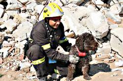
SAR missisions are not based on schedules but rather on ad hoc events and flights. Once the mission control center receives word of an accident (ship disaster, aircraft crash, etc.), an aircraft receives a mission order and begins a high-speed ferry flight to the area of concern. After arrival in the area of the incident, the aircraft typically performs a low-altitude (500 to 1,500 feet), low-speed search flight to locate survivors and the vessel.

In executing this search, the crew employs a suite of surveillance radars, electro-optical sensor, and scanning and direction finding equipment to localize  transmissions of emergency beacons that may have been activated during the accident. Once the target (person, ship, aircraft) is found, the crew drops needed equipment, such as life rafts or pumps, out of the aircraft.

The target position and other details are reported to the mission control center in order to initiate further rescue activities. All of these activities require precise navigation and sensor control, which may be obtained by a number of GNSS/GPS applications on board the aircraft.

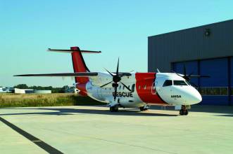
This article describes an airborne surveillance system, AeroMission, developed by Aerodata AG, and the GPS/inertial navigation system (INS) that supports its operation.

In addition to SAR missions, AeroMission is also suitable for maritime surveillance, border and anti-smuggling patrols, pollution detection and mapping, fishery control, offshore oil field monitoring, and research applications.

System Overview
AeroMission has been developed to provide high reliability, redundancy, and efficiency. It was designed using modular architecture and state of the art technology.

In supporting AeroMission, an integrated GPS/IMU navigation system — AeroNav — combines the GPS advantages of long-term stability and absolute accuracy with those of inertial navigation — short-term accuracy during phases of high dynamics in which GPS positioning may be lost or degraded.

A separate GPS/INS system also provides attitude reference by using strapdown algorithms providing position and velocity solutions. Turn rates and accelerations given by the IMU are corrected by the GPS pseudorange measurements. These corrections are calculated by a Kalman filter.

The basic system components include:
•    surveillance radar (using the separate GPS-supported INS)
•    forward-looking infrared (FLIR) sensor (using GPS services provided through AeroNav)
•    infrared/ultraviolet (IR/UV) scanner (using a dedicated GPS-supported INS)
•    Mission management and guidance system (using GPS services through AeroNav)
•    SAR Homing Device
•    HF, VHF, UHF, and satellite communication
•    Intercom including communication relay
•    Photo/video camera
•    Ergonomic operator work stations

Other sensors such as side-looking airborne radar or microwave radiometer can be integrated as options into the suite.

. . .

Sensor Suite
In addition to the navigation system, moving map display, system software, and databases, AeroMission incorporates a number of additional sensors to aid its surveillance and reporting functions.

  • Surveillance Radar . . .
  • Electro-optical/infrared sensor . . .
  • AIS and direction finding . . .

. . .

Mission Management
TheAeroMission management suite is an integrated solution that consists of equipment and software for sensor operation and control; sensor data gathering, storage, and evaluation; mission reporting, and communications control and recording.

. . .

Flight Deck Interface
The mission system has a number of interfaces to the flight deck in order to support the mission and decrease the work load of both the cabin crew and the flight deck crew.

. . .

System Qualification and Certification
The qualification and certification process for the project was quite challenging. All modifications of the airframe have been certified through a Supplemental Type Certificate (STC) approved by European Aviation Safety Agency.

. . .

Operational Experiences
During the test flights and also during the first 10 months of operations, AeroMission installed in a DO 328 aircraft has demonstrated its reliability and efficiency with an overall service availability of more than 99 percent . . .

For the complete story, including figures, graphs, and images, please download the PDF of the article, above.

By
IGM_e-news_subscribe