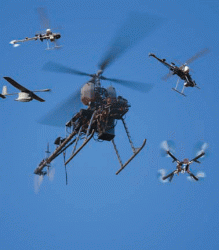
Significant progress has been made in integrating two classes of small, unmanned aircraft into the national air space (NAS), an area of considerable interest for GNSS companies whose products provide navigation and guidance for many of the unmanned systems.
Significant progress has been made in integrating two classes of small, unmanned aircraft into the national air space (NAS), an area of considerable interest for GNSS companies whose products provide navigation and guidance for many of the unmanned systems.
Standards have been drafted for the commercial use of unmanned aerial vehicles (UAVs) weighing up to 55 pounds, and the Federal Aviation Administration (FAA) and the U.S. Department of Justice (DoJ) have formally agreed to work together to help police departments and other government agencies quickly to make mini-drones — UAVs weighing less that 25 pounds — part of their operations.
Not yet clear, however, is what these developments will do for the overall market for unmanned systems. Government officials may decide to dial back purchases of unmanned aircraft if the privacy concerns sweeping the country trigger new limits on their use. Worries over privacy are already credited with slowing FAA’s integration efforts by months.
Although the standards are nearly complete, they need to be integrated into the FAA’s draft of its small UAV rule, which has yet to be finished. Once those are published for public comments, both will likely need to be updated at least once, probably twice, to incorporate the feedback.
The fact that the standards are nearly ready, however, is a bright spot for an industry deeply frustrated by delays on nearly every other front. The draft standards cover UAV design, including command and control systems and batteries. There are also standards for production, quality assurance, maintenance, and continued airworthiness as well as the aircraft flight manual and requirements for operations when flying over populated areas.
Setting Standards
Initial standards were developed by ASTM International, an organization formerly known as the American Society for Testing and Materials. The FAA chartered an Aviation Rulemaking Committee (ARC) in 2008 to examine the regulatory basis for permitting small unmanned aircraft systems (UAS) to operate for compensation or hire. ASTM was invited to participate and in 2010 signed a memorandum of agreement to develop the standards.
The standards were restructured over the last year to “better support both civil and public entities,” said Ted Wierzbanowski, in a paper for the Association for Unmanned Vehicles Systems International (AUVSI) conference in August in Washington, D.C. Wierzbanowski has led the standards effort as the chair of ASTM’s Committee F38. He said the draft standards are now being reviewed by the committee members and would soon be sent to the FAA for their consideration.
“What the FAA is planning to do is look at those standards and beta test them to see if they are too stringent or not stringent enough,” Wierzbanowski told Inside GNSS. Over the next couple of years the standards will be checked against existing hardware and weighed by developers working on new aircraft, with ample opportunity for public feedback, he said.
The standards will be used for civil drones once the small UAV rule takes effect — which could be several years from now.
Wierzbanowski said, “[F]rom what I understand, it is going to take quite a long time for [the FAA] to do what is called adjudicate, or resolve, all the comments they are gong to get from the general public. So most of us don’t think that this regulation for civil, again commercial, applications is going to be out for at least two, two and half, to three years.”
“It’s going to be a while,” he said.
While ASTM worked on standards for the smaller UAVs, another set of standards was being developed by RCTA committee SC-203 for larger, unmanned aircraft — an effort that is not nearly as far along. The task proved so large, experts said, that SC-203 was sunsetted in May and its tasks restructured to focus on developing the minimum operational performance standards or MOPS for detect-and-avoid equipment.
The new committee — SC-228 Minimum Operational Performance Standards for Unmanned Aircraft Systems — is emphasizing the initial phase of standards development for civil UAS operating in Class A airspace under instrument flight rules. The work is expected to extend into at least 2016.
Although that seems like a lengthy wait, the FAA will not be finished with the integration process for quite a while. The FAA has a mid-term and long-term plan, said FAA spokesman Les Dorr, and is looking at eventually integrating unmanned aircraft into NextGen, the new air traffic control system. “That’s where we expect to reduce the dependency on individual approvals,” he said
Green Light for Government
Government agencies, however, won’t have to wait to get started. The deal signed by the FAA and DoJ goes a long way toward fulfilling a congressional mandate to speed the use of drones by police, firefighters, and other government users.
The memorandum of understanding (MOU) signed in March taps the skills of the National Institute of Justice (NIJ), the Justice Department’s research, development, and evaluation arm. The NIJ will prepare a technical bulletin for law enforcement and other public safety agencies on using UAVs and will work with FAA to development training information. The institute will also gather operational mission data to enable “lessons learned” assessments.
The FAA’s Unmanned Aerial Systems Integration Office will assess each law enforcement agency that applies for a certificate of authorization (COA) to operate an unmanned aircraft of up to 25 pounds. Each applicant will initially receive a COA for training and performance evaluation, said the FAA. Once they have “shown proficiency in flying their UAS,” they will receive an operational COA.
The agreement also sets limits on the ways unmanned craft are operated. UAV pilots have to meet the requirements for a second-class airman medical certificate and follow the same drug and alcohol rules as pilots. UAVs cannot be used for pursuit and can only be flown during the day.
Operators must be able to see the UAV at all times, keep it below 400 feet and not fly it over groups of people or heavily trafficked roads. There must be a separate observer at all times and observers are not allowed to set up in a ‘daisy chain’ type of line leading away from the control station.
Privacy Fight Continues
The small size and strict operating parameters for the government drones should ease the public’s concerns over privacy, said Mario Mairena, government relations manager for AUVSI, the largest trade group representing the unmanned systems industry.
“The impression out there right now . . . is that these systems are going to be doing surveillance 24/7, and that’s simply is not true,” Mairena told Inside GNSS. Most of the systems being considered for use by law enforcement weigh between five and seven pounds and, because of battery limits, he said, can only stay aloft for 15 to 90 minutes.
Although that may be the case for most of the small UAVs, technological advances are already blowing through such physical limits. Lockheed Martin is offering the Stalker, an electric UAV that can stay aloft for as long as 8 hours on a single charge and 48 hours with laser recharging from the ground. The aircraft weighs less than 25 pounds with its payload and would be inaudible above 400 feet, according to Lockheed’s website.
Concern may arise from technological advances or accidents such as one that occurred in August in Petersburg, Virginia, when a UAV taking aerial images of the city’s “Great Bull Run” fell into a crowd and slightly injured several people. State lawmakers are expected to continue their push for greater control over the use of unmanned vehicles.
Some 42 bills that AUVSI considered anti-UAS were introduced in recent sessions of state legislatures. Of those, eight passed, said Mairena, and “we’ve defeated 19.” Nine other bills are still “in play,” he said, and activity will resume on six more in 2014.
Entering the fray in August were the Aerospace States Association (ASA), the National Conference of State Legislatures, and the Council of State Governments, which worked together to develop guidelines on what legislators might want to consider when contemplating drone legislation.
At the top of their list was “requiring a warrant for government surveillance of an individual or their property where the individual is specifically targeted for surveillance in advance without their permission.” The trio of groups also suggested that states consider prohibiting the repurposing of data collected from warrantless UAV observations unless a warrant allows it.
Mairena took issue with the ASA recommendation and told Inside GNSS that the rules for getting warrants when using airplanes and helicopters were enough to cover UASs as well.
“A lot of the bills have been introduced under the guise of privacy, and we don’t agree with that assessment,” Mairena said. “What the bills are attempting to do is rewrite search warrant requirements to create a separate distinction between manned and unmanned assets. We firmly believe that the proponents of the legislation are trying to make a social legal premise that surveillance systems should be deemed illegal, regardless of positioning.”
AUVSI supports the guidelines issued by the International Association of Chiefs of Police, he said, which recommend that “where there are specific and articulable grounds to believe that the UA (unmanned aircraft) will collect evidence of criminal wrongdoing, and if the UA will intrude upon reasonable expectations of privacy, the (law enforcement) agency will secure a search warrant prior to conducting the flight.”
Splitting Legal Hairs
But when does one have a reasonable expectation of privacy? When are airplane and helicopter operators required to get a warrant?
The answer is not clear. In three cases where targeted aerial surveillance of a location was undertaken without a warrant the U.S. Supreme Court held that the areas observed — the inside of a building through a hole in the roof, the interior of the fenced yard of a home, and the grounds around a chemical plant — were public spaces when seen from the air and therefore not protected.
“In a series of cases that provide the closest analogy to UAVs, the Supreme Court addressed the use of manned aircraft to conduct domestic surveillance over residential and industrial areas. In each, the Court held that the fly-over at issue was not a search prohibited by the Fourth Amendment, as the areas surveilled were open to public view,” wrote Attorney Richard M. Thompson II in a Congressional Research Service (CRS) report prepared for Congress titled “Drones in Domestic Surveillance Operations: Fourth Amendment Implications and Legislative Responses.”
Indeed, the FBI cited the same three 1980s cases referenced in the CRS report — California v. Ciraolo, 476 U.S. 207 (1986); Dow Chemical v. United States, 476 U.S. 227 (1986) Florida v. Riley 488 U.S. 445 (1989) when it told Senator Rand Paul (R-Kentucky) that the Supreme Court had ruled that aerial surveillance was not a search under the Fourth Amendment. Therefore, the agency argues, such surveillance did not require a warrant because the areas observed were open to public view and citizens there had no reasonable expectation of privacy.
The courts have also found, however, that long-term surveillance does require a warrant, even if done from public space. After the decision on United States v. Jones, in which a GPS tracking device was used to monitor a suspect’s movements, the court agreed that a warrant was needed. Although the majority opinion cited the search as an intrusion when the device was attached to a vehicle, several other judges pointed to the technology itself — perhaps signaling a willingness to update the case law to keep up with technology.
“So, when you get back to ‘When is a warrant required or not?’ it really is . . . not a clear issue,” said Anne McKenna, an expert on surveillance with the Baltimore law firm of Silverman, Thompson, Slutkin, and White LLC, which advises the National Police Foundation on drone-related issues.
Legal experts and law enforcement officials, searching for guidelines, are interpreting limits from the circumstances of the three Supreme Court cases. In Florida v. Riley the court held that a flight made at 400 feet over a building where marijuana plants were visible with the naked eye was not a search. In California v. Ciraolo the plane was at 1,000 feet and the observations were made with the naked eye of the fenced area around a house. In Dow Chemical v. United States the pilot used a precise aerial mapping camera.
For surveillance with a helicopter or plane “you need a warrant, if you are flying below 400 feet and then you also need a warrant, no matter what your AGL (above ground level) is if you are using some kind of technological enhancement — for example a FLIR (forward-looking infrared),” said Steve Ingley, executive director of the Airborne Law Enforcement Association.
The guidelines, Ingley said, are based on rulings from both state and federal cases and the same rules apply to unmanned systems. “They fall under the same rules as manned aircraft unless the states and Congress change those laws.”
“If . . . we are talking about no enhanced technology, the court is saying that you can take pictures from four hundred feet and above and you’re not in that protected zone of a house under the Fourth Amendment. That’s where that aviation group is getting that rule of thumb,” said McKenna. The court did not say you need a warrant at 300 feet “but that is the implication,” he added.
“Part of the problem here is that we have law that is not clear about the use of surveillance technology.” Drone technology keeps advancing and simply taking a photograph is not what drones are going to be doing, said McKenna, “Biosurveillance now is really common on drones. They are doing air sensing. And there is good reason for that — legitimate, very helpful reasons. . . . Drones aren’t just going to be taking photographs, they are going to be doing a lot more than that.”
The American Civil Liberties Union says warrants should be required for police use in private space and at least a reasonable suspicion standard for surveillance in public spaces, said Allie Bohm, an ACLU advocacy and policy strategist. “We think if you have actually had a debate and put in place sufficient privacy protections for law enforcement use of drones, you’re actually going to find communities more receptive (to their use),” she said. “In our view privacy protections are going to be good for industry.”


