
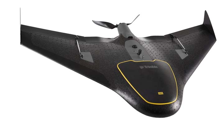
Trimble has introduced its next-generation unmanned aircraft system (UAS) — the UX5 aerial imaging rover with the Trimble Access aerial imaging application.
According to the Sunnyvale, California– based company, the new UAS enhances the image quality and workflows its predecessor, the Trimble Gatewing X100. Combined with the Trimble Business Center photogrammetry office software module, the Trimble UX5 is provides a UAS photogrammetric mapping solution specifically designed for surveyors and geospatial professionals.
Trimble’s UAS for photogrammetric aerial mapping enables surveyors and geospatial professionals to collect data with an unmanned aircraft for large projects, such as topographic surveying, site and route planning, progress monitoring, volume calculations, disaster analysis, and as-builts in industries such as surveying, oil & gas, mining, environmental services, and agriculture.
The Trimble UX5 can provide a safer method to collect data compared to traditional surveying methods, according to the company, with fully automated flights from launch to landing, which reportedly require no piloting skills. Data collection can be performed remotely without exposing individuals to hazardous terrain, environmental contaminants, or heavy equipment and machinery.
The Trimble UX5 aerial imaging rover incorporates a mirrorless 16-megapixel camera with a fixed focal-length external lens providing a larger field of view than earlier versions. In addition to the increase in flight efficiency, the Trimble UX5 is capable of producing 3D surface deliverables with a ground sampling distance of approximately 2.4 centimeters (approximately 1.0 inch).
The company says that the UX5 is capable of flights between 75 and 750 meters (approximately 246 and 2,460 feet) above ground level and can be flown in light rain and windy conditions, up to 65 kph (approximately 40 mph).
The Trimble UX5 airframe is made of a carbon frame inside expanded polypropylene. Impact-resistant plastics and composite fibers are used for the aircraft components, including winglets and belly plate, resulting in a rigid aircraft with strong torsional stability and the ability to withstand rough landings.
Performance enhancements also include the ability to execute steep landing approaches and thrust reversal for accurate landings at job sites with obstacles such as buildings, towers or trees, with a landing procedure that begins only 300 meters (approximately 984 feet) from the landing location.
The new Trimble UX5 aerial imaging solution, including the Trimble Access aerial imaging application, is available now through Trimble’s Survey Distribution Channel in markets where UAS commercial operations are permitted. The Trimble Business Center photogrammetry module is available now.


