After a delay to reformulate the system design, South Korea is moving ahead to implement a national enhanced Loran (eLoran) system to provide uninterrupted positioning, navigation, and timing (PNT) services in the wake of GPS jamming by North Korea.
After a delay to reformulate the system design, South Korea is moving ahead to implement a national enhanced Loran (eLoran) system to provide uninterrupted positioning, navigation, and timing (PNT) services in the wake of GPS jamming by North Korea.
After three rounds of international competitive bidding from November 2013 to January 2014 were unsuccessful, the Korean government issued a new tender last year and in October signed a contract with a consortium led by SK Telecom, the largest telecommunication company in Korea, and Sungkang Telecommunication. The announced budget in the tender document for this contract is $12,621,667.
The two-phase contract calls an initial implementation of a maritime eLoran system for the West Sea of Korea with three transmitters and two differential stations. If the performance of the first installations is satisfactory, more transmitters and differential stations may be deployed to cover other areas in and around South Korea.
Three series of GPS jamming of South Korean facilities occurred between 2010 and 2012, affecting the operation of cell towers, aircraft, and ships operating in the region. The most recent, a 16-day stretch in 2012, affected 1,016 airplanes and 254 ships, according to South Korean reports.
The South Korean eLoran plan update came in a presentation to the Resilient PNT Forum II yesterday (January 26, 2015) in Dana Point, California, by Jiwon Seo, an assistant professor in the School of Integrated Technology at Korea’s Yonsei University who is a member of the eLoran Advisory Committee of the Ministry of Oceans and Fisheries (MOF). His coauthor for the presentation was Jong Cheol Lee, deputy director of the MOF Maritime Safety Facilities Division.
The forum, sponsored by the RNT Foundation, was colocated with the Institute of Navigation’s 2015 International Technical Meeting. The forum keynote speech on “Space Weather and GNSS” was given by Joe Kunches, formerly a space scientist at NOAA’s Space Weather Prediction Center and currently director of space weather for Atmospheric & Space Technology Research Associates, LLC (ASTRA), a space weather research and technology development company based in Boulder, Colorado.
Korean initiated its eLoran program in October 2011 after the second GPS jamming attack earlier that year. The Korean eLoran program was announced internationally at the 2013 European Navigation Conference.
“Considering the vulnerabilities of GNSS, there is no doubt on the necessity of a complementary PNT system. We believe that the eLoran system will provide the necessary PNT resiliency on critical infrastructures and support the implementation of e-Navigation,” said Hyejung Kim, director of the Maritime Safety Facilities Division, Ministry of Oceans and Fisheries (MOF), who is in charge of the Korean eLoran program and that nation’s e-Navigation program.
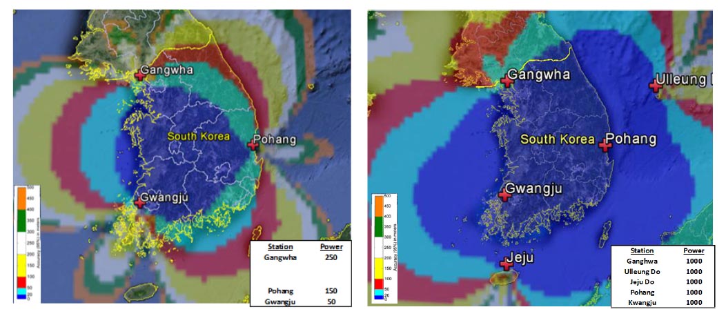
Over the next 17 months, the first phase of the installation calls for purchase of a Nautel NL series eLoran transmitter (250kW ERP) from UrsaNav for the Ganghwa station near the border with North Korea and construction of a 190-meter tall antenna there. The current Loran-C transmitters at the Pohang station (150-kilowatt) on the east coast and Gwangju station (50-kilowatt) on the southwest coast will be upgraded to eLoran capability.
Test operations are to begin in 2017, with initial operational capability beginning in 2018, followed by an evaluation of the operations in preparation for the second phase of the eLoran program.
Integrated GPS/eLoran receiver development to support the Korean eLoran program and the e-Navigation program is also under discussion. The Korean e-Navigation program recently secured budget of $121 million for five years.
In the words of the International Maritime Organization (IMO), "E-Navigation is the harmonized collection, integration, exchange, presentation and analysis of maritime information onboard and ashore by electronic means to enhance berth to berth navigation and related services, for safety and security at sea and protection of the marine environment.”


