Maritime search and rescue (SAR) operations do not fit the usual and customary operational modes for aircraft operations. Consequently, neither do their navigation and flight management system (FMS) requirements.
Maritime search and rescue (SAR) operations do not fit the usual and customary operational modes for aircraft operations. Consequently, neither do their navigation and flight management system (FMS) requirements.
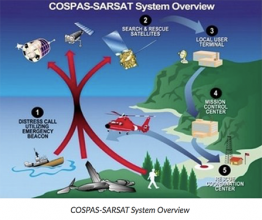
SAR missisions are not based on schedules but rather on ad hoc events and flights. Once the mission control center receives word of an accident (ship disaster, aircraft crash, etc.), an aircraft receives a mission order and begins a high-speed ferry flight to the area of concern. After arrival in the area of the incident, the aircraft typically performs a low-altitude (500 to 1,500 feet), low-speed search flight to locate survivors and the vessel.
In executing this search, the crew employs a suite of surveillance radars, electro-optical sensor, and scanning and direction finding equipment to localize transmissions of emergency beacons that may have been activated during the accident. Once the target (person, ship, aircraft) is found, the crew drops needed equipment, such as life rafts or pumps, out of the aircraft.
The target position and other details are reported to the mission control center in order to initiate further rescue activities. All of these activities require precise navigation and sensor control, which may be obtained by a number of GNSS/GPS applications on board the aircraft.
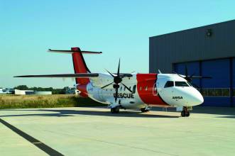
This article describes an airborne surveillance system, AeroMission, developed by Aerodata AG, and the GPS/inertial navigation system (INS) that supports its operation.
In addition to SAR missions, AeroMission is also suitable for maritime surveillance, border and anti-smuggling patrols, pollution detection and mapping, fishery control, offshore oil field monitoring, and research applications.
System Overview
AeroMission has been developed to provide high reliability, redundancy, and efficiency. It was designed using modular architecture and state of the art technology.
In supporting AeroMission, an integrated GPS/IMU navigation system — AeroNav — combines the GPS advantages of long-term stability and absolute accuracy with those of inertial navigation — short-term accuracy during phases of high dynamics in which GPS positioning may be lost or degraded.
A separate GPS/INS system also provides attitude reference by using strapdown algorithms providing position and velocity solutions. Turn rates and accelerations given by the IMU are corrected by the GPS pseudorange measurements. These corrections are calculated by a Kalman filter.
The basic system components include:
• surveillance radar (using the separate GPS-supported INS)
• forward-looking infrared (FLIR) sensor (using GPS services provided through AeroNav)
• infrared/ultraviolet (IR/UV) scanner (using a dedicated GPS-supported INS)
• Mission management and guidance system (using GPS services through AeroNav)
• SAR Homing Device
• HF, VHF, UHF, and satellite communication
• Intercom including communication relay
• Photo/video camera
• Ergonomic operator work stations
Other sensors such as side-looking airborne radar or microwave radiometer can be integrated as options into the suite.
. . .
Sensor Suite
In addition to the navigation system, moving map display, system software, and databases, AeroMission incorporates a number of additional sensors to aid its surveillance and reporting functions.
- Surveillance Radar . . .
- Electro-optical/infrared sensor . . .
- AIS and direction finding . . .
. . .
Mission Management
TheAeroMission management suite is an integrated solution that consists of equipment and software for sensor operation and control; sensor data gathering, storage, and evaluation; mission reporting, and communications control and recording.
. . .
Flight Deck Interface
The mission system has a number of interfaces to the flight deck in order to support the mission and decrease the work load of both the cabin crew and the flight deck crew.
. . .
System Qualification and Certification
The qualification and certification process for the project was quite challenging. All modifications of the airframe have been certified through a Supplemental Type Certificate (STC) approved by European Aviation Safety Agency.
. . .
Operational Experiences
During the test flights and also during the first 10 months of operations, AeroMission installed in a DO 328 aircraft has demonstrated its reliability and efficiency with an overall service availability of more than 99 percent . . .
For the complete story, including figures, graphs, and images, please download the PDF of the article, above.


